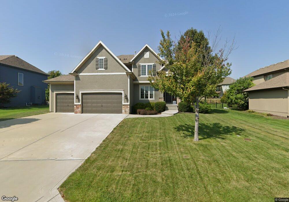
212 SW Ansel Adams Dr Lees Summit, MO 64081
Estimated Value: $655,349 - $764,000
4
Beds
4
Baths
3,140
Sq Ft
$226/Sq Ft
Est. Value
About This Home
This home is located at 212 SW Ansel Adams Dr, Lees Summit, MO 64081 and is currently estimated at $710,837, approximately $226 per square foot. 212 SW Ansel Adams Dr is a home located in Jackson County with nearby schools including Cedar Creek Elementary School, Pleasant Lea Middle School, and Lee's Summit Senior High School.
Ownership History
Date
Name
Owned For
Owner Type
Purchase Details
Closed on
Sep 8, 2023
Sold by
Dunavant Adam M
Bought by
Dunavant Family Trust
Current Estimated Value
Purchase Details
Closed on
Aug 30, 2011
Sold by
Summit Custom Homes Llc
Bought by
Niemeyer Ryan L and Niemeyr Melissa A
Home Financials for this Owner
Home Financials are based on the most recent Mortgage that was taken out on this home.
Original Mortgage
$321,950
Interest Rate
4.58%
Mortgage Type
New Conventional
Purchase Details
Closed on
Oct 28, 2010
Sold by
Gale Communities Inc
Bought by
Summit Custom Homes Llc
Home Financials for this Owner
Home Financials are based on the most recent Mortgage that was taken out on this home.
Original Mortgage
$288,325
Interest Rate
4.36%
Mortgage Type
Construction
Create a Home Valuation Report for This Property
The Home Valuation Report is an in-depth analysis detailing your home's value as well as a comparison with similar homes in the area
Home Values in the Area
Average Home Value in this Area
Purchase History
| Date | Buyer | Sale Price | Title Company |
|---|---|---|---|
| Dunavant Family Trust | -- | None Listed On Document | |
| Niemeyer Ryan L | -- | Kansas City Title Inc | |
| Summit Custom Homes Llc | -- | Chicago |
Source: Public Records
Mortgage History
| Date | Status | Borrower | Loan Amount |
|---|---|---|---|
| Previous Owner | Niemeyer Ryan L | $321,950 | |
| Previous Owner | Summit Custom Homes Llc | $288,325 |
Source: Public Records
Tax History Compared to Growth
Tax History
| Year | Tax Paid | Tax Assessment Tax Assessment Total Assessment is a certain percentage of the fair market value that is determined by local assessors to be the total taxable value of land and additions on the property. | Land | Improvement |
|---|---|---|---|---|
| 2025 | $8,048 | $104,781 | $16,777 | $88,004 |
| 2024 | $8,048 | $111,454 | $12,673 | $98,781 |
| 2023 | $7,989 | $111,454 | $15,671 | $95,783 |
| 2022 | $6,396 | $79,230 | $10,992 | $68,238 |
| 2021 | $6,528 | $79,230 | $10,992 | $68,238 |
| 2020 | $6,271 | $75,369 | $10,992 | $64,377 |
| 2019 | $6,100 | $75,369 | $10,992 | $64,377 |
| 2018 | $1,857,731 | $71,321 | $11,406 | $59,915 |
| 2017 | $6,281 | $71,321 | $11,406 | $59,915 |
| 2016 | $6,281 | $71,288 | $12,350 | $58,938 |
| 2014 | $6,148 | $68,401 | $12,341 | $56,060 |
Source: Public Records
Map
Nearby Homes
- 216 SW Ansel Adams Dr
- 2909 SW Lewis Dr
- Mariah Plan at Winterset Valley
- Ashland Plan at Winterset Valley
- Oakleigh Plan at Winterset Valley
- Forrester 2824 Plan at Winterset Valley
- Regency Plan at Winterset Valley
- Bentley Plan at Winterset Valley
- Forrester II Plan at Winterset Valley
- Oakshire Plan at Winterset Valley
- Windsong Plan at Winterset Valley
- Mariner II Plan at Winterset Valley
- Carolina Plan at Winterset Valley
- Mariner Plan at Winterset Valley
- Monticello Plan at Winterset Valley
- Monterey Plan at Winterset Valley
- Monterey 2655 Plan at Winterset Valley
- Oasis Plan at Winterset Valley
- Destiny Plan at Winterset Valley
- Cypress Plan at Winterset Valley
- 216 Ansel Adams
- 213 SW Mackenzie Dr
- 209 SW Mackenzie
- 220 SW Ansel Adams Dr
- 221 SW Roosevelt Ridge
- 225 SW Roosevelt Ridge
- 3033 SW Lewis Place
- 3016 SW Lewis Dr
- 205 SW Mackenzie
- 217 SW Roosevelt Ridge
- 3029 SW Lewis Place
- 200 SW Ansel Adams Dr
- 198 Ansel Adams
- 224 SW Ansel Adams Dr
- 201 SW Ansel Adams Dr
- 200 SW Mackenzie Dr
- 201 SW Mackenzie
- 3012 SW Lewis Dr
- 226 SW Roosevelt Ridge