
2121 Uplong St West Bloomfield, MI 48324
Estimated payment $7,179/month
Highlights
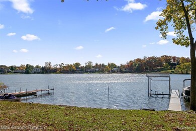
- 112 Feet of Waterfront
- Deck
- Cathedral Ceiling
- Built-In Refrigerator
- Ranch Style House
- Covered Patio or Porch
About This Home
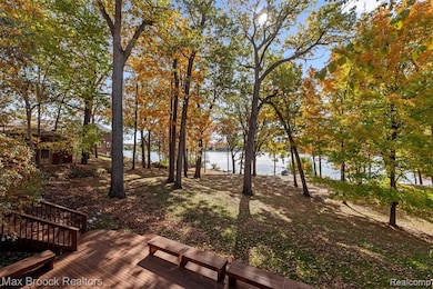
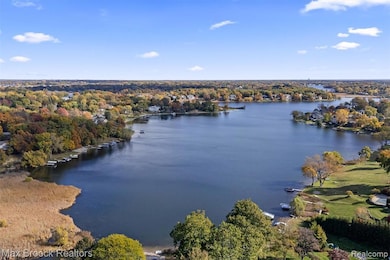
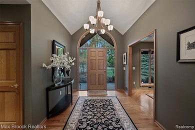
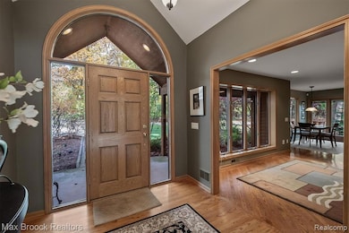
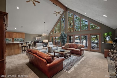
Experience the feeling of Northern Michigan lake life, while being in the heart of West Bloomfield Township. Tucked among mature trees, Uplong is a quiet, dead-end street overlooking Upper Long Lake. This stone and cedar ranch, with a walkout lower level, is the second to last home at the end of the street. Offering the best of both worlds: spectacular, elevated views and a private dock on all-sports Upper Long Lake, without having to pay lakefront property taxes. This home has a one-fourteenth ownership in Outlot A, which has over 300’ of direct lake frontage. Solid wood front door flanked by sidelight windows and an arched transom window above. The great room, with a stone fireplace, is the focal point of the home. A soaring cathedral ceiling with exposed beam and an expansive wall of windows, showcases panoramic lake views. Adjacent dining area and kitchen completely open to each other. Granite kitchen featuring raised panel Maple cabinets. Bosch double oven, Thermador four burner gas range and new GE Monogram refrigerator (2024). Countertop seating & adjacent breakfast nook. Private deck off the primary suite, plantation shutters, large walk-in closet. New spa-like primary bathroom (2022) featuring euro glass shower & soaking tub. Second bedroom with lake views, full bathroom, a library/den and laundry room completes the entry level. Entertain off the lake in the walkout lower level. Second fireplace, large family room, wet bar, full bathroom & the third bedroom, currently used as an office. Two walls of floor to ceiling windows & doorwalls opens to the multi-tiered deck. Two car garage, plus an additional two car garage off the walkout, great for boat storage or take your golf cart down to the lake! Second laundry in the walkout. Home security system. Pella windows & doorwalls. Minutes from all the dining & shopping on Telegraph. Easy access to I-75. Thoughtfully designed to capture the best of Michigan lake living! Experience the tranquility of Upper Long Lake
Listing Agent
Max Broock, REALTORS®-Birmingham License #6501359589 Listed on: 11/02/2025

Home Details
Home Type
- Single Family
Est. Annual Taxes
Year Built
- Built in 1952 | Remodeled in 2022
Lot Details
- 0.41 Acre Lot
- Lot Dimensions are 112 x 200 x 112 x 200
- 112 Feet of Waterfront
- Street terminates at a dead end
- Sprinkler System
HOA Fees
- $19 Monthly HOA Fees
Home Design
- Ranch Style House
- Block Foundation
- Asphalt Roof
- Stone Siding
Interior Spaces
- 2,123 Sq Ft Home
- Cathedral Ceiling
- Ceiling Fan
- Gas Fireplace
- Plantation Shutters
- Living Room with Fireplace
- Water Views
- Security System Owned
Kitchen
- Breakfast Area or Nook
- Double Oven
- Gas Cooktop
- Microwave
- Built-In Refrigerator
- Bosch Dishwasher
- Dishwasher
- Stainless Steel Appliances
- Trash Compactor
- Disposal
Bedrooms and Bathrooms
- 3 Bedrooms
- 3 Full Bathrooms
- Soaking Tub
Laundry
- Laundry Room
- Dryer
- Washer
Finished Basement
- Walk-Out Basement
- Sump Pump
- Fireplace in Basement
Parking
- 4 Car Direct Access Garage
- Driveway
Outdoor Features
- Shared Waterfront
- Deck
- Covered Patio or Porch
- Exterior Lighting
Location
- Ground Level
Utilities
- Forced Air Heating and Cooling System
- Heating System Uses Natural Gas
- Programmable Thermostat
- Natural Gas Water Heater
- High Speed Internet
- Cable TV Available
Listing and Financial Details
- Assessor Parcel Number 1812227019
Community Details
Overview
- Upper Long Woods Association
- Upper Long Woods Subdivision
Amenities
- Laundry Facilities
Recreation
- Water Sports
Map
Home Values in the Area
Average Home Value in this Area
Tax History
| Year | Tax Paid | Tax Assessment Tax Assessment Total Assessment is a certain percentage of the fair market value that is determined by local assessors to be the total taxable value of land and additions on the property. | Land | Improvement |
|---|---|---|---|---|
| 2024 | $11,899 | $471,370 | $0 | $0 |
| 2022 | $11,343 | $412,160 | $108,380 | $303,780 |
| 2021 | $14,486 | $375,440 | $0 | $0 |
| 2020 | $10,376 | $351,390 | $108,380 | $243,010 |
| 2018 | $13,796 | $324,520 | $108,750 | $215,770 |
| 2015 | -- | $300,990 | $0 | $0 |
| 2014 | -- | $278,480 | $0 | $0 |
| 2011 | -- | $262,480 | $0 | $0 |
Property History
| Date | Event | Price | List to Sale | Price per Sq Ft |
|---|---|---|---|---|
| 11/02/2025 11/02/25 | For Sale | $1,095,000 | -- | $516 / Sq Ft |
Purchase History
| Date | Type | Sale Price | Title Company |
|---|---|---|---|
| Deed | $840,000 | -- | |
| Deed | $385,000 | -- |
Mortgage History
| Date | Status | Loan Amount | Loan Type |
|---|---|---|---|
| Previous Owner | $500,000 | No Value Available | |
| Previous Owner | $176,000 | No Value Available |
Source: Realcomp
MLS Number: 20251050323
APN: 18-12-227-019
Disclaimer: Certain information contained herein is derived from information provided by parties other than Homes.com. All information provided is deemed reliable, but is not guaranteed to be accurate and should be independently verified.
![]() IDX provided courtesy of Realcomp II Ltd. via Ten-X and MLS
IDX provided courtesy of Realcomp II Ltd. via Ten-X and MLS
Copyright 2025 Realcomp II Ltd. Shareholders
IDX information is provided exclusively for consumers' personal, noncommercial use and may not be used for any purpose other than to identify prospective properties consumers may be interested in purchasing. The accuracy of all information, regardless of source, is not guaranteed or warranted. All information should be independently verified.
Listing Information presented by local MLS brokerage: Ten-X, local REALTOR®- Arlene Richardson - (888)-952-6393
- 2665 Middlebelt Rd
- 2300 Pine Lake Rd
- 2360 Pineview
- 2954 Long Ridge Ct
- 1831 Long Pointe Dr
- 2372 Pine Lake Rd
- 2622 Pine Ridge Rd
- 2779 Turtle Lake Dr
- 3668 Bayou Dr
- 2759 Turtle Ridge Dr
- 2230 Middlebelt Rd
- 2216 Middlebelt Rd
- 2785 Turtle Lake Dr
- 2276 Shore Hill Dr
- 2756 Turtle Bluff Dr
- 1853 W Bend Dr
- 1772 Heron Ridge Dr
- 1947 Maplewood Ave
- 1887 Harvest Ln
- 1968 Maplewood Ave
- 2534 Depew Dr
- 2510 Woodrow Wilson Blvd
- 2126 Woodrow Wilson Blvd
- 2363 Hester Ct
- 1700 Hamilton Dr
- 2433 Kleist Ct
- 1991 Lakeward Ln
- 2114 Bordeaux St
- 2380 Klingensmith Rd
- 1924 Klingensmith Rd
- 1944 Klingensmith Rd Unit 41B
- 3271 Christopher Ln
- 3273 Millwall Ave
- 3170 Orchard Lake Rd Unit 6
- 3170 Orchard Lake Rd Unit Vacant Lot
- 1610-1681 Bloomfield Place Dr
- 1684 Rustic Ln
- 1732 Sylvan Glen
- 2083 S Telegraph Rd
- 1653 Cass Lake Rd Unit D