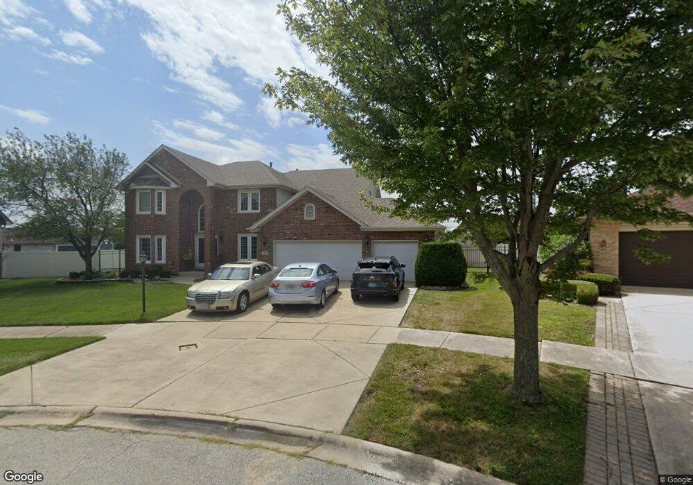
21212 Kaitlin Ct Matteson, IL 60443
West Matteson NeighborhoodEstimated Value: $415,000 - $489,000
3
Beds
3
Baths
3,142
Sq Ft
$139/Sq Ft
Est. Value
About This Home
This home is located at 21212 Kaitlin Ct, Matteson, IL 60443 and is currently estimated at $438,139, approximately $139 per square foot. 21212 Kaitlin Ct is a home located in Cook County with nearby schools including Colin Powell Middle School.
Ownership History
Date
Name
Owned For
Owner Type
Purchase Details
Closed on
Jan 2, 2025
Sold by
Roberts Laurence Andre
Bought by
Chicago Title Land Trust and Trust Number 9002347746
Current Estimated Value
Purchase Details
Closed on
Mar 12, 2003
Sold by
Wright Reginald and Roberts Laurence A
Bought by
Wright Reginal and Roberts Laurence A
Purchase Details
Closed on
Jan 20, 2000
Sold by
State Bank Of Countryside
Bought by
Wright Reginald and Roberts Laurence A
Home Financials for this Owner
Home Financials are based on the most recent Mortgage that was taken out on this home.
Original Mortgage
$232,500
Interest Rate
4.95%
Create a Home Valuation Report for This Property
The Home Valuation Report is an in-depth analysis detailing your home's value as well as a comparison with similar homes in the area
Home Values in the Area
Average Home Value in this Area
Purchase History
| Date | Buyer | Sale Price | Title Company |
|---|---|---|---|
| Chicago Title Land Trust | -- | Chicago Title | |
| Wright Reginal | -- | -- | |
| Wright Reginald | $291,000 | -- |
Source: Public Records
Mortgage History
| Date | Status | Borrower | Loan Amount |
|---|---|---|---|
| Previous Owner | Wright Reginald | $232,500 |
Source: Public Records
Tax History Compared to Growth
Tax History
| Year | Tax Paid | Tax Assessment Tax Assessment Total Assessment is a certain percentage of the fair market value that is determined by local assessors to be the total taxable value of land and additions on the property. | Land | Improvement |
|---|---|---|---|---|
| 2024 | $5,945 | $38,000 | $7,291 | $30,709 |
| 2023 | $7,922 | $38,000 | $7,291 | $30,709 |
| 2022 | $7,922 | $21,638 | $6,297 | $15,341 |
| 2021 | $8,093 | $21,636 | $6,296 | $15,340 |
| 2020 | $8,059 | $21,636 | $6,296 | $15,340 |
| 2019 | $9,462 | $26,181 | $5,633 | $20,548 |
| 2018 | $9,341 | $26,181 | $5,633 | $20,548 |
| 2017 | $8,924 | $26,181 | $5,633 | $20,548 |
| 2016 | $10,430 | $25,670 | $4,971 | $20,699 |
| 2015 | $10,759 | $25,670 | $4,971 | $20,699 |
| 2014 | $11,420 | $25,670 | $4,971 | $20,699 |
| 2013 | $10,472 | $25,394 | $4,971 | $20,423 |
Source: Public Records
Map
Nearby Homes
- 0 Ridgeland Ave
- 21218 Shannon Ave
- 6409 Old Plank Blvd
- 21143 Gray Hawk Dr Unit 2554
- 6423 Gray Hawk Dr Unit 2716
- 6508 Fawn Ct
- 6520 Bridle Path Dr
- 6529 Blue Sky Ln
- 52 Crocus Ln
- 66 Candlegate Cir
- 6608 Pasture Side Trail
- 51 Brushwood Dr
- 126 Knollwood Cir
- 62 Brushwood Dr
- 123 Knollwood Cir
- 65 Crocus Ln
- 25 Hearthside Dr
- 6700 Old Plank Blvd
- 1008 Willow Rd
- 513 Prairie Rd
- 21220 Kaitlin Ct
- 21206 Kaitlin Ct
- 6350 Old Plank Blvd
- 6344 Old Plank Blvd
- 21205 Kaitlin Ct
- 21228 Kaitlin Ct
- 21301 Gray Hawk Dr
- 21305 Gray Hawk Dr
- 21227 Gray Hawk Dr
- 21209 Kaitlin Ct
- 21234 Kaitlin Ct
- 21309 Gray Hawk Dr
- 21223 Gray Hawk Dr
- 6375 Patricia Dr
- 6375 Patricia Dr Unit 6375
- 21213 Kaitlin Ct
- 6373 Patricia Dr
- 6363 Patricia Dr
- 21217 Kaitlin Ct
- 21219 Gray Hawk Dr