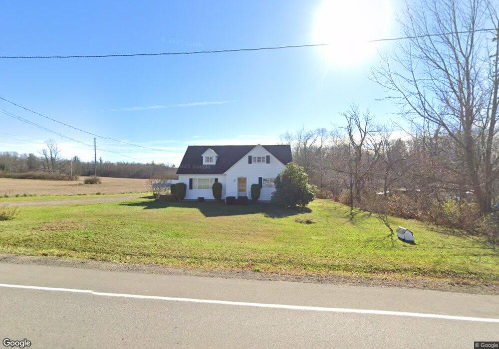
21215 Star Route Meadville, PA 16335
Estimated Value: $99,000 - $157,000
--
Bed
--
Bath
--
Sq Ft
0.5
Acres
About This Home
This home is located at 21215 Star Route, Meadville, PA 16335 and is currently estimated at $123,826. 21215 Star Route is a home located in Crawford County with nearby schools including Neason Hill Elementary School, Meadville Middle School, and Meadville Area Senior High School.
Ownership History
Date
Name
Owned For
Owner Type
Purchase Details
Closed on
Jul 17, 2024
Sold by
Sipos Margaret M and Sipos Marjorie C
Bought by
Sipos Jesse P
Current Estimated Value
Home Financials for this Owner
Home Financials are based on the most recent Mortgage that was taken out on this home.
Original Mortgage
$72,000
Outstanding Balance
$71,140
Interest Rate
6.99%
Mortgage Type
New Conventional
Estimated Equity
$52,686
Create a Home Valuation Report for This Property
The Home Valuation Report is an in-depth analysis detailing your home's value as well as a comparison with similar homes in the area
Home Values in the Area
Average Home Value in this Area
Purchase History
| Date | Buyer | Sale Price | Title Company |
|---|---|---|---|
| Sipos Jesse P | $80,000 | None Listed On Document |
Source: Public Records
Mortgage History
| Date | Status | Borrower | Loan Amount |
|---|---|---|---|
| Open | Sipos Jesse P | $72,000 |
Source: Public Records
Tax History Compared to Growth
Tax History
| Year | Tax Paid | Tax Assessment Tax Assessment Total Assessment is a certain percentage of the fair market value that is determined by local assessors to be the total taxable value of land and additions on the property. | Land | Improvement |
|---|---|---|---|---|
| 2025 | $856 | $31,575 | $2,700 | $28,875 |
| 2024 | $1,235 | $31,575 | $2,700 | $28,875 |
| 2023 | $1,266 | $31,575 | $2,700 | $28,875 |
| 2022 | $2,544 | $31,575 | $2,700 | $28,875 |
| 2021 | $2,485 | $31,575 | $2,700 | $28,875 |
| 2020 | $2,485 | $31,575 | $2,700 | $28,875 |
| 2019 | $2,485 | $31,575 | $2,700 | $28,875 |
| 2018 | $2,367 | $31,575 | $2,700 | $28,875 |
| 2017 | $2,342 | $31,575 | $2,700 | $28,875 |
| 2016 | $729 | $31,575 | $2,700 | $28,875 |
| 2015 | $729 | $31,575 | $2,700 | $28,875 |
| 2014 | -- | $31,575 | $2,700 | $28,875 |
Source: Public Records
Map
Nearby Homes
- 12336 Leslie Rd
- 20899 Star Route
- 21757 Star Route
- 12988 Raymond Dr
- 802 Brawley Ave
- 826 Irvin Ave
- 20865 Blooming Valley Rd
- 3214-024 Blooming Valley Rd
- 3210-72-6 Blooming Valley Rd
- 3210-072-6 Blooming Valley Rd
- 970 S Morgan St
- 908 Fairview Ave
- 703-705 Chestnut St
- 673 Washington St
- 685 Chestnut St
- 13329 Calvin St
- 712 State St
- 626 Walnut St
- 525 North St
- 537 Chestnut St
- 21185 Star Route
- 21208 Star Route
- 21208 Star Route 27
- 12199 Leslie Rd
- 21178 Star Route
- 12184 Leslie Rd
- 12184 Leslie Rd
- 12184 Leslie Rd
- 12208 Leslie Rd
- 21129 Star Route
- 21144 Old Ellis Hill Rd
- 21131 Star Route
- 12222 Leslie Rd
- 12245 Leslie Rd
- 12246 Leslie Rd
- 21113 Star Route
- 12265 Leslie Rd
- 21342 Star Route
- 12264 Leslie Rd
- 12286 Leslie Rd