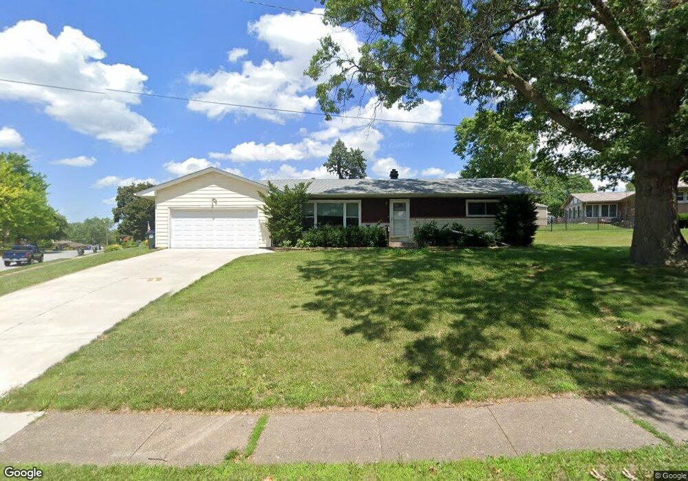
2122 W Hayes St Davenport, IA 52804
Northwest Davenport NeighborhoodEstimated Value: $197,000 - $212,000
2
Beds
2
Baths
1,248
Sq Ft
$162/Sq Ft
Est. Value
About This Home
This home is located at 2122 W Hayes St, Davenport, IA 52804 and is currently estimated at $202,541, approximately $162 per square foot. 2122 W Hayes St is a home located in Scott County with nearby schools including Adams Elementary School, Williams Intermediate School, and West High School.
Ownership History
Date
Name
Owned For
Owner Type
Purchase Details
Closed on
Apr 6, 2017
Sold by
Smith Kara and Greufe Tara
Bought by
Vargas Benjamin M
Current Estimated Value
Purchase Details
Closed on
May 23, 2008
Sold by
Machamer Wayne E
Bought by
Doyle Eileen M
Home Financials for this Owner
Home Financials are based on the most recent Mortgage that was taken out on this home.
Original Mortgage
$111,000
Interest Rate
5.93%
Mortgage Type
Purchase Money Mortgage
Create a Home Valuation Report for This Property
The Home Valuation Report is an in-depth analysis detailing your home's value as well as a comparison with similar homes in the area
Home Values in the Area
Average Home Value in this Area
Purchase History
| Date | Buyer | Sale Price | Title Company |
|---|---|---|---|
| Vargas Benjamin M | $126,500 | None Available | |
| Doyle Eileen M | $128,500 | None Available |
Source: Public Records
Mortgage History
| Date | Status | Borrower | Loan Amount |
|---|---|---|---|
| Previous Owner | Doyle Eileen M | $111,000 |
Source: Public Records
Tax History Compared to Growth
Tax History
| Year | Tax Paid | Tax Assessment Tax Assessment Total Assessment is a certain percentage of the fair market value that is determined by local assessors to be the total taxable value of land and additions on the property. | Land | Improvement |
|---|---|---|---|---|
| 2025 | $2,646 | $194,280 | $32,590 | $161,690 |
| 2024 | $3,154 | $171,980 | $32,590 | $139,390 |
| 2023 | $3,635 | $171,980 | $32,590 | $139,390 |
| 2022 | $3,475 | $157,290 | $32,590 | $124,700 |
| 2021 | $3,046 | $150,950 | $32,590 | $118,360 |
| 2020 | $3,421 | $144,450 | $32,590 | $111,860 |
| 2019 | $3,442 | $137,130 | $32,590 | $104,540 |
| 2018 | $472 | $137,130 | $32,590 | $104,540 |
| 2017 | $763 | $137,130 | $32,590 | $104,540 |
| 2016 | $2,698 | $131,900 | $0 | $0 |
| 2015 | $2,698 | $132,380 | $0 | $0 |
| 2014 | $2,746 | $132,380 | $0 | $0 |
| 2013 | $2,694 | $0 | $0 | $0 |
| 2012 | -- | $125,890 | $31,020 | $94,870 |
Source: Public Records
Map
Nearby Homes
- 2738 Kelling St
- 2820 Pacific St
- 2236 W Columbia Ave
- 2804 Oak St
- 2149 W 30th St
- 2640 Wilkes Ave
- 2222 W 30th St
- 2905 N Pine St
- 2705 N Lincoln Ave
- 3011 N Pine St
- 3205 N Pine St
- 2424 Davie St
- 1636 W Columbia Ave
- 2308 Wilkes Ave
- Lot 29 W 34th St
- 2223 W 34th St
- 2508 N Sturdevant St
- 1548 W Central Park Ave
- 2223 W Lombard St
- 1514 W Garfield St
- 2711 Volquardsen Ave
- 2106 W Hayes St
- 2721 Volquardsen None
- 2721 Volquardsen Ave
- 2125 W Hayes St
- 2117 W Hayes St
- 2105 W Hayes St
- 2131 W Hayes St
- 2138 W Hayes St
- 2724 Kelling St
- 2139 W Hayes St
- 2727 Volquardsen Ave
- 2650 Kelling St
- 2720 Volquardsen Ave
- 2732 Kelling St
- 2644 Kelling St
- 2134 W Columbia Ave
- 2142 W Columbia Ave
- 2018 W Hayes St
- 2128 W Columbia Ave