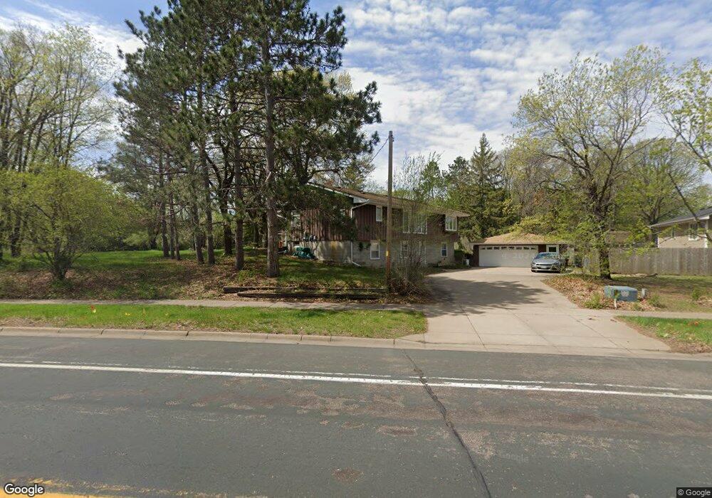
2123 131st Ave NW Coon Rapids, MN 55448
Estimated Value: $362,712 - $410,000
3
Beds
2
Baths
1,354
Sq Ft
$289/Sq Ft
Est. Value
About This Home
This home is located at 2123 131st Ave NW, Coon Rapids, MN 55448 and is currently estimated at $391,428, approximately $289 per square foot. 2123 131st Ave NW is a home located in Anoka County with nearby schools including Lucile Bruner Elementary School, Morris Bye Elementary School, and Laughlin Junior/Senior High School.
Ownership History
Date
Name
Owned For
Owner Type
Purchase Details
Closed on
Jun 15, 2015
Sold by
Ozolins Craig E and Rooker Bernadette M
Bought by
Foss Alex and Angus Foss Lisa M
Current Estimated Value
Home Financials for this Owner
Home Financials are based on the most recent Mortgage that was taken out on this home.
Original Mortgage
$191,350
Outstanding Balance
$148,628
Interest Rate
3.83%
Mortgage Type
VA
Estimated Equity
$242,800
Create a Home Valuation Report for This Property
The Home Valuation Report is an in-depth analysis detailing your home's value as well as a comparison with similar homes in the area
Home Values in the Area
Average Home Value in this Area
Purchase History
| Date | Buyer | Sale Price | Title Company |
|---|---|---|---|
| Foss Alex | $210,000 | Home Title |
Source: Public Records
Mortgage History
| Date | Status | Borrower | Loan Amount |
|---|---|---|---|
| Open | Foss Alex | $191,350 |
Source: Public Records
Tax History Compared to Growth
Tax History
| Year | Tax Paid | Tax Assessment Tax Assessment Total Assessment is a certain percentage of the fair market value that is determined by local assessors to be the total taxable value of land and additions on the property. | Land | Improvement |
|---|---|---|---|---|
| 2025 | $3,228 | $318,000 | $89,100 | $228,900 |
| 2024 | $3,228 | $312,100 | $86,100 | $226,000 |
| 2023 | $3,047 | $299,700 | $71,300 | $228,400 |
| 2022 | $2,579 | $313,500 | $71,300 | $242,200 |
| 2021 | $2,521 | $240,600 | $55,400 | $185,200 |
| 2020 | $2,452 | $230,500 | $55,400 | $175,100 |
| 2019 | $2,340 | $216,400 | $55,400 | $161,000 |
| 2018 | $2,143 | $201,900 | $0 | $0 |
| 2017 | $1,934 | $181,800 | $0 | $0 |
| 2016 | $1,974 | $163,800 | $0 | $0 |
| 2015 | -- | $163,800 | $55,000 | $108,800 |
| 2014 | -- | $135,700 | $38,900 | $96,800 |
Source: Public Records
Map
Nearby Homes
- 13416 Swallow St NW
- 1776 133rd Ave NW
- 12760 Raven St NW
- 1930 127th Cir NW
- 13519 Partridge Cir NW
- 1687 131st Ln NW
- 13182 Zion St NW
- 2147 125th Ln NW
- 2270 137th Ln NW
- 1520 129th Ave NW
- 2740 132nd Ln NW
- 12554 Grouse St NW
- 2068 124th Ln NW
- 2675 128th Ave NW
- 1593 126th Ln NW
- 12796 Bluebird St NW
- 12365 Jay St NW
- 1450 126th Ln NW
- 2201 139th Ave NW
- 1625 124th Ave NW
- 2125 131st Ave NW
- 2120 131st Ln NW
- 2126 131st Ln NW
- 2127 131st Ave NW
- 2129 131st Ave NW
- 2100 131st Ave NW
- 2134 131st Ln NW
- 13132 Osage St NW
- 2090 131st Ave NW
- 2110 131st Ave NW
- 13101 Osage St NW
- 2140 131st Ln NW
- 2125 131st Ln NW
- 13121 Osage St NW
- 2120 131st Ave NW
- 2139 131st Ave NW
- 13155 Quinn St NW
- 13131 Osage St NW
- 2099 130th Ln NW
- 2150 131st Ln NW