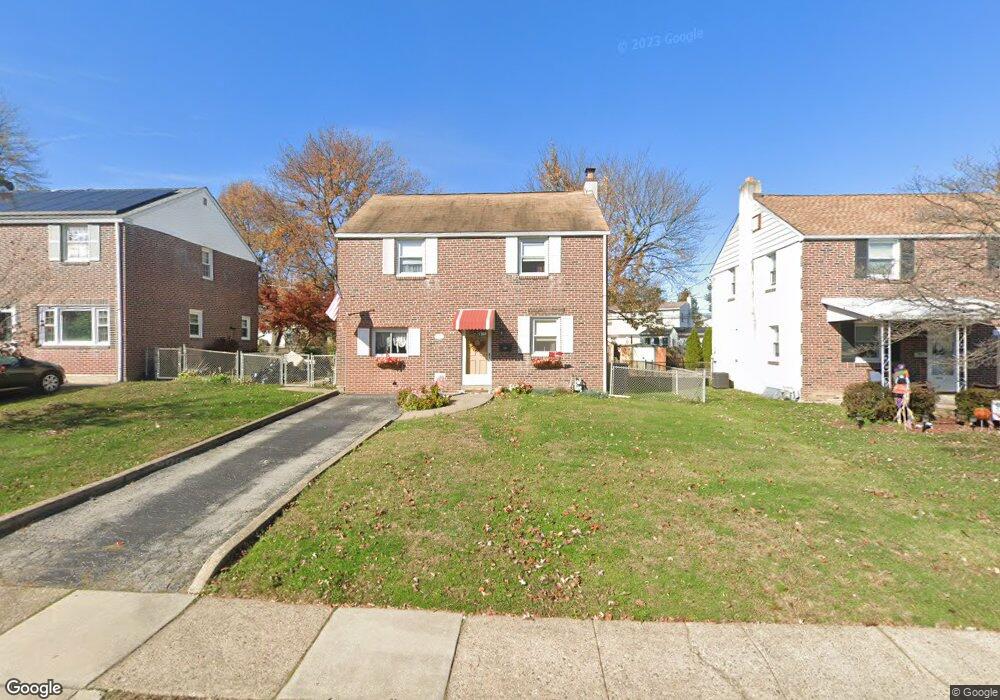
2123 Armstrong Ave Morton, PA 19070
Estimated Value: $355,825 - $394,000
4
Beds
1
Bath
1,566
Sq Ft
$242/Sq Ft
Est. Value
About This Home
This home is located at 2123 Armstrong Ave, Morton, PA 19070 and is currently estimated at $378,956, approximately $241 per square foot. 2123 Armstrong Ave is a home located in Delaware County with nearby schools including Amosland El School, Ridley Middle School, and Ridley High School.
Ownership History
Date
Name
Owned For
Owner Type
Purchase Details
Closed on
Dec 20, 2002
Sold by
Yockey Gerald E and Yockey Helena T
Bought by
Odea Michael P and Odea Helene J
Current Estimated Value
Home Financials for this Owner
Home Financials are based on the most recent Mortgage that was taken out on this home.
Original Mortgage
$120,000
Outstanding Balance
$48,309
Interest Rate
5.37%
Mortgage Type
Purchase Money Mortgage
Estimated Equity
$330,647
Create a Home Valuation Report for This Property
The Home Valuation Report is an in-depth analysis detailing your home's value as well as a comparison with similar homes in the area
Home Values in the Area
Average Home Value in this Area
Purchase History
| Date | Buyer | Sale Price | Title Company |
|---|---|---|---|
| Odea Michael P | $150,000 | -- |
Source: Public Records
Mortgage History
| Date | Status | Borrower | Loan Amount |
|---|---|---|---|
| Open | Odea Michael P | $120,000 | |
| Closed | Odea Michael P | $30,000 |
Source: Public Records
Tax History Compared to Growth
Tax History
| Year | Tax Paid | Tax Assessment Tax Assessment Total Assessment is a certain percentage of the fair market value that is determined by local assessors to be the total taxable value of land and additions on the property. | Land | Improvement |
|---|---|---|---|---|
| 2025 | $6,956 | $200,330 | $65,060 | $135,270 |
| 2024 | $6,956 | $200,330 | $65,060 | $135,270 |
| 2023 | $6,653 | $200,330 | $65,060 | $135,270 |
| 2022 | $6,440 | $200,330 | $65,060 | $135,270 |
| 2021 | $9,969 | $200,330 | $65,060 | $135,270 |
| 2020 | $5,888 | $104,220 | $33,140 | $71,080 |
| 2019 | $5,780 | $104,220 | $33,140 | $71,080 |
| 2018 | $5,708 | $104,220 | $0 | $0 |
| 2017 | $5,708 | $104,220 | $0 | $0 |
| 2016 | $584 | $104,220 | $0 | $0 |
| 2015 | $584 | $104,220 | $0 | $0 |
| 2014 | $584 | $104,220 | $0 | $0 |
Source: Public Records
Map
Nearby Homes
- 712 Pearl Ave
- 706 Brooke Ave
- 734 Brooke Cir
- 1905 Shasta Cir
- 1919 Pershing Ave
- 2238 Clayton Rd
- 810 Quince Ln
- 668 Hutchinson Terrace
- 2202 Clayton Rd
- 510 Amosland Rd
- 2329 Armstrong Ave
- 425 Hutchinson Terrace
- 1806 Unity Terrace
- 2335 Poe Rd
- 31 Faraday Ct
- 2502 Grand Ave
- 370 Amosland Rd
- 361 Amosland Rd
- 363 Holmes Rd
- 1908 Franklin Ave
- 2127 Armstrong Ave
- 2119 Armstrong Ave
- 2131 Armstrong Ave
- 2204 Elder Ave
- 2115 Armstrong Ave
- 2202 Elder Ave
- 2206 Elder Ave
- 2135 Armstrong Ave
- 628 Stanbridge Rd
- 2122 Armstrong Ave
- 2126 Armstrong Ave
- 2130 Armstrong Ave
- 2208 Elder Ave
- 2150 Elder Ave
- 2139 Armstrong Ave
- 2113 Armstrong Ave
- 2200 Elder Ave
- 2134 Armstrong Ave
- 624 Stanbridge Rd
- 2210 Elder Ave