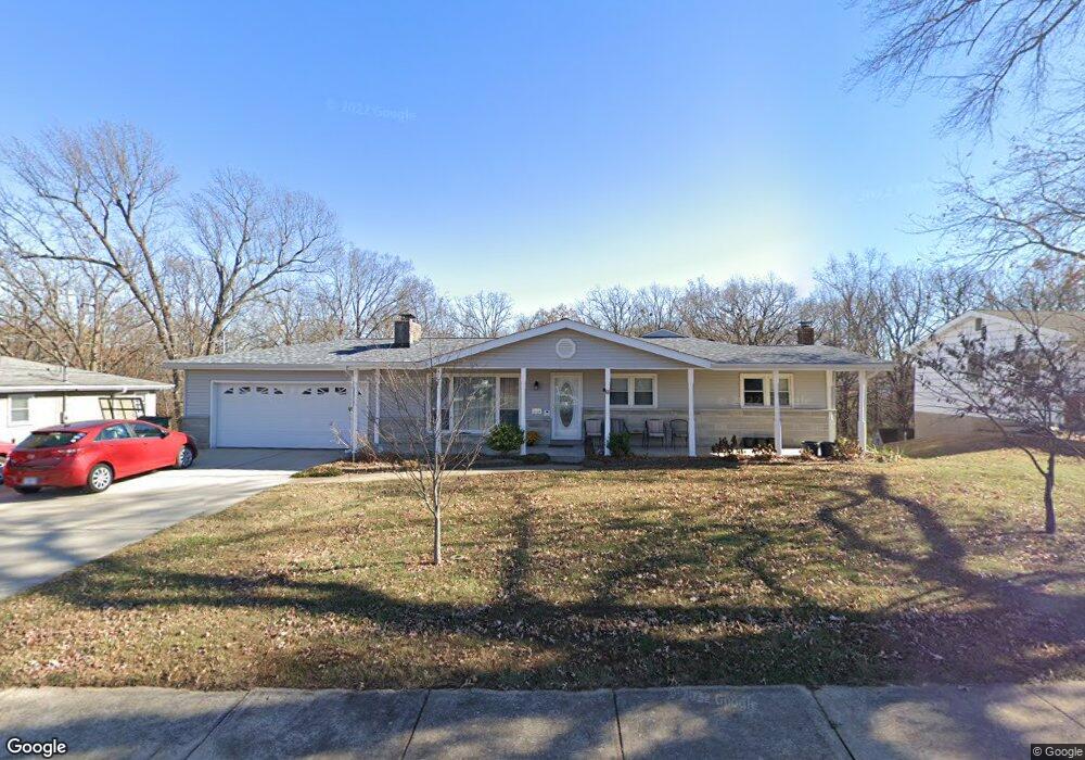
2124 Sunswept Ln High Ridge, MO 63049
Estimated Value: $252,000 - $260,000
4
Beds
2
Baths
1,451
Sq Ft
$177/Sq Ft
Est. Value
About This Home
This home is located at 2124 Sunswept Ln, High Ridge, MO 63049 and is currently estimated at $256,400, approximately $176 per square foot. 2124 Sunswept Ln is a home located in Jefferson County with nearby schools including Northwest High School, St. Anthony School, and Messenger Christian School.
Ownership History
Date
Name
Owned For
Owner Type
Purchase Details
Closed on
Jun 25, 2009
Sold by
Warrensford Eric A and Warrensford Lori G
Bought by
Westbay Peter and Westbay Carolyn
Current Estimated Value
Home Financials for this Owner
Home Financials are based on the most recent Mortgage that was taken out on this home.
Original Mortgage
$123,830
Outstanding Balance
$79,078
Interest Rate
4.97%
Mortgage Type
VA
Estimated Equity
$177,322
Purchase Details
Closed on
Dec 22, 2004
Sold by
Warren James F and Warren Karen S
Bought by
Warrensford Eric A and Warrensford Lori G
Home Financials for this Owner
Home Financials are based on the most recent Mortgage that was taken out on this home.
Original Mortgage
$136,710
Interest Rate
9%
Mortgage Type
Purchase Money Mortgage
Purchase Details
Closed on
Oct 30, 1997
Sold by
Dickson Daniel Gene and Dickson Sabra D
Bought by
Warren James F and Warren Karen S
Create a Home Valuation Report for This Property
The Home Valuation Report is an in-depth analysis detailing your home's value as well as a comparison with similar homes in the area
Home Values in the Area
Average Home Value in this Area
Purchase History
| Date | Buyer | Sale Price | Title Company |
|---|---|---|---|
| Westbay Peter | -- | Investors Title | |
| Warrensford Eric A | -- | Capital Title | |
| Warren James F | -- | Commonwealth Title |
Source: Public Records
Mortgage History
| Date | Status | Borrower | Loan Amount |
|---|---|---|---|
| Open | Westbay Peter | $123,830 | |
| Previous Owner | Warrensford Eric A | $136,710 |
Source: Public Records
Tax History Compared to Growth
Tax History
| Year | Tax Paid | Tax Assessment Tax Assessment Total Assessment is a certain percentage of the fair market value that is determined by local assessors to be the total taxable value of land and additions on the property. | Land | Improvement |
|---|---|---|---|---|
| 2025 | $1,531 | $22,900 | $1,900 | $21,000 |
| 2024 | $1,531 | $21,200 | $1,900 | $19,300 |
| 2023 | $1,531 | $21,200 | $1,900 | $19,300 |
| 2022 | $1,524 | $21,200 | $1,900 | $19,300 |
| 2021 | $1,514 | $21,200 | $1,900 | $19,300 |
| 2020 | $1,405 | $19,200 | $1,600 | $17,600 |
| 2019 | $1,403 | $19,200 | $1,600 | $17,600 |
| 2018 | $1,422 | $19,200 | $1,600 | $17,600 |
| 2017 | $1,299 | $19,200 | $1,600 | $17,600 |
| 2016 | $1,201 | $17,600 | $1,800 | $15,800 |
| 2015 | $1,234 | $17,600 | $1,800 | $15,800 |
| 2013 | -- | $16,800 | $1,800 | $15,000 |
Source: Public Records
Map
Nearby Homes
- 2141 Sunswept Ln
- 2133 Ridgedale Dr
- 2135 Linnus Dr
- 2149 Linnus Dr
- 2164 Heather Ln
- 2108 Hillsboro Valley Park Rd
- 159 Brandy Mill Cir Unit 28D
- 2112 Freckles Dr
- 2276 Appaloosa Trail
- 0 Mikel Ln
- 2060 Hillsboro Valley Park Rd
- 11 Fox Trotter Ct
- 2241 Fairway
- 2240 Fairway
- 2566 Weymouth Dr
- 0 3 Lot Blk 2 High Ridge Manor Unit MAR24044893
- 101 Lipizzan Ct
- TBD State Route 30
- 2460 Huntress Hill Ln
- 1641 S Golden Cir
- 2120 Sunswept Ln
- 2128 Sunswept Ln
- 2125 Sunswept Ln
- 2121 Sunswept Ln
- 2116 Sunswept Ln
- 2132 Sunswept Ln
- 2129 Sunswept Ln
- 2117 Sunswept Ln
- 2133 Sunswept Ln
- 2112 Sunswept Ln
- 2136 Sunswept Ln
- 2113 Sunswept Ln
- 2137 Sunswept Ln
- 2108 Sunswept Ln
- 2140 Sunswept Ln
- 5421 Dillon Rd
- 2109 Sunswept Ln
- 2133 Wildwind Ln
- 2145 Sunswept Ln
- 2104 Sunswept Ln