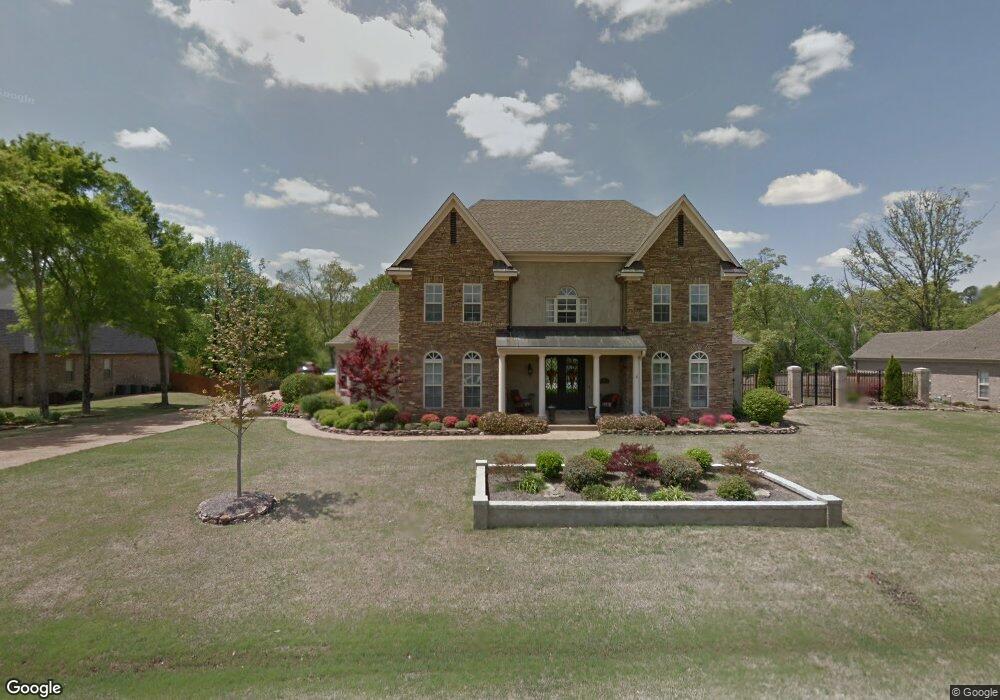
2127 Hemmingway Dr Nesbit, MS 38651
Pleasant Hill NeighborhoodEstimated Value: $504,826 - $599,000
5
Beds
4
Baths
3,593
Sq Ft
$155/Sq Ft
Est. Value
About This Home
This home is located at 2127 Hemmingway Dr, Nesbit, MS 38651 and is currently estimated at $556,207, approximately $154 per square foot. 2127 Hemmingway Dr is a home located in DeSoto County with nearby schools including DeSoto Central Primary School, DeSoto Central Elementary School, and DeSoto Central Middle School.
Ownership History
Date
Name
Owned For
Owner Type
Purchase Details
Closed on
Nov 3, 2021
Sold by
Rawlings Walter B and Rawlings Karen L
Bought by
Galloway Wiley L and Galloway Alicia R
Current Estimated Value
Home Financials for this Owner
Home Financials are based on the most recent Mortgage that was taken out on this home.
Original Mortgage
$398,000
Interest Rate
3.11%
Mortgage Type
New Conventional
Purchase Details
Closed on
Feb 15, 2010
Sold by
Community Bank Of Mississippi
Bought by
Rawlings Walter E and Rawlings Karen L
Home Financials for this Owner
Home Financials are based on the most recent Mortgage that was taken out on this home.
Original Mortgage
$252,000
Interest Rate
5.07%
Mortgage Type
New Conventional
Create a Home Valuation Report for This Property
The Home Valuation Report is an in-depth analysis detailing your home's value as well as a comparison with similar homes in the area
Home Values in the Area
Average Home Value in this Area
Purchase History
| Date | Buyer | Sale Price | Title Company |
|---|---|---|---|
| Galloway Wiley L | -- | None Available | |
| Rawlings Walter E | -- | None Available |
Source: Public Records
Mortgage History
| Date | Status | Borrower | Loan Amount |
|---|---|---|---|
| Previous Owner | Galloway Wiley L | $398,000 | |
| Previous Owner | Rawlings Walter E | $252,000 |
Source: Public Records
Tax History
| Year | Tax Paid | Tax Assessment Tax Assessment Total Assessment is a certain percentage of the fair market value that is determined by local assessors to be the total taxable value of land and additions on the property. | Land | Improvement |
|---|---|---|---|---|
| 2025 | $2,851 | $31,027 | $5,500 | $25,527 |
| 2024 | $3,406 | $31,027 | $5,500 | $25,527 |
| 2023 | $3,406 | $31,027 | $0 | $0 |
| 2022 | $3,334 | $31,027 | $5,500 | $25,527 |
| 2021 | $3,334 | $31,027 | $5,500 | $25,527 |
| 2020 | $3,334 | $31,027 | $5,500 | $25,527 |
| 2019 | $3,334 | $31,027 | $5,500 | $25,527 |
| 2017 | $3,287 | $55,656 | $30,578 | $25,078 |
| 2016 | $3,287 | $30,578 | $5,500 | $25,078 |
| 2015 | $4,355 | $55,656 | $30,578 | $25,078 |
| 2014 | $4,055 | $30,578 | $0 | $0 |
| 2013 | $4,333 | $30,328 | $0 | $0 |
Source: Public Records
Map
Nearby Homes
- 3456 Susie Cir
- 401 Getwell Rd
- 403 Getwell Rd
- 3491 Hatton Dr
- 3505 Kreunen St
- 3040 Highground Dr
- 3250 W Hartland Dr
- 3621 Hatton Dr
- 3622 Hatton Dr
- 2919 S Cherry Dr
- 3617 Kreunen St
- 3631 Kreunen St
- 2951 Eden Ln
- 2952 Eden Ln
- 2945 Molly Cove
- 2225 Highground Dr
- 2955 Molly Cove
- 2984 Eden Ln
- 2910 Malabar Place
- 2956 Molly Cove
- 2127 Hemmingway Dr
- 2103 Hemmingway Dr
- 2157 Hemmingway Dr
- 2103 Hemmingway Dr
- 2157 Hemmingway Dr
- 2116 Hemingway Dr
- 2185 Hemmingway Dr
- 2116 Hemmingway Dr
- 36 Hemmingway Dr
- 2116 Hemmingway Dr
- 2800 Manning Cir S
- 2231 Hemingway Dr
- 2757 Manning Cir S
- 2170 Hemmingway Dr
- 2170 Hemingway Ln
- 2783 Manning Cir S
- 2830 Manning Cir S
- 2811 Manning Cir S
- 2165 Chancellor Cove
- 2209 Hemmingway Dr
Your Personal Tour Guide
Ask me questions while you tour the home.