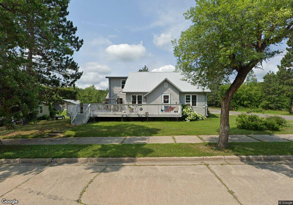
213 Birch Ave Kinney, MN 55758
Estimated Value: $186,000 - $324,872
3
Beds
2
Baths
1,563
Sq Ft
$163/Sq Ft
Est. Value
About This Home
This home is located at 213 Birch Ave, Kinney, MN 55758 and is currently estimated at $254,218, approximately $162 per square foot. 213 Birch Ave is a home located in St. Louis County with nearby schools including Merritt Elementary School and Mountain Iron-Buhl Secondary School.
Ownership History
Date
Name
Owned For
Owner Type
Purchase Details
Closed on
Nov 30, 2023
Sold by
Wiltse Sherry M and Wiltse Dale
Bought by
United States Steel Corporatio
Current Estimated Value
Purchase Details
Closed on
Aug 19, 2014
Sold by
Wiltse Sherry M and Wiltse Dale
Bought by
Wiltse Sherry M and Wiltse Dale
Home Financials for this Owner
Home Financials are based on the most recent Mortgage that was taken out on this home.
Original Mortgage
$88,000
Interest Rate
4.1%
Mortgage Type
Future Advance Clause Open End Mortgage
Purchase Details
Closed on
Jun 18, 2014
Sold by
Helmin Renee F
Bought by
Wiltse Sherry M
Create a Home Valuation Report for This Property
The Home Valuation Report is an in-depth analysis detailing your home's value as well as a comparison with similar homes in the area
Purchase History
| Date | Buyer | Sale Price | Title Company |
|---|---|---|---|
| United States Steel Corporatio | $300,000 | None Listed On Document | |
| Wiltse Sherry M | -- | All American Title Co Inc | |
| Wiltse Sherry M | $15,000 | Northeast Title Company |
Source: Public Records
Mortgage History
| Date | Status | Borrower | Loan Amount |
|---|---|---|---|
| Previous Owner | Wiltse Sherry M | $88,000 |
Source: Public Records
Tax History
| Year | Tax Paid | Tax Assessment Tax Assessment Total Assessment is a certain percentage of the fair market value that is determined by local assessors to be the total taxable value of land and additions on the property. | Land | Improvement |
|---|---|---|---|---|
| 2024 | $5,490 | $185,000 | $5,200 | $179,800 |
| 2023 | $5,490 | $174,000 | $4,900 | $169,100 |
| 2022 | $2,812 | $144,100 | $4,000 | $140,100 |
| 2021 | $2,624 | $119,600 | $3,400 | $116,200 |
| 2020 | $2,776 | $119,600 | $3,400 | $116,200 |
| 2019 | $2,328 | $112,000 | $5,100 | $106,900 |
| 2018 | $2,680 | $112,000 | $5,100 | $106,900 |
| 2017 | $1,432 | $112,000 | $5,100 | $106,900 |
| 2016 | $2,412 | $93,000 | $5,100 | $87,900 |
| 2015 | $1,125 | $18,400 | $3,500 | $14,900 |
| 2014 | $1,125 | $30,700 | $5,900 | $24,800 |
Source: Public Records
Map
Nearby Homes
- 401 Memorial Dr
- 197 Jefferson St
- 203 Jefferson St
- 205 Jefferson St
- Tbd French Rd Unit LotWP001
- TBD French Rd
- 5451 Garden Dr N
- 87XX Arbor Ln
- 6457 Colombe Rd
- 414 9th St NE
- TBD Sherwood Anderson Rd
- 8623 Labrador Ct
- 401 1st Ave NW
- 5xx 11th St NW
- 25 2nd St NW
- 17 3rd St SE
- 126 5th St NW
- 22 3rd St SW
- 126 2nd St SW
- 217 3rd Ave NW
Your Personal Tour Guide
Ask me questions while you tour the home.