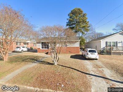
213 Clinton St Roanoke Rapids, NC 27870
Estimated Value: $50,000 - $84,000
3
Beds
1
Bath
864
Sq Ft
$71/Sq Ft
Est. Value
About This Home
This home is located at 213 Clinton St, Roanoke Rapids, NC 27870 and is currently estimated at $61,333, approximately $70 per square foot. 213 Clinton St is a home located in Halifax County with nearby schools including Roanoke Rapids High School, Gingerbread House, and Miracle Tabernacle Christian School.
Ownership History
Date
Name
Owned For
Owner Type
Purchase Details
Closed on
Jul 2, 2024
Sold by
Dunlow David M and Dunlow Debra B
Bought by
Love Keith and Neer Effie
Current Estimated Value
Home Financials for this Owner
Home Financials are based on the most recent Mortgage that was taken out on this home.
Original Mortgage
$212,000
Outstanding Balance
$211,478
Interest Rate
7.02%
Mortgage Type
Construction
Purchase Details
Closed on
Aug 14, 2003
Bought by
Dunlow David M and Dunlow Dunlow,Debra B
Create a Home Valuation Report for This Property
The Home Valuation Report is an in-depth analysis detailing your home's value as well as a comparison with similar homes in the area
Home Values in the Area
Average Home Value in this Area
Purchase History
| Date | Buyer | Sale Price | Title Company |
|---|---|---|---|
| Love Keith | $49,000 | None Listed On Document | |
| Dunlow David M | $38,000 | -- |
Source: Public Records
Mortgage History
| Date | Status | Borrower | Loan Amount |
|---|---|---|---|
| Open | Love Keith | $212,000 | |
| Previous Owner | Dunlow David Marion | $135,442 | |
| Previous Owner | Dunlow David M | $327,350 | |
| Previous Owner | Durlow David | $187,000 |
Source: Public Records
Tax History Compared to Growth
Tax History
| Year | Tax Paid | Tax Assessment Tax Assessment Total Assessment is a certain percentage of the fair market value that is determined by local assessors to be the total taxable value of land and additions on the property. | Land | Improvement |
|---|---|---|---|---|
| 2024 | $902 | $36,200 | $7,500 | $28,700 |
| 2023 | $902 | $34,500 | $7,500 | $27,000 |
| 2022 | $877 | $34,500 | $7,500 | $27,000 |
| 2021 | $834 | $34,500 | $7,500 | $27,000 |
| 2020 | $824 | $34,500 | $7,500 | $27,000 |
| 2019 | $928 | $40,400 | $6,500 | $33,900 |
| 2018 | $924 | $40,400 | $6,500 | $33,900 |
| 2017 | $896 | $40,400 | $6,500 | $33,900 |
| 2016 | $933 | $40,400 | $6,500 | $33,900 |
| 2015 | $893 | $40,400 | $6,500 | $33,900 |
| 2014 | $856 | $40,290 | $8,140 | $32,150 |
Source: Public Records
Map
Nearby Homes
- Lot 4 Clinton St
- 1315 Charlotte St
- 1703 Ivey St
- 1313 Carolina Ave
- 00 Hwy 125
- 719 E 11th St
- 1008 Carolina St
- 0 Virginia Ave
- 1211 Crew St
- 914 Franklin St
- 910 Marshall St
- Tbd Hwy 158
- 478 Hwy 158
- 1022 E 9th St
- 1401 Pruden St
- 387 Hales Branch Dr
- 903 Stoney Brook Dr
- 523 Hamilton St
- 1100 E 7th St
- 0 Chestnut St
- 213 Clinton St
- 211 Clinton St
- 215 Clinton St
- 212 Julian R Allsbrook Hwy
- 210 Julian R Allsbrook Hwy
- 216 Julian R Allsbrook Hwy
- 203 Clinton St
- 1606 Hamilton St
- 225 Clinton St
- 224 Julian R Allsbrook Hwy
- 204 Julian R Allsbrook Hwy
- 232 Clinton St
- 232 Clinton St
- 208 Clinton St
- 201 Clinton St
- 236 Clinton St
- 206 Clinton St
- 226 Julian R Allsbrook Hwy
- 244 Clinton St
- 229 Clinton St