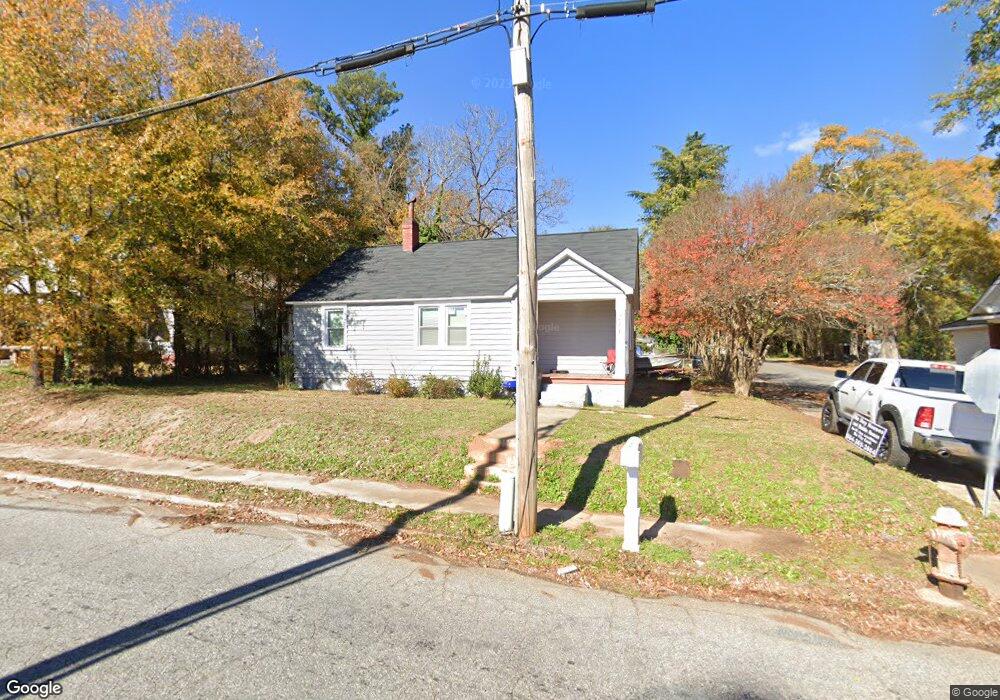
213 E Hampton St Anderson, SC 29624
Estimated Value: $63,605 - $108,000
2
Beds
1
Bath
848
Sq Ft
$107/Sq Ft
Est. Value
About This Home
This home is located at 213 E Hampton St, Anderson, SC 29624 and is currently estimated at $91,151, approximately $107 per square foot. 213 E Hampton St is a home located in Anderson County with nearby schools including Varennes Elementary School, McCants Middle School, and T.L. Hanna High School.
Ownership History
Date
Name
Owned For
Owner Type
Purchase Details
Closed on
Jun 24, 2019
Sold by
Sutton Barry Curtis
Bought by
Abreu Pable
Current Estimated Value
Purchase Details
Closed on
Mar 24, 2015
Sold by
Cya Holdings Llc
Bought by
Sutton Barry
Purchase Details
Closed on
Jul 15, 2014
Sold by
Charping Sandy and Varner Judy B
Bought by
Cya Holdings Llc
Purchase Details
Closed on
Jun 3, 2010
Sold by
Estate Of Tommy Anthony Varner and Varner Judy B
Bought by
Varner Judy B and Charping Sandy
Purchase Details
Closed on
Sep 19, 2008
Sold by
Thrasher Mary V
Bought by
Varner Tommy A
Create a Home Valuation Report for This Property
The Home Valuation Report is an in-depth analysis detailing your home's value as well as a comparison with similar homes in the area
Home Values in the Area
Average Home Value in this Area
Purchase History
| Date | Buyer | Sale Price | Title Company |
|---|---|---|---|
| Abreu Pable | $11,500 | None Available | |
| Sutton Barry | $13,000 | -- | |
| Cya Holdings Llc | $846 | -- | |
| Varner Judy B | -- | -- | |
| Varner Tommy A | -- | -- |
Source: Public Records
Tax History
| Year | Tax Paid | Tax Assessment Tax Assessment Total Assessment is a certain percentage of the fair market value that is determined by local assessors to be the total taxable value of land and additions on the property. | Land | Improvement |
|---|---|---|---|---|
| 2024 | $485 | $970 | $310 | $660 |
| 2023 | $481 | $970 | $310 | $660 |
| 2022 | $445 | $970 | $310 | $660 |
| 2021 | $416 | $790 | $230 | $560 |
| 2020 | $409 | $790 | $230 | $560 |
| 2019 | $381 | $790 | $230 | $560 |
| 2018 | $381 | $790 | $230 | $560 |
| 2017 | -- | $790 | $230 | $560 |
| 2016 | $432 | $1,500 | $150 | $1,350 |
| 2015 | $702 | $1,500 | $150 | $1,350 |
| 2014 | $691 | $1,500 | $150 | $1,350 |
Source: Public Records
Map
Nearby Homes
- 219 E Franklin St
- 306 Broyles St
- 1002 S Main St
- 908 Kennedy St
- 502 E Hampton St
- 1407 S Mcduffie St
- 1413 S Mcduffie St
- 502 Thomas St
- 501 Plain St
- 517 Thomas St
- 525 Fulwer St
- 406 Cleveland Ave
- 513 Cleveland Ave
- Lot 1 S Towers St
- 1510 S Fant St
- 1308 Roadway St
- 311 Johnson St
- 1616 Meadowbrook Cir
- 1619 Nardin Ave
- 0 Lyndon Ave
- 1020 S Manning St
- 209 E Hampton St
- 303 E Hampton St
- 1014 S Manning St
- 305 E Hampton St
- 309 E Hampton St
- 1029 S Mcduffie St
- 1025 S Mcduffie St
- 1023 S Mcduffie St
- 1012 S Manning St
- 313 E Hampton St
- 1010 S Manning St
- 315 E Hampton St
- 1009 S Manning St
- 1008 S Manning St
- 1141 S Mcduffie St
- Tract A S Mcduffie St
- 1007 S Manning St
- 319 E Hampton St
- 1202 S Mcduffie St
Your Personal Tour Guide
Ask me questions while you tour the home.