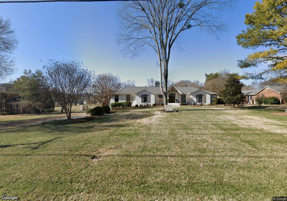
213 High Lea Rd Brentwood, TN 37027
Estimated Value: $1,668,000 - $2,246,000
--
Bed
3
Baths
4,593
Sq Ft
$439/Sq Ft
Est. Value
About This Home
This home is located at 213 High Lea Rd, Brentwood, TN 37027 and is currently estimated at $2,015,513, approximately $438 per square foot. 213 High Lea Rd is a home located in Williamson County with nearby schools including Scales Elementary School, Brentwood Middle School, and Brentwood High School.
Ownership History
Date
Name
Owned For
Owner Type
Purchase Details
Closed on
Aug 22, 2024
Sold by
Stockton Donald Jeffery and Stockton Margaret M
Bought by
Stockton Family Living Trust and Stockton
Current Estimated Value
Purchase Details
Closed on
Jun 28, 2023
Sold by
Becker David P and Becker Tracy A
Bought by
Stockton Donald Jeffery and Stockton Margaret M
Home Financials for this Owner
Home Financials are based on the most recent Mortgage that was taken out on this home.
Original Mortgage
$726,200
Interest Rate
6.39%
Mortgage Type
New Conventional
Purchase Details
Closed on
Jan 3, 2018
Sold by
Hart Joseph B and Hart Linda June
Bought by
Becker David P and Becker Tracy A
Home Financials for this Owner
Home Financials are based on the most recent Mortgage that was taken out on this home.
Original Mortgage
$450,000
Interest Rate
4.8%
Mortgage Type
New Conventional
Purchase Details
Closed on
Mar 25, 2013
Sold by
Hart Joseph Brett and Hart Linda J
Bought by
Hart Joseph B and Hart Linda June
Purchase Details
Closed on
May 12, 2011
Sold by
Hart Joseph and Cox Linda J
Bought by
Hart Joseph Brett and Hart Linda J
Home Financials for this Owner
Home Financials are based on the most recent Mortgage that was taken out on this home.
Original Mortgage
$409,325
Interest Rate
4.79%
Mortgage Type
New Conventional
Purchase Details
Closed on
May 10, 2007
Sold by
Jensen Svend A and Jensen Regina
Bought by
Hart Joseph and Cox Linda J
Home Financials for this Owner
Home Financials are based on the most recent Mortgage that was taken out on this home.
Original Mortgage
$41,000
Interest Rate
6.17%
Mortgage Type
Unknown
Purchase Details
Closed on
Jul 25, 1994
Sold by
Johnson Larry D
Bought by
Jensen Svend A
Create a Home Valuation Report for This Property
The Home Valuation Report is an in-depth analysis detailing your home's value as well as a comparison with similar homes in the area
Home Values in the Area
Average Home Value in this Area
Purchase History
| Date | Buyer | Sale Price | Title Company |
|---|---|---|---|
| Stockton Family Living Trust | -- | None Listed On Document | |
| Stockton Donald Jeffery | $2,200,000 | Lehmans Title & Escrow | |
| Becker David P | $950,000 | Foundation Title & Escrow Ll | |
| Hart Joseph B | -- | None Available | |
| Hart Joseph Brett | -- | Limestone Title & Escrow Llc | |
| Hart Joseph | $410,000 | None Available | |
| Jensen Svend A | -- | -- |
Source: Public Records
Mortgage History
| Date | Status | Borrower | Loan Amount |
|---|---|---|---|
| Previous Owner | Stockton Donald Jeffery | $726,200 | |
| Previous Owner | Stockton Donald Jeffery | $373,800 | |
| Previous Owner | Becker David P | $450,000 | |
| Previous Owner | Hart Joseph Brett | $409,325 | |
| Previous Owner | Hart Joseph | $41,000 | |
| Previous Owner | Hart Joseph | $328,000 |
Source: Public Records
Tax History Compared to Growth
Tax History
| Year | Tax Paid | Tax Assessment Tax Assessment Total Assessment is a certain percentage of the fair market value that is determined by local assessors to be the total taxable value of land and additions on the property. | Land | Improvement |
|---|---|---|---|---|
| 2025 | $5,453 | $462,475 | $150,000 | $312,475 |
| 2024 | $5,453 | $251,275 | $78,750 | $172,525 |
| 2023 | $5,453 | $251,275 | $78,750 | $172,525 |
| 2022 | $5,453 | $251,275 | $78,750 | $172,525 |
| 2021 | $5,453 | $251,275 | $78,750 | $172,525 |
| 2020 | $4,866 | $188,625 | $53,750 | $134,875 |
| 2019 | $4,866 | $188,625 | $53,750 | $134,875 |
| 2018 | $4,734 | $188,625 | $53,750 | $134,875 |
| 2017 | $4,697 | $188,625 | $53,750 | $134,875 |
| 2016 | $4,640 | $188,625 | $53,750 | $134,875 |
| 2015 | -- | $147,625 | $43,750 | $103,875 |
| 2014 | $650 | $147,625 | $43,750 | $103,875 |
Source: Public Records
Map
Nearby Homes
- 6103 Bryan Place
- 321 Granny White Pike
- 6101 Belle Rive Dr
- 1307 Old Hickory Blvd
- 528 Waxwood Dr
- 6224 Waxwood Ct
- 309 Hayeswood Dr
- 1222 Old Hickory Blvd
- 6301 Belle Rive Dr
- 520 Dekemont Ln
- 604 Foxborough Square W Unit 604
- 922 Dorset Dr
- 5218 Meadowlake Rd
- 549 Turtle Creek Dr
- 1404 Old Hickory Blvd
- 6313 Wescates Ct
- 6015 Foxborough Square E
- 6321 Wescates Ct
- 552 Grand Oaks Dr
- 5205 Williamsburg Rd
- 211 High Lea Rd
- 215 High Lea Rd
- 212 Long Valley Rd
- 217 High Lea Rd
- 209 High Lea Rd
- 214 Long Valley Rd
- 216 Long Valley Rd
- 208 Long Valley Rd
- 219 High Lea Rd
- 6101 Bryan Place
- 218 Long Valley Rd
- 301 High Lea Rd
- 6105 Bryan Place
- 215 Long Valley Rd
- 206 High Lea Rd
- 213 Long Valley Rd
- 6106 Paddock Place
- 6012 Greenleaf Ct
- 211 Long Valley Rd
- 6104 Paddock Place