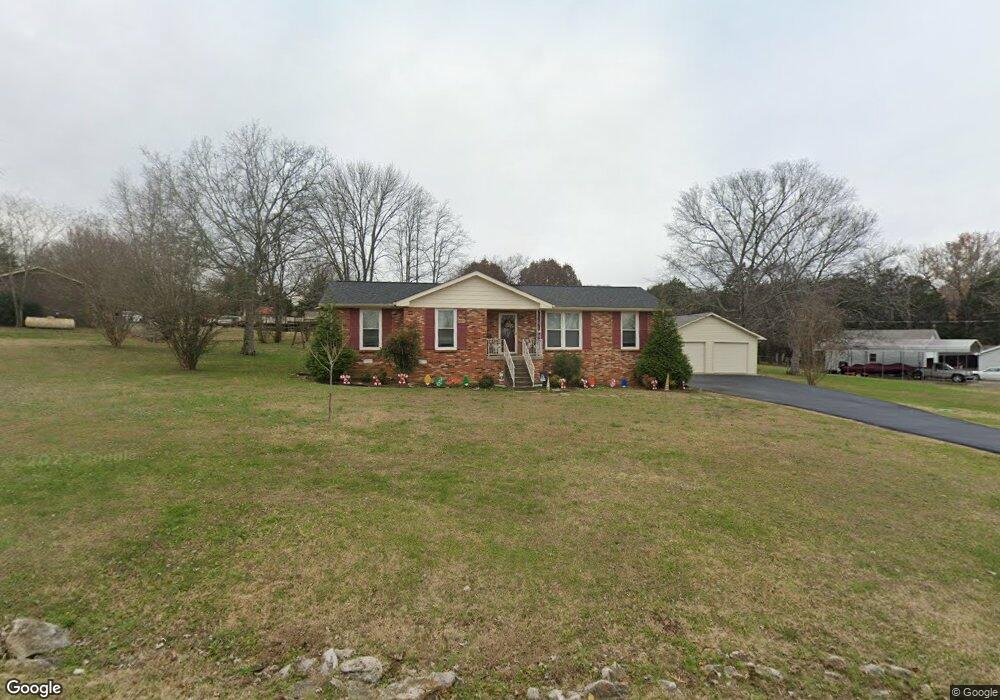
213 Jackson Trail Mount Juliet, TN 37122
Estimated Value: $307,902 - $448,000
--
Bed
2
Baths
1,230
Sq Ft
$300/Sq Ft
Est. Value
About This Home
This home is located at 213 Jackson Trail, Mount Juliet, TN 37122 and is currently estimated at $368,476, approximately $299 per square foot. 213 Jackson Trail is a home located in Wilson County with nearby schools including Mt. Juliet Elementary School, Mt. Juliet Middle School, and Green Hill High School.
Ownership History
Date
Name
Owned For
Owner Type
Purchase Details
Closed on
Apr 19, 2002
Sold by
Brookstone Developments
Bought by
Eastland Construction
Current Estimated Value
Home Financials for this Owner
Home Financials are based on the most recent Mortgage that was taken out on this home.
Original Mortgage
$210,000
Interest Rate
7.16%
Purchase Details
Closed on
Mar 30, 1990
Bought by
Parkhurst Melvin T
Purchase Details
Closed on
Aug 22, 1985
Bought by
Hand James O
Purchase Details
Closed on
Jan 2, 1984
Purchase Details
Closed on
Jan 1, 1984
Create a Home Valuation Report for This Property
The Home Valuation Report is an in-depth analysis detailing your home's value as well as a comparison with similar homes in the area
Home Values in the Area
Average Home Value in this Area
Purchase History
| Date | Buyer | Sale Price | Title Company |
|---|---|---|---|
| Eastland Construction | $30,000 | -- | |
| Parkhurst Melvin T | $69,800 | -- | |
| Hand James O | -- | -- | |
| -- | $48,000 | -- | |
| -- | $48,000 | -- |
Source: Public Records
Mortgage History
| Date | Status | Borrower | Loan Amount |
|---|---|---|---|
| Closed | Not Available | $210,000 |
Source: Public Records
Tax History Compared to Growth
Tax History
| Year | Tax Paid | Tax Assessment Tax Assessment Total Assessment is a certain percentage of the fair market value that is determined by local assessors to be the total taxable value of land and additions on the property. | Land | Improvement |
|---|---|---|---|---|
| 2024 | $1,094 | $57,325 | $18,750 | $38,575 |
| 2022 | $1,089 | $57,050 | $18,750 | $38,300 |
| 2021 | $1,152 | $57,050 | $18,750 | $38,300 |
| 2020 | $978 | $57,050 | $18,750 | $38,300 |
| 2019 | $122 | $36,400 | $12,500 | $23,900 |
| 2018 | $978 | $36,400 | $12,500 | $23,900 |
| 2017 | $978 | $36,400 | $12,500 | $23,900 |
| 2016 | $978 | $36,400 | $12,500 | $23,900 |
| 2015 | $1,008 | $36,400 | $12,500 | $23,900 |
| 2014 | $918 | $33,119 | $0 | $0 |
Source: Public Records
Map
Nearby Homes
- 212 Jackson Trail
- 415 Willis Pass
- 1120 Brookstone Blvd
- 144 W Division St
- 700 Castle Rd
- 271 Page Dr
- 1013 Brookstone Blvd
- 1520 Brookstone Cir
- 1105 Camden Cir
- 2112 Brookstone Dr
- 493 Page Dr
- 3107 Oxford Dr
- 87 E Hill St
- 1 Dogwood Dr
- 4014 Ethan Ave
- 318 Lynwood Station Blvd
- 316 Lynwood Station Blvd
- 2001 Lynnhaven Ct
- 233 Curd Rd
- 314 Lynwood Station Blvd
- 211 Jackson Trail
- 215 Jackson Trail
- 304 Jim Joe Alley
- 220 Jackson Trail
- 214 Jackson Trail
- 224 Jackson Trail
- 217 Jackson Trail
- 216 Cora Ct
- 209 Jackson Trail
- 306 Jim Joe Alley
- 303 Jim Joe Alley
- 218 Cora Ct
- 226 Jackson Trail
- 0 Jackson Trail
- 210 Jackson Trail
- 2009 Julie Dr
- 219 Jackson Trail
- 2011 Julie Dr
- 402 Willis Pass
- 404 Willis Pass