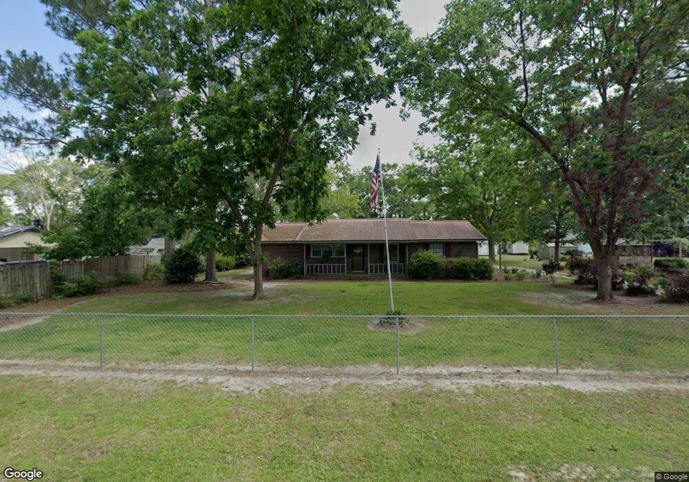
213 Mark Ln Moultrie, GA 31788
Estimated Value: $152,815 - $174,000
Studio
2
Baths
1,350
Sq Ft
$119/Sq Ft
Est. Value
About This Home
This home is located at 213 Mark Ln, Moultrie, GA 31788 and is currently estimated at $161,204, approximately $119 per square foot. 213 Mark Ln is a home located in Colquitt County with nearby schools including Odom Elementary School, Willie J. Williams Middle School, and C.A. Gray Junior High School.
Ownership History
Date
Name
Owned For
Owner Type
Purchase Details
Closed on
Dec 13, 2017
Sold by
Flagstar Bank Fsb
Bought by
Williams Martin David
Current Estimated Value
Purchase Details
Closed on
Oct 3, 2017
Sold by
Gay Jennifer
Bought by
Flagstar Bank Fsb
Purchase Details
Closed on
Dec 28, 2011
Sold by
Gay Bobby W
Bought by
Gay Jennifer Renee
Purchase Details
Closed on
Jul 29, 2005
Sold by
Horne Dorothy L
Bought by
Gay Bobby W
Home Financials for this Owner
Home Financials are based on the most recent Mortgage that was taken out on this home.
Original Mortgage
$58,000
Interest Rate
5.48%
Mortgage Type
New Conventional
Purchase Details
Closed on
May 23, 1977
Bought by
Horne Dorothy L
Create a Home Valuation Report for This Property
The Home Valuation Report is an in-depth analysis detailing your home's value as well as a comparison with similar homes in the area
Purchase History
| Date | Buyer | Sale Price | Title Company |
|---|---|---|---|
| Williams Martin David | $54,000 | -- | |
| Flagstar Bank Fsb | $56,700 | -- | |
| Gay Jennifer Renee | -- | -- | |
| Gay Bobby W | $58,000 | -- | |
| Horne Dorothy L | $16,800 | -- |
Source: Public Records
Mortgage History
| Date | Status | Borrower | Loan Amount |
|---|---|---|---|
| Previous Owner | Gay Bobby W | $58,000 |
Source: Public Records
Tax History
| Year | Tax Paid | Tax Assessment Tax Assessment Total Assessment is a certain percentage of the fair market value that is determined by local assessors to be the total taxable value of land and additions on the property. | Land | Improvement |
|---|---|---|---|---|
| 2025 | $904 | $45,450 | $800 | $44,650 |
| 2024 | $904 | $50,996 | $800 | $50,196 |
| 2023 | $1,075 | $34,941 | $800 | $34,141 |
| 2022 | $650 | $27,297 | $800 | $26,497 |
| 2021 | $558 | $22,975 | $800 | $22,175 |
| 2020 | $568 | $22,975 | $800 | $22,175 |
| 2019 | $632 | $22,975 | $800 | $22,175 |
| 2018 | $588 | $22,975 | $800 | $22,175 |
| 2017 | $592 | $21,746 | $800 | $20,946 |
| 2016 | $545 | $21,746 | $800 | $20,946 |
| 2015 | $550 | $21,746 | $800 | $20,946 |
| 2014 | $539 | $21,746 | $800 | $20,946 |
| 2013 | -- | $21,746 | $800 | $20,946 |
Source: Public Records
Map
Nearby Homes
- 473 R L Sears Rd
- 292 Robin Ln
- 0 Sardis Church Rd
- 127 Pineview Ave
- 0 Oj Johnson Rd
- 198 Lindale Ave
- 1321 Sardis Church Rd
- LOT 60 Georgia 37
- LOT 64 Georgia 37
- 1620 R L Sears Rd
- 0 Doc Darbyshire Rd
- LL261 Rowland Dr
- 1717 Park Ave SE
- 0 Mark Orton Ln
- 235 Riggins Rd
- 1225 8th Ave SE
- 209 Cherokee Dr
- 1013 6th Ave SE
- 1117 11th Ave SE
- 291 Seminole Dr
Your Personal Tour Guide
Ask me questions while you tour the home.