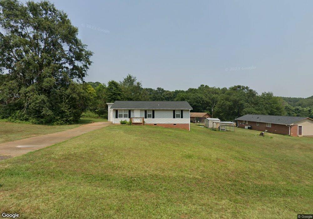
213 Range View Rd Anderson, SC 29626
Estimated Value: $155,122 - $208,000
3
Beds
--
Bath
1,142
Sq Ft
$163/Sq Ft
Est. Value
About This Home
This home is located at 213 Range View Rd, Anderson, SC 29626 and is currently estimated at $186,031, approximately $162 per square foot. 213 Range View Rd is a home located in Anderson County with nearby schools including McLees Elementary School, Robert Anderson Middle School, and Westside High School.
Ownership History
Date
Name
Owned For
Owner Type
Purchase Details
Closed on
Aug 4, 2021
Sold by
Geer Edgar
Bought by
Sfr3 020 Llc
Current Estimated Value
Purchase Details
Closed on
Aug 31, 2005
Sold by
Penneli Ernie L
Bought by
Abis Karen
Purchase Details
Closed on
Dec 10, 2003
Sold by
1St Union Natl Bank Of De
Bought by
Geer Edgar
Purchase Details
Closed on
Jan 31, 2003
Sold by
Show Me The Money Inc
Bought by
Pennell Ernie L
Purchase Details
Closed on
Jan 8, 2003
Sold by
Master In Equity
Bought by
First Union Natl Bank De
Create a Home Valuation Report for This Property
The Home Valuation Report is an in-depth analysis detailing your home's value as well as a comparison with similar homes in the area
Home Values in the Area
Average Home Value in this Area
Purchase History
| Date | Buyer | Sale Price | Title Company |
|---|---|---|---|
| Sfr3 020 Llc | $73,000 | None Available | |
| Abis Karen | $228,000 | -- | |
| Geer Edgar | $36,600 | -- | |
| Pennell Ernie L | $150,000 | -- | |
| First Union Natl Bank De | $15,000 | -- |
Source: Public Records
Tax History
| Year | Tax Paid | Tax Assessment Tax Assessment Total Assessment is a certain percentage of the fair market value that is determined by local assessors to be the total taxable value of land and additions on the property. | Land | Improvement |
|---|---|---|---|---|
| 2024 | $2,028 | $6,010 | $900 | $5,110 |
| 2023 | $2,031 | $6,010 | $900 | $5,110 |
| 2022 | $1,952 | $6,010 | $900 | $5,110 |
| 2021 | $1,402 | $4,250 | $600 | $3,650 |
| 2020 | $1,379 | $4,250 | $600 | $3,650 |
| 2019 | $1,379 | $4,250 | $600 | $3,650 |
| 2018 | $1,361 | $4,250 | $600 | $3,650 |
| 2017 | -- | $4,250 | $600 | $3,650 |
| 2016 | $1,168 | $4,060 | $390 | $3,670 |
| 2015 | $1,177 | $4,060 | $390 | $3,670 |
| 2014 | $1,156 | $4,060 | $390 | $3,670 |
Source: Public Records
Map
Nearby Homes
- 3824 Dobbins Bridge Rd
- 110 Stone Creek Dr
- 135 Westwood Cir
- 118 Strawberry Rd
- 0 Marshall Rd
- LTS C+1 Scarborough Rd
- 0 Cloverdale Dr
- Lot 1 Cloverdale Dr
- 109 Cloverdale Dr
- 232 Strawberry Rd
- 1010 Bern Cir
- 114 Meadowood Dr
- 231 Greenmeadow Cir
- 410, 426,& 436 Cleveland Rd
- 107 Canary
- 433 Shore Line Dr
- 424 Shore Line Dr
- 401 New Hope Rd
- 2114 Karen Ln
- 304 Cleveland Rd
- 213 Rangeview
- 211 Range View Rd
- 218 E Pinedale Rd
- 216 E Pinedale Rd
- 214 E Pinedale Rd
- 210 Range View Rd
- 212 E Pinedale Rd
- 206 Range View Rd
- 212 Range View Rd
- 210 E Pinedale Rd
- 207 Range View Rd
- 225 E Pinedale Rd
- 227 E Pinedale Rd
- 229 E Pinedale Rd
- 208 E Pinedale Rd
- 102 Range View Cir
- 302 E Pinedale Rd
- 109 Range View Cir
- 204 Range View Rd
- 205 Range View Rd
Your Personal Tour Guide
Ask me questions while you tour the home.