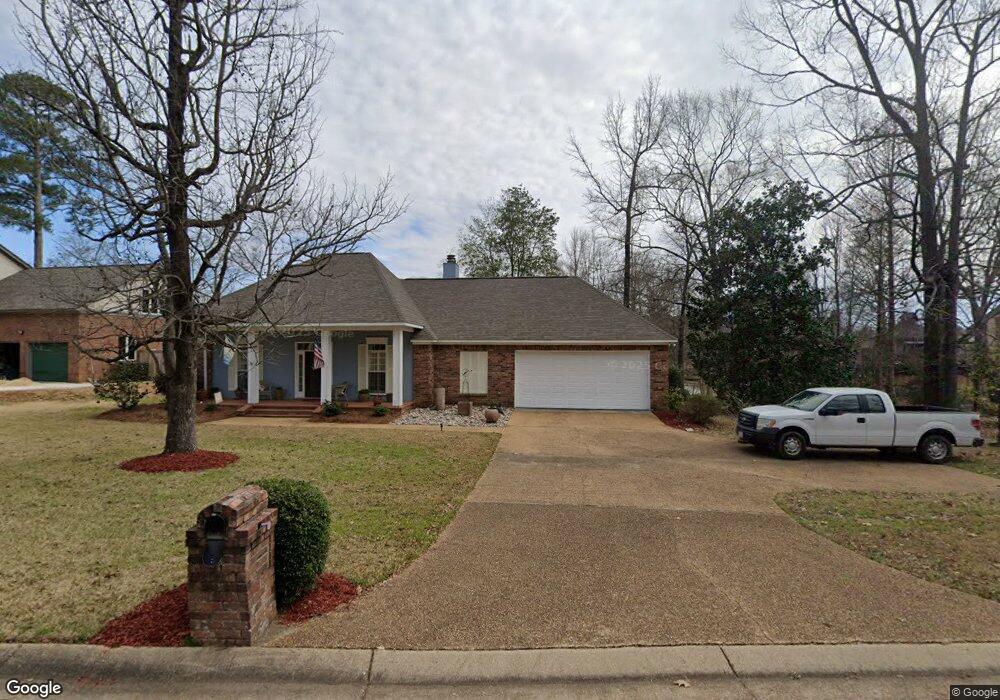
213 Ridge Cir Brandon, MS 39047
Estimated Value: $389,386 - $432,000
--
Bed
--
Bath
2,673
Sq Ft
$154/Sq Ft
Est. Value
About This Home
This home is located at 213 Ridge Cir, Brandon, MS 39047 and is currently estimated at $412,847, approximately $154 per square foot. 213 Ridge Cir is a home located in Rankin County with nearby schools including Northshore Elementary School, Northwest Rankin Middle School, and Northwest Rankin High School.
Ownership History
Date
Name
Owned For
Owner Type
Purchase Details
Closed on
Nov 24, 2021
Sold by
Evans Pamela C
Bought by
P & A Rental Properties Llc
Current Estimated Value
Purchase Details
Closed on
Sep 25, 2021
Sold by
Evans Pamela C
Bought by
P & A Rental Properties Llc
Purchase Details
Closed on
Apr 13, 2021
Sold by
Evans Pamela C
Bought by
Evans Adrian I and Evans Kennifer M
Create a Home Valuation Report for This Property
The Home Valuation Report is an in-depth analysis detailing your home's value as well as a comparison with similar homes in the area
Home Values in the Area
Average Home Value in this Area
Purchase History
| Date | Buyer | Sale Price | Title Company |
|---|---|---|---|
| P & A Rental Properties Llc | -- | -- | |
| P & A Rental Properties Llc | -- | -- | |
| P & A Rental Properties Llc | -- | Arnold Jeff | |
| P & A Rental Properties Llc | -- | Arnold Jeff | |
| Evans Adrian I | -- | None Listed On Document |
Source: Public Records
Tax History Compared to Growth
Tax History
| Year | Tax Paid | Tax Assessment Tax Assessment Total Assessment is a certain percentage of the fair market value that is determined by local assessors to be the total taxable value of land and additions on the property. | Land | Improvement |
|---|---|---|---|---|
| 2024 | $3,017 | $30,803 | $0 | $0 |
| 2023 | $2,023 | $29,065 | $0 | $0 |
| 2022 | $1,994 | $29,065 | $0 | $0 |
| 2021 | $1,994 | $29,065 | $0 | $0 |
| 2020 | $1,994 | $29,065 | $0 | $0 |
| 2019 | $2,043 | $26,252 | $0 | $0 |
| 2018 | $2,006 | $26,252 | $0 | $0 |
| 2017 | $2,006 | $26,252 | $0 | $0 |
| 2016 | $1,847 | $25,616 | $0 | $0 |
| 2015 | $1,847 | $25,616 | $0 | $0 |
| 2014 | $1,809 | $25,616 | $0 | $0 |
| 2013 | -- | $25,616 | $0 | $0 |
Source: Public Records
Map
Nearby Homes
- 808 Hunter Bay
- 1220 Foxpoint
- 506 Ridge Cir
- 420 Fox Bay Dr
- 1109 Foxpoint
- 124 Fox Hollow Bend
- 106 Bay Pointe Place
- 2150 W Fairway Dr
- 3099 E Fairway Dr
- 440 Freedom Ring Dr
- 118 Pine Ridge Cir
- 1931 Freedom Ring Dr
- 1821 Freedom Ring Dr
- 1911 Freedom Ring Dr
- 1841 Freedom Ring Dr
- 3 Highway 25 Hwy
- 622 Macbeth St
- 131 Caledonian Blvd
- 2 Highway 25 Hwy
- 0 Marshall Rd Unit 4122368