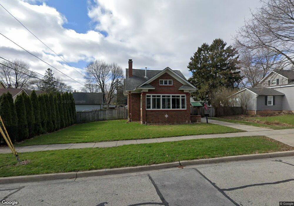
213 South St West Dundee, IL 60118
Estimated Value: $283,958 - $352,000
2
Beds
--
Bath
1,189
Sq Ft
$265/Sq Ft
Est. Value
About This Home
This home is located at 213 South St, West Dundee, IL 60118 and is currently estimated at $314,990, approximately $264 per square foot. 213 South St is a home located in Kane County with nearby schools including Dundee Highlands Elementary School, Dundee Middle School, and Dundee-Crown High School.
Ownership History
Date
Name
Owned For
Owner Type
Purchase Details
Closed on
Mar 17, 2020
Sold by
Adolf Randall
Bought by
Adolf Randall
Current Estimated Value
Purchase Details
Closed on
Aug 28, 2007
Sold by
Adolf Randall
Bought by
Adolf Randall and Trust #07E32
Purchase Details
Closed on
Nov 8, 1994
Sold by
Adolf Carolyn
Bought by
Aldof Randall
Create a Home Valuation Report for This Property
The Home Valuation Report is an in-depth analysis detailing your home's value as well as a comparison with similar homes in the area
Home Values in the Area
Average Home Value in this Area
Purchase History
| Date | Buyer | Sale Price | Title Company |
|---|---|---|---|
| Adolf Randall | -- | Attorney | |
| Adolf Randall | -- | None Available | |
| Aldof Randall | -- | -- | |
| Aldof Randall | -- | -- |
Source: Public Records
Tax History Compared to Growth
Tax History
| Year | Tax Paid | Tax Assessment Tax Assessment Total Assessment is a certain percentage of the fair market value that is determined by local assessors to be the total taxable value of land and additions on the property. | Land | Improvement |
|---|---|---|---|---|
| 2024 | $3,371 | $106,568 | $19,631 | $86,937 |
| 2023 | $3,539 | $95,886 | $17,663 | $78,223 |
| 2022 | $4,084 | $86,814 | $17,663 | $69,151 |
| 2021 | $4,188 | $81,969 | $16,677 | $65,292 |
| 2020 | $4,212 | $80,126 | $16,302 | $63,824 |
| 2019 | $4,309 | $76,065 | $15,476 | $60,589 |
| 2018 | $4,421 | $75,422 | $15,170 | $60,252 |
| 2017 | $4,522 | $70,554 | $14,191 | $56,363 |
| 2016 | $4,772 | $63,313 | $13,740 | $49,573 |
| 2015 | -- | $58,981 | $17,766 | $41,215 |
| 2014 | -- | $57,352 | $17,275 | $40,077 |
| 2013 | -- | $59,108 | $17,804 | $41,304 |
Source: Public Records
Map
Nearby Homes
- 112 Liberty St
- 505 S 3rd St
- 93 Liberty St
- 516 S 1st St
- 512 Lisa Rd
- Lot 1 View St
- 560 S 5th St
- 0000 Strom Dr
- 7 King William St
- 436 Barrington Ave
- 4 Summit St
- 849 Hemlock Dr
- 432 Illinois St
- 519 Oak Dr
- 510 N Van Buren St
- 1042 Chateau Bluff Ln
- 152 King Ave
- 709 Timothy Ct Unit 171
- 1 S Lincoln Ave
- 152 Aberdeen Dr