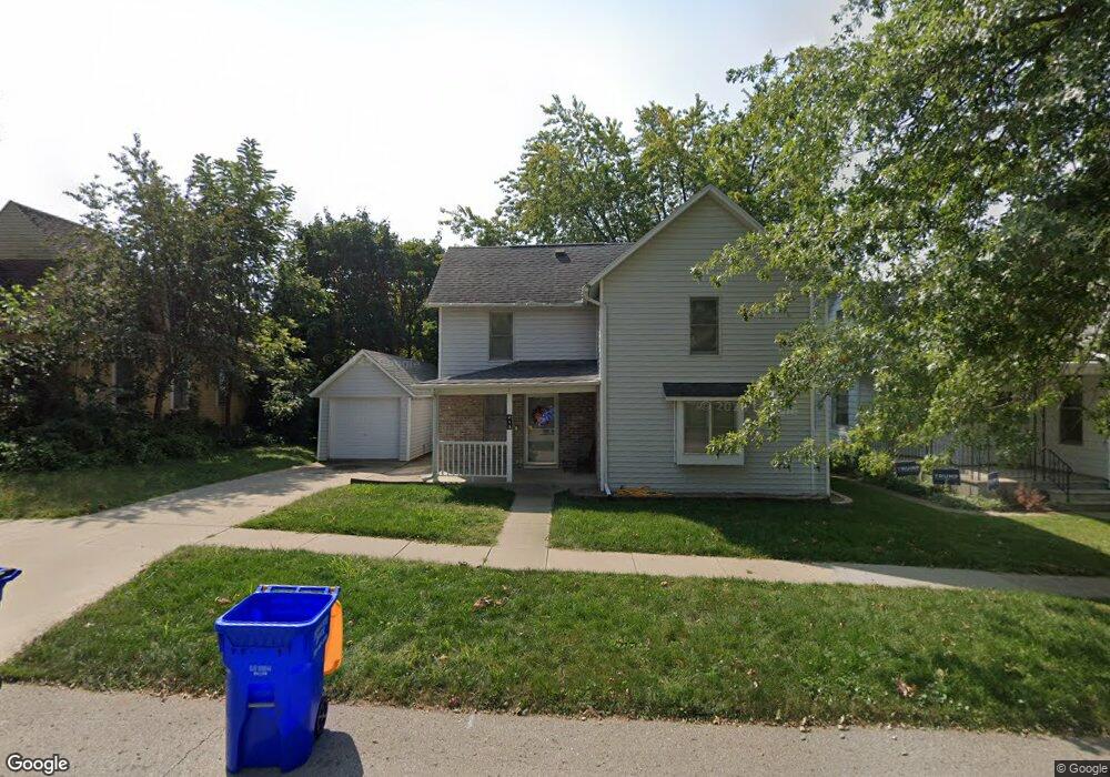
213 W Elm St Lone Tree, IA 52755
Estimated Value: $187,000 - $232,000
3
Beds
2
Baths
1,458
Sq Ft
$140/Sq Ft
Est. Value
About This Home
This home is located at 213 W Elm St, Lone Tree, IA 52755 and is currently estimated at $204,171, approximately $140 per square foot. 213 W Elm St is a home located in Johnson County with nearby schools including Lone Tree Elementary School and Lone Tree Junior/Senior High School.
Ownership History
Date
Name
Owned For
Owner Type
Purchase Details
Closed on
May 1, 2018
Sold by
Lake Bobbie L
Bought by
Hayes Alex C and Maske Abigail R
Current Estimated Value
Home Financials for this Owner
Home Financials are based on the most recent Mortgage that was taken out on this home.
Original Mortgage
$136,363
Outstanding Balance
$117,270
Interest Rate
4.44%
Mortgage Type
New Conventional
Estimated Equity
$86,901
Purchase Details
Closed on
Nov 25, 2009
Sold by
Prottsman Jaden M and Prottsman Michele R
Bought by
Lake Bobbie Joe
Home Financials for this Owner
Home Financials are based on the most recent Mortgage that was taken out on this home.
Original Mortgage
$19,350
Interest Rate
4.52%
Mortgage Type
Credit Line Revolving
Create a Home Valuation Report for This Property
The Home Valuation Report is an in-depth analysis detailing your home's value as well as a comparison with similar homes in the area
Home Values in the Area
Average Home Value in this Area
Purchase History
| Date | Buyer | Sale Price | Title Company |
|---|---|---|---|
| Hayes Alex C | $135,000 | None Available | |
| Lake Bobbie Joe | $129,000 | None Available |
Source: Public Records
Mortgage History
| Date | Status | Borrower | Loan Amount |
|---|---|---|---|
| Open | Hayes Alex C | $136,363 | |
| Previous Owner | Lake Bobbie Joe | $19,350 | |
| Previous Owner | Lake Bobbie Joe | $103,200 |
Source: Public Records
Tax History Compared to Growth
Tax History
| Year | Tax Paid | Tax Assessment Tax Assessment Total Assessment is a certain percentage of the fair market value that is determined by local assessors to be the total taxable value of land and additions on the property. | Land | Improvement |
|---|---|---|---|---|
| 2025 | $2,336 | $187,300 | $23,300 | $164,000 |
| 2024 | $2,268 | $179,300 | $23,300 | $156,000 |
| 2023 | $2,016 | $179,300 | $23,300 | $156,000 |
| 2022 | $1,992 | $136,800 | $18,400 | $118,400 |
| 2021 | $2,090 | $136,800 | $18,400 | $118,400 |
| 2020 | $2,090 | $136,800 | $18,400 | $118,400 |
| 2019 | $1,868 | $136,800 | $18,400 | $118,400 |
| 2018 | $1,974 | $121,000 | $18,400 | $102,600 |
| 2017 | $2,090 | $121,000 | $18,400 | $102,600 |
| 2016 | $2,002 | $120,200 | $18,400 | $101,800 |
| 2015 | $2,002 | $120,200 | $18,400 | $101,800 |
| 2014 | $2,140 | $105,800 | $18,400 | $87,400 |
Source: Public Records
Map
Nearby Homes
- 221 W Commercial St
- 201 N Devoe St
- 500 S Center St
- 407 E Elm St
- 106 Dorothy Ln
- 745 N Perkins St
- 5888 Sand Rd SE
- 25840 Golden Oak Ln Lot 1
- 25838 Golden Oak Ln Lot 7
- 25836 Golden Oak Ln Lot 8
- 25832 Golden Oak Ln Lot 12
- 25736 Golden Pond Ln Se Lot 17
- 25738 Golden Pond Ln Se Lot 16
- 25824 Golden Oak Ln Lot 9
- 1092 Walnut Ave Unit 209
- 1092 Walnut Ave Unit 114 Bld D
- Lot 2 116th Cir
- Lot 39 Walter Mapp Dr
- 2 Commercial Dr
- 1436 Vine Ave