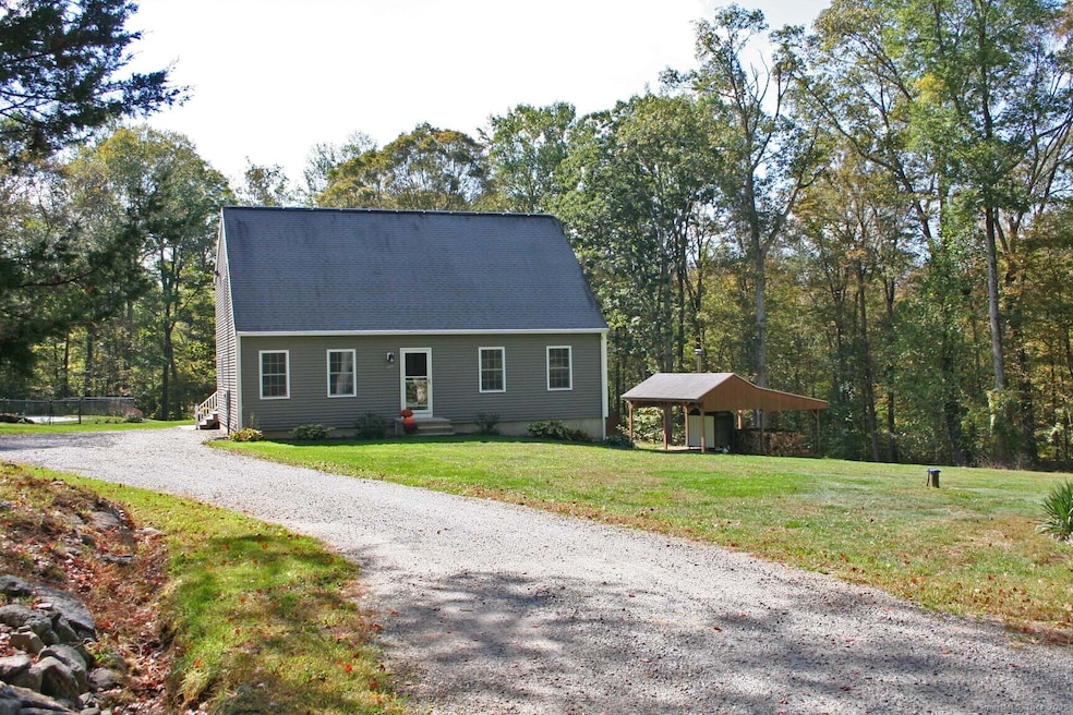
213 Waterhole Rd East Hampton, CT 06424
Estimated payment $3,434/month
Highlights
- Barn
- 5.41 Acre Lot
- Deck
- In Ground Pool
- Cape Cod Architecture
- Secluded Lot
About This Home
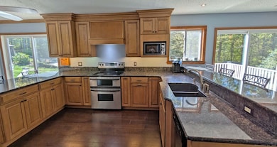
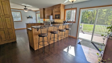
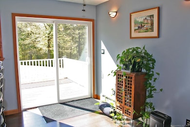
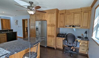
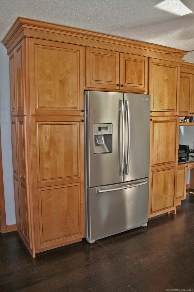
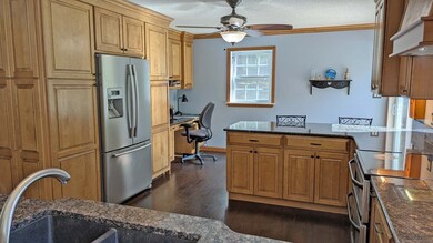
*** OPEN Saturday October 11th, 10am to Noon *** If you're looking for privacy and space in a peaceful country setting, this charming Cape Cod home is the perfect fit. Set on 5.41 scenic acres, it blends classic comfort with modern updates and energy-efficient living. The remodeled eat-in kitchen is the heart of the home, featuring granite counters, stainless-steel appliances, two breakfast bars, a casual dining area, and a handy mini-office. Two sliders open to a spacious Trex deck (new in 2021), perfect for relaxing or entertaining. The inviting living room includes chair rail detailing, and a flexible first-floor room - currently a bedroom - can also serve as a dining room, office, or den. Upstairs, the primary suite offers paddle fans and double walk-in closets, while oversized full baths on both levels add comfort and convenience. The walk-out basement includes a cozy family area with pellet stove, workshop space, and a creative built-in doggie condo, plus double doors to the back yard. Designed for efficiency, the home features owned solar panels and an outdoor wood-fired boiler providing heat and hot water to the entire house. Enjoy an in-ground pool with new liner, a 26x24 barn, 20x20 basketball court, and open yard perfect for small animals. With new siding and new windows in 2022, 2x6 construction and excellent insulation, this home offers lasting comfort, self-sufficiency, and peaceful country living. Don't miss out seeing this fantastic home!
Listing Agent
Century 21 AllPoints Realty Brokerage Phone: (860) 930-3469 License #REB.0755624 Listed on: 10/08/2025

Co-Listing Agent
Century 21 AllPoints Realty Brokerage Phone: (860) 930-3469 License #RES.0662483
Home Details
Home Type
- Single Family
Est. Annual Taxes
- $8,498
Year Built
- Built in 1991
Lot Details
- 5.41 Acre Lot
- Secluded Lot
- Property is zoned R-4
Parking
- Parking Deck
Home Design
- Cape Cod Architecture
- Concrete Foundation
- Frame Construction
- Asphalt Shingled Roof
- Vinyl Siding
Interior Spaces
- 1,960 Sq Ft Home
- Whole House Fan
- Ceiling Fan
- Attic or Crawl Hatchway Insulated
- Laundry on main level
Kitchen
- Electric Range
- Microwave
- Dishwasher
Bedrooms and Bathrooms
- 3 Bedrooms
- 2 Full Bathrooms
Basement
- Walk-Out Basement
- Basement Fills Entire Space Under The House
Pool
- In Ground Pool
- Fence Around Pool
Schools
- Memorial Elementary School
- East Hampton High School
Utilities
- Hot Water Heating System
- Heating System Uses Oil
- Private Company Owned Well
- Hot Water Circulator
- Fuel Tank Located in Basement
Additional Features
- Heating system powered by active solar
- Deck
- Barn
Listing and Financial Details
- Assessor Parcel Number 982223
Map
Home Values in the Area
Average Home Value in this Area
Tax History
| Year | Tax Paid | Tax Assessment Tax Assessment Total Assessment is a certain percentage of the fair market value that is determined by local assessors to be the total taxable value of land and additions on the property. | Land | Improvement |
|---|---|---|---|---|
| 2025 | $8,498 | $213,990 | $81,910 | $132,080 |
| 2024 | $8,140 | $213,990 | $81,920 | $132,070 |
| 2023 | $7,716 | $213,990 | $81,920 | $132,070 |
| 2022 | $7,417 | $213,990 | $81,920 | $132,070 |
| 2021 | $7,389 | $213,990 | $81,920 | $132,070 |
| 2020 | $7,227 | $218,080 | $83,300 | $134,780 |
| 2019 | $7,689 | $232,020 | $85,370 | $146,650 |
| 2018 | $7,267 | $232,020 | $85,370 | $146,650 |
| 2017 | $7,267 | $232,020 | $85,370 | $146,650 |
| 2016 | $6,831 | $232,020 | $85,370 | $146,650 |
| 2015 | $6,591 | $237,250 | $86,870 | $150,380 |
| 2014 | $5,734 | $237,250 | $86,870 | $150,380 |
Property History
| Date | Event | Price | List to Sale | Price per Sq Ft |
|---|---|---|---|---|
| 11/29/2025 11/29/25 | Pending | -- | -- | -- |
| 10/10/2025 10/10/25 | For Sale | $519,800 | -- | $265 / Sq Ft |
Purchase History
| Date | Type | Sale Price | Title Company |
|---|---|---|---|
| Quit Claim Deed | -- | -- | |
| Quit Claim Deed | -- | -- | |
| Warranty Deed | $142,727 | -- |
Mortgage History
| Date | Status | Loan Amount | Loan Type |
|---|---|---|---|
| Previous Owner | $248,800 | No Value Available | |
| Previous Owner | $160,000 | No Value Available | |
| Previous Owner | $33,000 | No Value Available |
Source: SmartMLS
MLS Number: 24132150
APN: EHAM-000036-000096-000001-000004
Disclaimer: Certain information contained herein is derived from information provided by parties other than Homes.com. All information provided is deemed reliable, but is not guaranteed to be accurate and should be independently verified.
![]() IDX information is provided exclusively for personal, non-commercial use, and may not be used for any purpose other than to identify prospective properties consumers may be interested in purchasing. Information is deemed reliable but not guaranteed.
IDX information is provided exclusively for personal, non-commercial use, and may not be used for any purpose other than to identify prospective properties consumers may be interested in purchasing. Information is deemed reliable but not guaranteed.
- 115 Sillimanville Rd
- 115 Lakeview Dr
- 145 Lakeview Dr
- 154 Falls Rd
- 67 Pickerel Lake Rd
- 53 Falls Bashan Rd
- 53 Falls Rd
- 597 Westchester Rd
- 42 Dogwood Rd
- 92 Cherry Swamp Rd
- 71 Cherry Swamp Rd
- 8 Augusta Cir Unit 8
- 8 Tom Rd
- 398 E Haddam Moodus Rd
- 5 Joe Williams Rd
- 10 Cherry Swamp Rd
- 67 Moodus Leesville Rd
- 21 Olmstead Rd
- 23 Olmstead Rd
- 119 Colchester Ave