$44,000
SOLD JUL 18, 2025

213 Wynn Ferry Rd Big Sandy, TN 38221

19 Acres
$2,322 Price per Acre
825,462 Sq Ft Lot

Recently Sold

58% Below List Price

440 Days on Market

About This Lot

As of July 2025

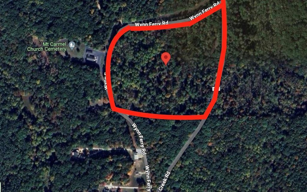
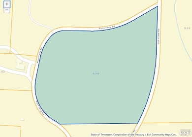
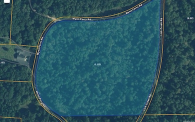
LAND THAT PERCS FOR A 4BR HOUSE WITH NEARLY 360 DEGREES OF ROAD FRONTAGE. This wooded acreage would be a great place to build your dream home, have a farm, use as hunting property, or possibly a campground or RV park being within 5 miles of Lick Creek boat Landing. The possibilities are UNLIMITED as this land is unrestricted and ready for you to use it as you want!

Last Agent to Sell the Property

Jennifer French

Bass Realty Company Brokerage Phone: 7316429612 License #350812 Listed on: 04/17/2024

Last Buyer's Agent

Benjamin Reed

Keith Arnold Realty & Auction License #358888

Property Details

Property Type

  • Land

Est. Annual Taxes

  • $170

Lot Details

  • 18.95 Acre Lot
  • Lot Dimensions are 985 x 955
  • Natural State Vegetation

Schools

  • Big Sandy Elementary And Middle School
  • Big Sandy High School

Utilities

  • Natural Gas Not Available

Listing and Financial Details

  • Assessor Parcel Number 006.00 special interest 000

Property Details

Property Type

Land

Est. Annual Taxes

$170

Lot Details

0

Listing Details

  • Property Sub Type: Unimproved Land
  • Prop. Type: Land
  • Subdivision Name: None
  • Attribution Contact: 7316429612
  • Special Features: None

Interior Features

  • Possible Use: Residential, Timber

Exterior Features

  • Acres: 18.95
  • Waterfront Features: W/I 5 miles

Utilities

  • Utilities: Utilities Available, Natural Gas Not Available
  • Water Source: None

Condo/Co-op/Association

  • Association Fee Frequency: Monthly

Schools

  • Ninth Grade High School: Big Sandy
  • Middle Or Junior School: Big Sandy

Lot Info

  • Current Use: Vacant, Unimproved
  • Lot Dimensions: 985 x 955
  • Lot Size Sq Ft: 825462
  • ResoLotSizeUnits: Acres
  • Wooded Area: 825462
  • Parcel #: 006.00 special interest 000

Tax Info

  • Tax Annual Amount: 170
  • Tax Book Number: 399
  • Tax Map Number: 019

MLS Schools

  • Elementary School: Big Sandy

Ownership History

Date Name Owned For Owner Type

Purchase Details

Closed on
Jul 10, 2024
Sold by
Vanhuss Claude H
Bought by
Parker Ashley N

Purchase Details

Closed on
Apr 3, 1989
Bought by
Young Gerald B and Young Patrick Slaughte

Purchase Details

Closed on
May 30, 1965
Bought by
Lock Charles T and Essie Mae
Source: Public Records

Range of Values:

Collateral Analytics

Collateral Analytics Collateral Analytics AVMs (Automated Valuation Model) employ a number of statistical approaches combined with neighborhood-specific comparable selection guarantees the most up-to-date and precise valuations.

Not Available

Collateral Analytics does not have data for the current month. Please view the chart for historical values.

ICE

ICE Mortgage Technology ICE Mortgage Technology’s AVM (Automated Valuation Model) is a state-of-the-art online residential property valuation tool that provides a quick and accurate estimate of the value of almost any home in the U.S.

Not Available

ICE Mortgage Technology does not have data for the current month. Please view the chart for historical values.

First American

First American First American Data & Analytics’ next-generation AVM combines unrivaled data assets with a blended ensemble of valuation models to produce highly accurate, reliable valuations you can trust.

Not Available

First American does not have data for the current month. Please view the chart for historical values.

Quantarium

Quantarium Quantarium’s valuation service, repeatedly proven the industry’s most accurate and comprehensive, is supercharged with a self-learning and auto-tuning AI engine that continually becomes smarter and more accurate as it processes daily inputs from the industry’s leading RE data lake.

Not Available

Quantarium does not have data for the current month. Please view the chart for historical values.

Average Value
Not Available
List Price
Sold Price
Create a Home Valuation Report for This Property
The Home Valuation Report is an in-depth analysis detailing your home's value as well as a comparison with similar homes in the area

Home Values in the Area

Source: Public Records

Average Home Value in this Area


Source: Public Records

Purchase History

Date Type Sale Price Title Company
Warranty Deed -- None Listed On Document
Warranty Deed $14,000 --
Deed -- --
Source: Public Records

Property History

Date Event Price Change Sq Ft Price
07/18/2025 07/18/25 Sold $44,000 -30.7% --
07/01/2025 07/01/25 Pending -- -- --
06/23/2025 06/23/25 Price Changed $63,450 -8.0% --
09/27/2024 09/27/24 Price Changed $68,999 -4.2% --
09/13/2024 09/13/24 Price Changed $71,999 -10.0% --
08/27/2024 08/27/24 Price Changed $79,999 -3.6% --
08/01/2024 08/01/24 Price Changed $82,999 -13.5% --
06/28/2024 06/28/24 Price Changed $95,999 -8.6% --
04/17/2024 04/17/24 For Sale $104,999 -- --
Source: Tennessee Valley Association of REALTORS®

Tax History Compared to Growth

Source: Public Records

Tax History

Year Tax Paid Tax Assessment Tax Assessment Total Assessment is a certain percentage of the fair market value that is determined by local assessors to be the total taxable value of land and additions on the property. Land Improvement
2024 $170 $6,250 $6,250 $0
2023 $170 $6,250 $6,250 $0
2022 $170 $6,250 $6,250 $0
2021 $170 $6,250 $6,250 $0
2020 $171 $6,250 $6,250 $0
2019 $179 $6,075 $6,075 $0
2018 $179 $6,075 $6,075 $0
2017 $179 $6,075 $6,075 $0
2016 $179 $6,075 $6,075 $0
2015 $182 $6,075 $6,075 $0
2014 $160 $6,075 $6,075 $0
2013 $160 $5,436 $0 $0
Source: Public Records

Agents Affiliated with this Home

  • Section Image
  • Section Image
See All Agents

Map

Source: Tennessee Valley Association of REALTORS®

MLS Number: 131419

APN: 019-006.00