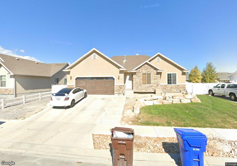
2133 Easter Dr Eagle Mountain, UT 84005
Estimated Value: $454,064 - $483,000
5
Beds
3
Baths
2,360
Sq Ft
$199/Sq Ft
Est. Value
About This Home
This home is located at 2133 Easter Dr, Eagle Mountain, UT 84005 and is currently estimated at $470,021, approximately $199 per square foot. 2133 Easter Dr is a home located in Utah County with nearby schools including Mountain Trails Elementary School, Frontier Middle School, and Cedar Valley High.
Ownership History
Date
Name
Owned For
Owner Type
Purchase Details
Closed on
Oct 13, 2017
Sold by
Souza Joseph
Bought by
Souza Joseph and Souza Cami Ann
Current Estimated Value
Purchase Details
Closed on
Jan 13, 2012
Sold by
Mathews Michael D and Mathews Ari J
Bought by
Mathews Michael D
Home Financials for this Owner
Home Financials are based on the most recent Mortgage that was taken out on this home.
Original Mortgage
$200,607
Interest Rate
3.85%
Mortgage Type
VA
Purchase Details
Closed on
Feb 13, 2007
Sold by
Mathews Michael D
Bought by
Mathews Michael D and Mathews Ari J
Home Financials for this Owner
Home Financials are based on the most recent Mortgage that was taken out on this home.
Original Mortgage
$199,244
Interest Rate
6.19%
Mortgage Type
VA
Create a Home Valuation Report for This Property
The Home Valuation Report is an in-depth analysis detailing your home's value as well as a comparison with similar homes in the area
Home Values in the Area
Average Home Value in this Area
Purchase History
| Date | Buyer | Sale Price | Title Company |
|---|---|---|---|
| Souza Joseph | -- | Inwest Title | |
| Souza Joseph | -- | Eagle Gate Title Ins | |
| Mathews Michael D | -- | None Available | |
| Mathews Michael D | -- | Select Title Insurance Agen | |
| Mathews Michael D | -- | Select Title Insurance Agen | |
| Patterson Construction | -- | Select Title Insurance Agen |
Source: Public Records
Mortgage History
| Date | Status | Borrower | Loan Amount |
|---|---|---|---|
| Previous Owner | Mathews Michael D | $200,607 | |
| Previous Owner | Mathews Michael D | $199,244 |
Source: Public Records
Tax History
| Year | Tax Paid | Tax Assessment Tax Assessment Total Assessment is a certain percentage of the fair market value that is determined by local assessors to be the total taxable value of land and additions on the property. | Land | Improvement |
|---|---|---|---|---|
| 2025 | $2,000 | $238,700 | -- | -- |
| 2024 | $2,000 | $216,150 | $0 | $0 |
| 2023 | $1,904 | $222,145 | $0 | $0 |
| 2022 | $2,102 | $239,580 | $0 | $0 |
| 2021 | $1,866 | $319,300 | $79,900 | $239,400 |
| 2020 | $1,776 | $296,700 | $74,000 | $222,700 |
| 2019 | $1,552 | $268,600 | $70,600 | $198,000 |
| 2018 | $1,512 | $247,500 | $60,500 | $187,000 |
| 2017 | $1,257 | $110,715 | $0 | $0 |
| 2016 | $1,196 | $98,560 | $0 | $0 |
| 2015 | $1,203 | $94,050 | $0 | $0 |
| 2014 | $1,173 | $90,530 | $0 | $0 |
Source: Public Records
Map
Nearby Homes
- 2079 E Porcupine Dr
- 2079 E Porcupine Dr Unit 4132
- 2057 E Porcupine Dr
- 2057 E Porcupine Dr Unit 4130
- 2111 E Hummingbird Dr Unit 4028
- 2145 E Hummingbird Dr
- 2145 E Hummingbird Dr Unit 4030
- 2127 E Hummingbird Dr
- 2127 E Hummingbird Dr Unit 4029
- 2095 E Hummingbird Dr Unit 4027
- 2146 E Shadow Dr
- 2079 E Hummingbird Dr
- 2122 E Hummingbird Dr
- 2074 E Porcupine Dr Unit 4151
- 2074 E Porcupine Dr
- 2106 E Hummingbird Dr
- 2106 E Hummingbird Dr Unit 4104
- 2259 E Sego Lily Dr Unit 486
- 2147 E Shadow Dr
- 2090 E Hummingbird Dr Unit 4103
- 2119 E Easter Dr
- 2119 Easter Dr
- 2119 E Easter Dr
- 2153 Easter Dr
- 2134 E Sunrise Dr
- 2134 Sunrise Dr
- 2148 Sunrise Dr
- 2120 Sunrise Dr
- 2120 E Sunrise Dr
- 2107 Easter Dr
- 2107 E Easter Dr
- 2132 Easter Dr
- 2144 Easter Dr
- 2144 E Easter Dr
- 2156 Sunrise Dr
- 2118 Easter Dr
- 2156 E Easter Dr
- 2156 Easter Dr
- 2108 Sunrise Dr
- 2093 Easter Dr
Your Personal Tour Guide
Ask me questions while you tour the home.