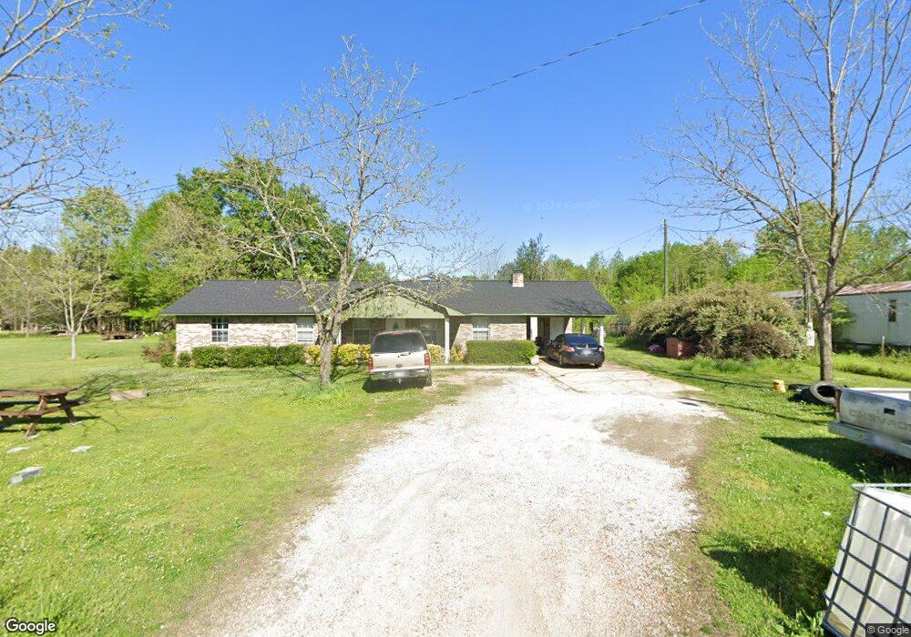
2133 Melton Bottom Rd West Point, MS 39773
Estimated Value: $218,548 - $287,000
3
Beds
--
Bath
2,096
Sq Ft
$121/Sq Ft
Est. Value
About This Home
This home is located at 2133 Melton Bottom Rd, West Point, MS 39773 and is currently estimated at $253,637, approximately $121 per square foot. 2133 Melton Bottom Rd is a home with nearby schools including East Side Elementary School, West Clay Elementary School, and Church Hill Elementary School.
Ownership History
Date
Name
Owned For
Owner Type
Purchase Details
Closed on
Apr 23, 2012
Sold by
Shelton Cornelia K
Bought by
Shelton Henry and Shelton Minnie R
Current Estimated Value
Create a Home Valuation Report for This Property
The Home Valuation Report is an in-depth analysis detailing your home's value as well as a comparison with similar homes in the area
Home Values in the Area
Average Home Value in this Area
Purchase History
| Date | Buyer | Sale Price | Title Company |
|---|---|---|---|
| Shelton Henry | -- | -- |
Source: Public Records
Tax History Compared to Growth
Tax History
| Year | Tax Paid | Tax Assessment Tax Assessment Total Assessment is a certain percentage of the fair market value that is determined by local assessors to be the total taxable value of land and additions on the property. | Land | Improvement |
|---|---|---|---|---|
| 2024 | $270 | $12,294 | $630 | $11,664 |
| 2023 | $526 | $12,137 | $630 | $11,507 |
| 2022 | $256 | $12,137 | $630 | $11,507 |
| 2021 | $256 | $12,137 | $630 | $11,507 |
| 2020 | $256 | $12,137 | $630 | $11,507 |
| 2019 | $230 | $11,869 | $630 | $11,239 |
| 2018 | $448 | $11,869 | $630 | $11,239 |
| 2017 | $448 | $11,869 | $630 | $11,239 |
| 2016 | $428 | $11,869 | $630 | $11,239 |
| 2015 | $139 | $4,671 | $630 | $4,041 |
| 2014 | $108 | $4,671 | $630 | $4,041 |
| 2013 | $108 | $4,671 | $630 | $4,041 |
Source: Public Records
Map
Nearby Homes
- 5 Clisby Rd
- 13 Clisby Rd
- 12 Clisby Rd
- 4 Clisby Rd
- 6 Clisby Rd
- 84 Waverly Dr
- 0 Dogwood Dr
- 0 Dogwood Dr (Lot 14) Unit 24-277
- 0 Dogwood Dr (Lot 20) Unit 24-278
- 0 Dogwood Dr (Lot 21) Unit 24-279
- 0 Pinkerton Rd
- 0 Waverly Dr
- Lot 31 Waverly Dr
- 64 Waverly Dr
- 43 Garden Cove
- 145 Waverly Dr
- 223 Waverly Dr
- 249 Waverly Dr
- 9 Scotland Yard
- 164 Deer Run Rd
- 2077 Melton Bottom Rd
- 114 Windmill Rd
- 1934 Melton Bottom Rd
- 1906 Melton Bottom Rd
- 290 Windmill Rd
- 4278 Charlie Shelton Rd
- 4300 Charlie Shelton Rd
- 4314 Charlie Shelton Rd
- 4380 Charlie Shelton Rd
- 295 Charlie Shelton Rd
- 4497 Charlie Shelton Rd
- 4478 Charlie Shelton Rd
- 431 Charlie Shelton Rd
- 1386 Melton Bottom Rd
- 580 Melton Bottom Rd
- 1271 Melton Bottom Rd
- 277 Clisby Rd