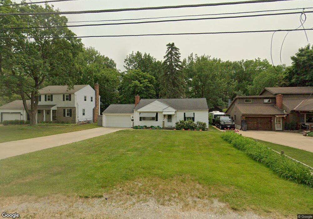
21345 Mastick Rd Cleveland, OH 44126
Estimated Value: $246,000 - $275,000
2
Beds
1
Bath
988
Sq Ft
$264/Sq Ft
Est. Value
About This Home
This home is located at 21345 Mastick Rd, Cleveland, OH 44126 and is currently estimated at $260,618, approximately $263 per square foot. 21345 Mastick Rd is a home located in Cuyahoga County with nearby schools including Gilles-Sweet Elementary School, Lewis F Mayer Middle School, and Fairview High School.
Ownership History
Date
Name
Owned For
Owner Type
Purchase Details
Closed on
Jul 1, 1999
Sold by
Eland Marcia R
Bought by
Eland James and Eland Marcia R
Current Estimated Value
Purchase Details
Closed on
Jan 18, 1994
Sold by
Mary Hansinger
Bought by
Hansinger Mary
Purchase Details
Closed on
Sep 25, 1978
Sold by
Hansinger Michael C
Bought by
Mary Hansinger
Purchase Details
Closed on
May 9, 1978
Sold by
Hansinger Michael C and Hansinger Mary
Bought by
Hansinger Michael C
Purchase Details
Closed on
Jan 1, 1975
Bought by
Hansinger Michael C and Hansinger Mary
Create a Home Valuation Report for This Property
The Home Valuation Report is an in-depth analysis detailing your home's value as well as a comparison with similar homes in the area
Home Values in the Area
Average Home Value in this Area
Purchase History
| Date | Buyer | Sale Price | Title Company |
|---|---|---|---|
| Eland James | -- | -- | |
| Hansinger Mary | -- | -- | |
| Mary Hansinger | -- | -- | |
| Hansinger Michael C | -- | -- | |
| Hansinger Michael C | -- | -- |
Source: Public Records
Tax History Compared to Growth
Tax History
| Year | Tax Paid | Tax Assessment Tax Assessment Total Assessment is a certain percentage of the fair market value that is determined by local assessors to be the total taxable value of land and additions on the property. | Land | Improvement |
|---|---|---|---|---|
| 2024 | $5,110 | $83,790 | $20,020 | $63,770 |
| 2023 | $3,665 | $54,010 | $13,440 | $40,570 |
| 2022 | $3,606 | $54,010 | $13,440 | $40,570 |
| 2021 | $3,670 | $54,010 | $13,440 | $40,570 |
| 2020 | $3,232 | $43,580 | $10,850 | $32,730 |
| 2019 | $2,879 | $124,500 | $31,000 | $93,500 |
| 2018 | $2,640 | $43,580 | $10,850 | $32,730 |
| 2017 | $2,514 | $36,680 | $10,920 | $25,760 |
| 2016 | $2,498 | $36,680 | $10,920 | $25,760 |
| 2015 | $2,382 | $36,680 | $10,920 | $25,760 |
| 2014 | $2,382 | $35,600 | $10,610 | $24,990 |
Source: Public Records
Map
Nearby Homes
- 20930 Mastick Rd
- 5951 Rockport Ln
- 22247 Mastick Rd
- 22534 Bard Ave
- 4710 Grayton Rd
- 22506 Sharon Ln
- 22503 Sandy Ln
- 4720 Grayton Rd
- 22045 Morton Ave
- 21437 Hillsdale Ave
- 21763 Hillsdale Ave
- 4627 W 223rd St
- 4464 W 224th St
- 22934 Mastick Rd Unit 102
- 19631 Thornridge Ave
- 4309 W 222nd St
- 4401 Fairview Park
- 4514 Orchard Rd
- 22895 Mastick Rd
- 4291 W 215th St
- 21375 Mastick Rd
- 21311 Mastick Rd
- 21387 Mastick Rd
- 21281 Mastick Rd
- 21399 Mastick Rd
- 21300 Mastick Rd
- 21350 Mastick Rd
- 21266 Mastick Rd
- 21415 Mastick Rd
- 21245 Mastick Rd
- 21465 Kings Hwy
- 21429 Mastick Rd
- 21435 Riviera Dr
- 21325 Queen Anns Way
- 21238 Mastick Rd
- 21380 Mastick Rd
- 21440 Riviera Dr
- 21215 Mastick Rd
- 21335 Queen Anns Way
- 21445 Mastick Rd