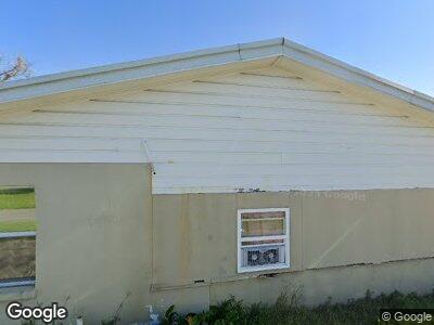
2135 Highway 182 E Morgan City, LA 70380
Estimated Value: $205,902 - $302,000
--
Bed
--
Bath
--
Sq Ft
0.56
Acres
About This Home
This home is located at 2135 Highway 182 E, Morgan City, LA 70380 and is currently estimated at $237,976. 2135 Highway 182 E is a home located in St. Mary Parish with nearby schools including Bayou Vista Elementary School, Berwick Junior High School, and Berwick High School.
Ownership History
Date
Name
Owned For
Owner Type
Purchase Details
Closed on
Jun 6, 2014
Sold by
Secretary Of Housing And Urban Developme
Bought by
Landry Joseph Berry
Current Estimated Value
Home Financials for this Owner
Home Financials are based on the most recent Mortgage that was taken out on this home.
Original Mortgage
$153,478
Interest Rate
4.27%
Mortgage Type
New Conventional
Purchase Details
Closed on
Sep 6, 2013
Sold by
Adcock Herschel C
Bought by
The Secretary Of Housing And Urban Devel
Create a Home Valuation Report for This Property
The Home Valuation Report is an in-depth analysis detailing your home's value as well as a comparison with similar homes in the area
Home Values in the Area
Average Home Value in this Area
Purchase History
| Date | Buyer | Sale Price | Title Company |
|---|---|---|---|
| Landry Joseph Berry | -- | -- | |
| Landry Joseph | -- | -- | |
| The Secretary Of Housing And Urban Devel | $177,747 | -- |
Source: Public Records
Mortgage History
| Date | Status | Borrower | Loan Amount |
|---|---|---|---|
| Open | Landry Joseph L | $138,563 | |
| Closed | Landry Joseph | $153,478 |
Source: Public Records
Tax History Compared to Growth
Tax History
| Year | Tax Paid | Tax Assessment Tax Assessment Total Assessment is a certain percentage of the fair market value that is determined by local assessors to be the total taxable value of land and additions on the property. | Land | Improvement |
|---|---|---|---|---|
| 2024 | $2,054 | $19,582 | $2,194 | $17,388 |
| 2023 | $1,856 | $18,002 | $2,194 | $15,808 |
| 2022 | $1,880 | $18,002 | $2,194 | $15,808 |
| 2021 | $1,880 | $18,002 | $2,194 | $15,808 |
| 2020 | $1,880 | $18,002 | $2,194 | $15,808 |
| 2019 | $1,744 | $17,107 | $2,194 | $14,913 |
| 2018 | $1,762 | $17,107 | $2,194 | $14,913 |
| 2017 | $1,725 | $17,107 | $2,194 | $14,913 |
| 2016 | $1,734 | $17,107 | $2,194 | $14,913 |
| 2015 | $957 | $14,910 | $0 | $14,910 |
| 2014 | $986 | $14,910 | $0 | $14,910 |
| 2013 | $763 | $12,747 | $0 | $12,747 |
Source: Public Records
Map
Nearby Homes
- 1933 Highway 182 E
- 1711 Cross St Unit 2
- 1210 Canal Rd
- 112 Myrtle St
- 147 Nini Rd
- 1444 Fairmont Ave
- 115 Venus St
- 1231 Columbus Ave
- 1016 Southeast Blvd
- 1086 9A-1 Victoria Riverside Rd
- 1086 9A-2 Victoria Riverside Rd
- 1308 Arbor Cir
- 508 Saturn Rd
- 913 Highway 182 E
- 3495 Highway 182
- 0 Hwy 90 Hwy Unit 2349233
- 203 Jones St Unit 10
- 221 Hogan St
- 211 Hogan St
- 175 Louisiana 182
- 2135 Highway 182 E
- 2135 Highway 182 E
- 2135 Highway 182 E
- 2135 Highway 182 W
- 2125 Highway 182 E
- 2201 Louisiana 182
- 555 Arcemont Ln
- 555 Arcemont Ln
- 555 Arcemont Ln
- 2201 Highway 182 E
- 522 Fanco Ln
- 514 Fanco Ln
- 616 Breezy Acres Ln
- 643 Landry Ln
- 631 Landry Ln
- 627 Landry Ln
- 621 Landry Ln
- 619 Suttoon Ln
- 627 Suttoon Ln
- 631 Suttoon Ln
