NOT LISTED FOR SALE

21351 Us Highway 20a West Unity, OH 43570

Estimated Value: $44,000 - $58,000

1.5 Acres
$34,409 Price per Acre
65,340 Sq Ft Lot

Last Sold August 02, 2022

Last sale price $25,000 $13 Per Sq Ft

Est. 106% increase in value since last sale

Current estimated payment $329/month

82 Days on Market

About This Lot

As of August 2022

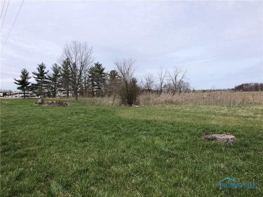
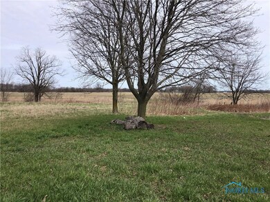
There is a 4" steel cased well (unsure of the condition) on the property, nice building lot.

Last Listed By

John Dye

Strong Real Estate Solutions License #2009002112 Listed on: 04/21/2022

Property Details

Property Type

  • Land

Est. Annual Taxes

  • $501

Year Built

  • 1920

Lot Details

  • 1.5 Acre Lot
  • Property fronts a highway
  • Lot Has A Rolling Slope
  • Few Trees

Schools

  • Mil W.U. Elementary School
  • Mil W.U. High School

Utilities

  • Well
  • Sewer Not Available

Listing and Financial Details

  • Assessor Parcel Number 074-040-02-008.000

Property Details

Property Type

Land

Est. Annual Taxes

$501

Year Built

1920

Lot Details

0

Listing Details

  • Topography: Rolling
  • Property Type: Land
  • Property Sub Type: Land
  • Lot Size Acres: 1.5
  • Lot Size: 65,340
  • Road Frontage Type: Highway
  • Road Surface Type: Paved
  • Inclusions: ,,
  • Subdivision Name: None
  • Property Sub Type Additional: Land
  • Special Features: None
  • Year Built: 1920

Interior Features

  • Possible Use: Single Family
  • Interior Amenities: None

Exterior Features

  • Lot Features: Buildable, Trees, Rolling Slope
  • Disclosures: Sellers Disclosure Not Available
  • Other Structures: None

Utilities

  • Utilities: None, Sewer Not Available
  • Sewer: None
  • Water Source: Well

Schools

  • Junior High Dist: Millcreek-West Unity

Lot Info

  • Development Status: Other
  • Parcel #: 074-040-02-008.000
  • ResoLotSizeUnits: Acres

MLS Schools

  • Elementary School: Mil W.U.
  • HighSchool: Mil W.U.

Ownership History

Date Name Owned For Owner Type

Purchase Details

Closed on
Nov 18, 2024
Sold by
Bell Larry C and Bell Gina L
Bought by
Altaffer Curtis L and Altaffer Edward L
Total Days on Market
82
Current Estimated Value
$51,613

Purchase Details

Listed on
Apr 21, 2022
Closed on
Aug 1, 2022
Sold by
Dye Mark L and Dye Debora A
Bought by
Bell Larry C
Seller's Agent
John Dye
Strong Real Estate Solutions
Buyer's Agent
John Dye
Strong Real Estate Solutions
List Price
$29,500
Sold Price
$25,000
Premium/Discount to List
-$4,500
-15.25%

Home Financials for this Owner

Home Financials are based on the most recent Mortgage that was taken out on this home.
Avg. Annual Appreciation
42.87%

Purchase Details

Closed on
Mar 11, 2022
Sold by
Williams County Land Reutilization Corpo
Bought by
Dye Mark L and Dye Debora A

Purchase Details

Closed on
Sep 29, 2017
Sold by
Newton Randy and Newton Teresa J
Bought by
Williams County Land Reutilization Corpo

Purchase Details

Closed on
Oct 26, 2005
Sold by
Whitman Corey D and Whitman Cherie L
Bought by
Newton Randy and Newton Teresa J

Home Financials for this Owner

Home Financials are based on the most recent Mortgage that was taken out on this home.
Original Mortgage
$18,720
Interest Rate
5.98%
Mortgage Type
Stand Alone Second

Purchase Details

Closed on
May 24, 1999
Sold by
Scribner Richard C
Bought by
Whitman Corey D

Purchase Details

Closed on
Jul 15, 1994
Sold by
Scribner Richard C And
Bought by
Scribner Richard C And

Range of Values:

Collateral Analytics

Collateral Analytics Collateral Analytics AVMs (Automated Valuation Model) employ a number of statistical approaches combined with neighborhood-specific comparable selection guarantees the most up-to-date and precise valuations.

Not Available

Collateral Analytics does not have data for the current month. Please view the chart for historical values.

ICE

ICE Mortgage Technology ICE Mortgage Technology’s AVM (Automated Valuation Model) is a state-of-the-art online residential property valuation tool that provides a quick and accurate estimate of the value of almost any home in the U.S.

Not Available

ICE Mortgage Technology does not have data for the current month. Please view the chart for historical values.

First American

First American First American Data & Analytics’ next-generation AVM combines unrivaled data assets with a blended ensemble of valuation models to produce highly accurate, reliable valuations you can trust.

Not Available

First American does not have data for the current month. Please view the chart for historical values.

Quantarium

Quantarium Quantarium’s valuation service, repeatedly proven the industry’s most accurate and comprehensive, is supercharged with a self-learning and auto-tuning AI engine that continually becomes smarter and more accurate as it processes daily inputs from the industry’s leading RE data lake.

Not Available

Quantarium does not have data for the current month. Please view the chart for historical values.

Average Value
Not Available
List Price
Sold Price
Create a Home Valuation Report for This Property
The Home Valuation Report is an in-depth analysis detailing your home's value as well as a comparison with similar homes in the area

Home Values in the Area

Source: Public Records

Average Home Value in this Area


Source: Public Records

Purchase History

Date Buyer Sale Price Title Company
Altaffer Curtis L $48,000 None Listed On Document
Bell Larry C -- Sostoi Martin W
Dye Mark L -- Breininger Spangler
Williams County Land Reutilization Corpo -- None Available
Newton Randy $93,600 None Available
Whitman Corey D $75,000 --
Scribner Richard C And $59,700 --
Source: Public Records

Mortgage History

Date Status Borrower Loan Amount
Previous Owner Williams County Land Reutilization Corpo $25,000
Previous Owner Newton Randy $18,720
Previous Owner Newton Randy $74,880
Source: Public Records

Property History

Date Event Price Change Sq Ft Price
08/02/2022 08/02/22 Sold $25,000 -15.3% $13 / Sq Ft
07/12/2022 07/12/22 Pending -- -- --
04/21/2022 04/21/22 For Sale $29,500 -- $15 / Sq Ft
Source: Northwest Ohio Real Estate Information Service (NORIS)

Tax History Compared to Growth

Source: Public Records

Tax History

Year Tax Paid Tax Assessment Tax Assessment Total Assessment is a certain percentage of the fair market value that is determined by local assessors to be the total taxable value of land and additions on the property. Land Improvement
2024 $501 $13,020 $3,150 $9,870
2023 $501 $2,490 $2,490 $0
2022 $90 $2,490 $2,490 $0
2021 $0 $2,490 $2,490 $0
2020 $97 $2,100 $2,100 $0
2019 $0 $2,100 $2,100 $0
2018 $608 $2,100 $2,100 $0
2017 $1,269 $27,200 $6,930 $20,270
2016 $1,404 $27,200 $6,930 $20,270
2015 $1,180 $27,200 $6,930 $20,270
2014 $1,180 $24,710 $6,300 $18,410
2013 $1,163 $24,710 $6,300 $18,410
Source: Public Records

Agents Affiliated with this Home

  • Section Image
See All Agents

Map

Source: Northwest Ohio Real Estate Information Service (NORIS)

MLS Number: 6085519

Northwest Ohio Real Estate Information Service (NORIS)

APN: 074-040-02-008.000