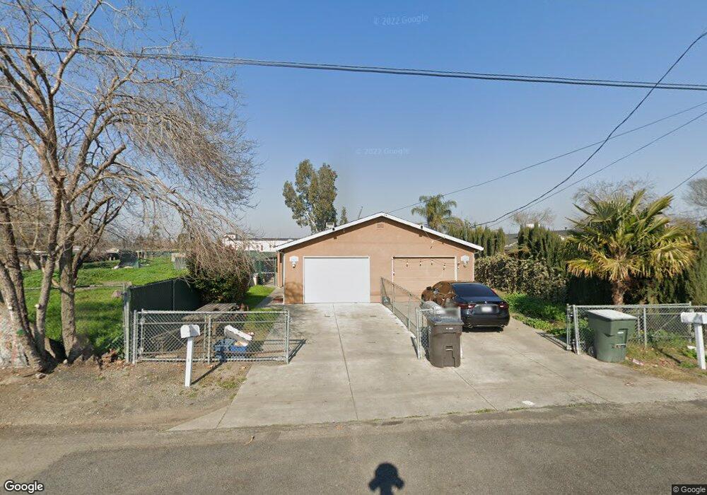
2139 Michael Ave Stockton, CA 95206
Kennedy NeighborhoodEstimated Value: $368,000 - $552,605
6
Beds
4
Baths
2,475
Sq Ft
$180/Sq Ft
Est. Value
About This Home
This home is located at 2139 Michael Ave, Stockton, CA 95206 and is currently estimated at $444,651, approximately $179 per square foot. 2139 Michael Ave is a home located in San Joaquin County with nearby schools including Monroe Elementary School, Alexander Hamilton Elementary, and Van Buren Elementary School.
Ownership History
Date
Name
Owned For
Owner Type
Purchase Details
Closed on
Aug 3, 2016
Sold by
Deutsche Bank National Trust Company
Bought by
Sacramento Paws Estate Llc
Current Estimated Value
Purchase Details
Closed on
Mar 17, 2016
Sold by
Sherman James
Bought by
Deutsche Bank National Trust Company
Purchase Details
Closed on
Jul 22, 2008
Sold by
Sherman James
Bought by
Dbph Enterprize
Purchase Details
Closed on
Jun 12, 2000
Sold by
Serna Joe
Bought by
Sherman James
Create a Home Valuation Report for This Property
The Home Valuation Report is an in-depth analysis detailing your home's value as well as a comparison with similar homes in the area
Home Values in the Area
Average Home Value in this Area
Purchase History
| Date | Buyer | Sale Price | Title Company |
|---|---|---|---|
| Sacramento Paws Estate Llc | $193,000 | Premium Title Of Ca Inc | |
| Deutsche Bank National Trust Company | $200,000 | Premium Title Tsg | |
| Dbph Enterprize | -- | None Available | |
| Sherman James | -- | Chicago Title Co |
Source: Public Records
Tax History
| Year | Tax Paid | Tax Assessment Tax Assessment Total Assessment is a certain percentage of the fair market value that is determined by local assessors to be the total taxable value of land and additions on the property. | Land | Improvement |
|---|---|---|---|---|
| 2025 | $2,969 | $223,497 | $46,420 | $177,077 |
| 2024 | $2,925 | $219,115 | $45,510 | $173,605 |
| 2023 | $2,864 | $214,819 | $44,618 | $170,201 |
| 2022 | $2,847 | $210,608 | $43,744 | $166,864 |
| 2021 | $2,744 | $206,480 | $42,887 | $163,593 |
| 2020 | $2,793 | $204,364 | $42,448 | $161,916 |
| 2019 | $2,783 | $200,358 | $41,616 | $158,742 |
| 2018 | $2,751 | $196,430 | $40,800 | $155,630 |
| 2017 | $2,766 | $192,579 | $40,000 | $152,579 |
| 2016 | $2,560 | $135,000 | $50,000 | $85,000 |
| 2015 | $1,550 | $100,000 | $35,000 | $65,000 |
| 2014 | $1,320 | $85,000 | $5,000 | $80,000 |
Source: Public Records
Map
Nearby Homes
- 2150 Michael Ave
- 2258 E Loomis Rd
- 2291 Amboy Ave
- 2278 E Loomis Rd
- 2297 Amboy Ave
- 2306 Amboy Ave
- 2318 Amboy Ave
- 2315 Amboy Ave
- 2318 E Loomis Rd
- 2328 E Loomis Rd
- 2348 E Loomis Rd
- 2348 E Amboy Ave
- 2348 Amboy Ave
- 3338 Zamora Way
- 2511 S Laurel St
- 1703 Ralph Ave
- 3243 Anne St
- 3260 Belleview Ave
- 3320 Volney St
- 2121 Scribner St
- 2151 Michael Ave
- 2157 Michael Ave
- 2125 Michael Ave
- 2169 Michael Ave
- 2105 Michael Ave
- 2132 Michael Ave
- 2148 Michael Ave
- 2120 Michael Ave
- 2175 Michael Ave
- 2079 Michael Ave
- 2067 Michael Ave
- 2110 Michael Ave
- 3020 S Laurel St
- 2186 Michael Ave
- 2162 Michael Ave
- 2180 Michael Ave
- 2156 Michael Ave
- 2136 Michael Ave
- 2964 S B St
- 2192 Michael Ave
Your Personal Tour Guide
Ask me questions while you tour the home.