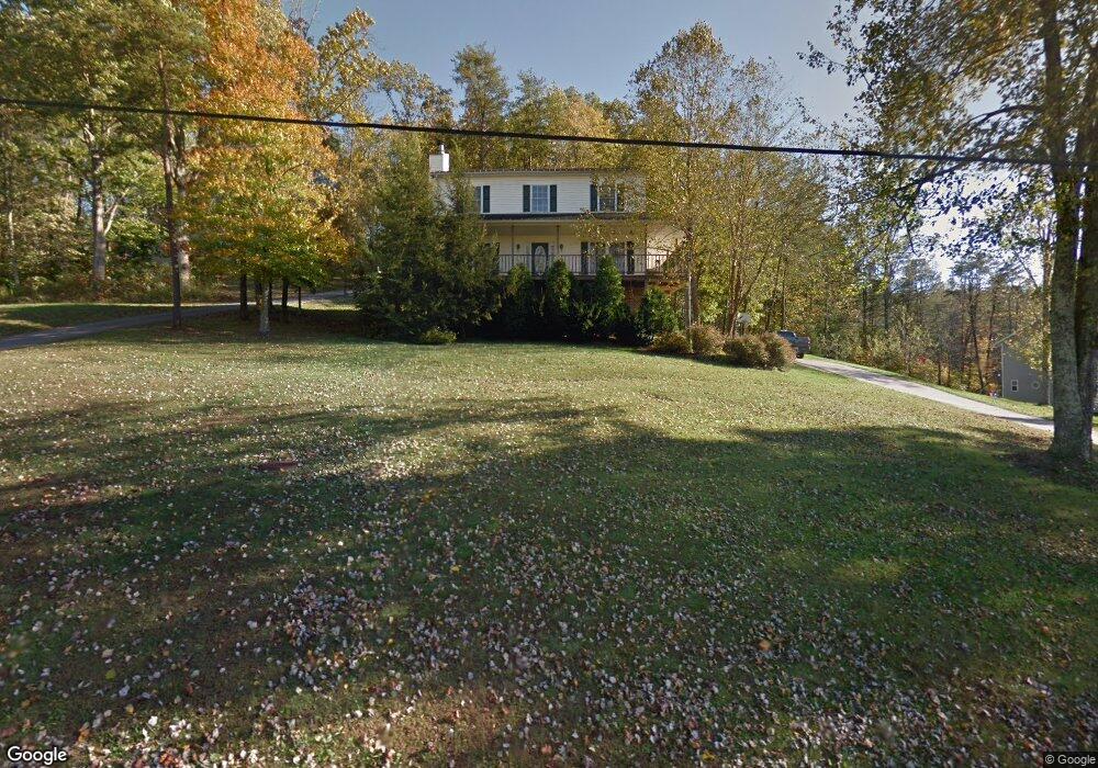
214 Cedar Dr Scott Depot, WV 25560
Estimated Value: $224,000 - $334,000
3
Beds
3
Baths
2,456
Sq Ft
$121/Sq Ft
Est. Value
About This Home
This home is located at 214 Cedar Dr, Scott Depot, WV 25560 and is currently estimated at $297,134, approximately $120 per square foot. 214 Cedar Dr is a home located in Putnam County with nearby schools including Teays Valley Christian School and Calvary Baptist Academy.
Ownership History
Date
Name
Owned For
Owner Type
Purchase Details
Closed on
Dec 16, 2022
Sold by
Sinclair Jeff
Bought by
Patton Hannah K
Current Estimated Value
Home Financials for this Owner
Home Financials are based on the most recent Mortgage that was taken out on this home.
Original Mortgage
$160,000
Outstanding Balance
$154,250
Interest Rate
6.31%
Estimated Equity
$142,884
Purchase Details
Closed on
Apr 6, 2022
Sold by
Hayes Roger D
Bought by
Sinclair Jeff
Purchase Details
Closed on
Apr 10, 2009
Sold by
Jividen Larry S and Burgess Emily H
Bought by
Hayes Roger D
Home Financials for this Owner
Home Financials are based on the most recent Mortgage that was taken out on this home.
Original Mortgage
$159,065
Interest Rate
4.93%
Mortgage Type
Purchase Money Mortgage
Create a Home Valuation Report for This Property
The Home Valuation Report is an in-depth analysis detailing your home's value as well as a comparison with similar homes in the area
Home Values in the Area
Average Home Value in this Area
Purchase History
| Date | Buyer | Sale Price | Title Company |
|---|---|---|---|
| Patton Hannah K | $200,000 | -- | |
| Sinclair Jeff | $180,000 | Edwards Klein Anderson & Shope | |
| Hayes Roger D | $162,000 | -- |
Source: Public Records
Mortgage History
| Date | Status | Borrower | Loan Amount |
|---|---|---|---|
| Open | Patton Hannah K | $160,000 | |
| Previous Owner | Hayes Roger D | $159,065 |
Source: Public Records
Tax History Compared to Growth
Tax History
| Year | Tax Paid | Tax Assessment Tax Assessment Total Assessment is a certain percentage of the fair market value that is determined by local assessors to be the total taxable value of land and additions on the property. | Land | Improvement |
|---|---|---|---|---|
| 2025 | $1,868 | $147,780 | $34,020 | $113,760 |
| 2024 | $1,868 | $139,200 | $34,020 | $105,180 |
| 2023 | $3,024 | $124,440 | $34,020 | $90,420 |
| 2022 | $1,338 | $130,980 | $34,020 | $96,960 |
| 2021 | $1,183 | $117,720 | $29,640 | $88,080 |
| 2020 | $1,150 | $115,080 | $22,260 | $92,820 |
| 2019 | $1,347 | $109,740 | $22,260 | $87,480 |
| 2018 | $1,341 | $108,960 | $22,260 | $86,700 |
| 2017 | $1,313 | $105,780 | $21,780 | $84,000 |
| 2016 | $1,317 | $105,600 | $25,440 | $80,160 |
| 2015 | $1,419 | $112,800 | $31,140 | $81,660 |
| 2014 | $1,219 | $96,960 | $16,020 | $80,940 |
Source: Public Records
Map
Nearby Homes
- 0 Tbd Hedrick Rd
- 149 Beechwood Estates
- 7732 Teays Valley Rd
- 5431 Teays Valley Rd
- TBD Hedrick Rd
- 107 Woodstone Dr
- 115 Rolling Meadows Dr
- 107 Countryside Rd
- 146 Tyler Way
- 200 Bent Tree Estates
- 116 Knights Ct
- 127 Litton Heights
- 111 Heritage Place
- 106 Heather Ct
- 75 Poinsettia Dr
- 0 Hedrick Rd Unit WVPU2000008
- 413 Lyman Ln
- Lot 12 Crooked Creek Rd
- 00 Hedrick Rd
- 600 Hedrick Rd
- 216 Cedar Dr
- 218 Cedar Dr
- 210 Cedar Dr
- 215 Cedar Dr
- 213 Cedar Dr
- 205 Cedar Dr
- 212 Cedar Dr
- 237 Cedar Dr
- 65 Red Cedar Dr
- 302 Red Cedar Dr
- 301 Red Cedar Dr
- 131 Cedar Dr
- 0 Cedar Dr
- 206 Cedar Dr
- 0 Red Cedar Dr Unit 157838
- 0 Red Cedar Dr Unit 212930
- 0 Red Cedar Dr Unit 224640
- 112 Cedar Dr
- 207 Cedar Dr
- 57 Spruce Dr