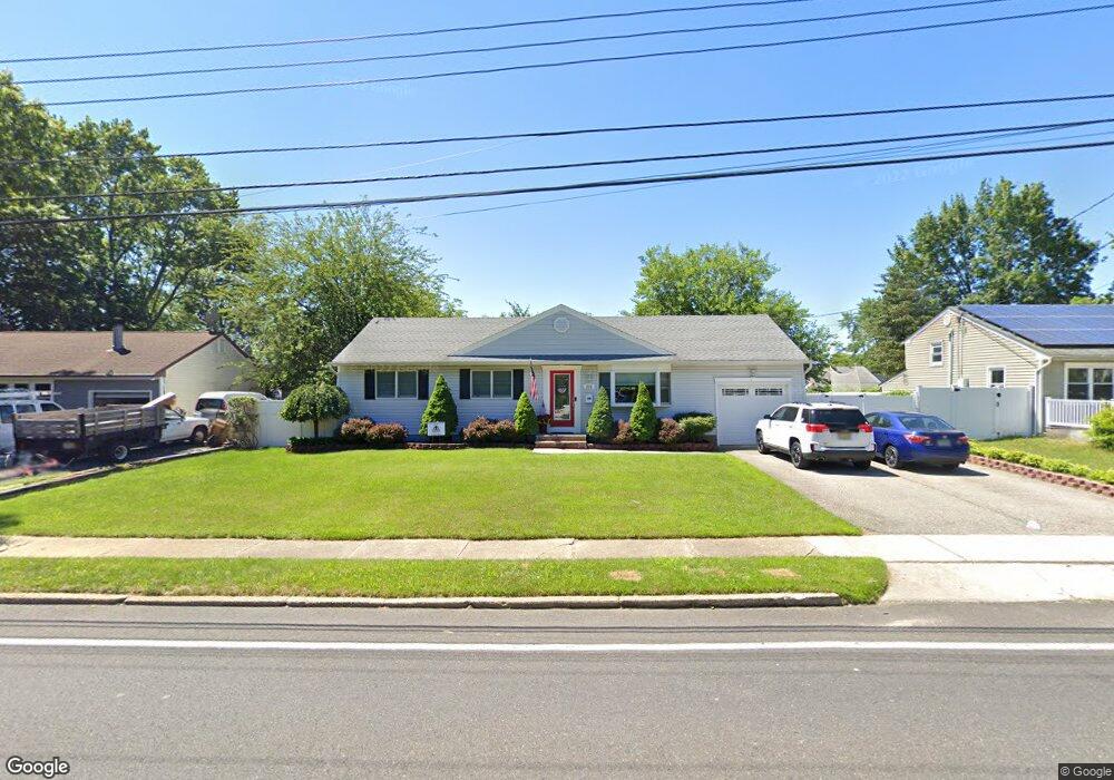
214 Cedar Grove Rd Toms River, NJ 08753
Estimated Value: $405,000 - $481,000
2
Beds
2
Baths
2,016
Sq Ft
$222/Sq Ft
Est. Value
About This Home
This home is located at 214 Cedar Grove Rd, Toms River, NJ 08753 and is currently estimated at $447,819, approximately $222 per square foot. 214 Cedar Grove Rd is a home located in Ocean County with nearby schools including St Joseph Grade School, Ambassador Christian Academy, and Donovan Catholic High School.
Ownership History
Date
Name
Owned For
Owner Type
Purchase Details
Closed on
Apr 13, 2005
Sold by
Winch Michael J and Winch Kathleen
Bought by
Gatti Dante P and Dorick Mary E
Current Estimated Value
Home Financials for this Owner
Home Financials are based on the most recent Mortgage that was taken out on this home.
Original Mortgage
$242,100
Outstanding Balance
$124,934
Interest Rate
5.78%
Mortgage Type
Fannie Mae Freddie Mac
Estimated Equity
$322,885
Purchase Details
Closed on
Nov 20, 1996
Sold by
Federal Home Loan Mortgage Corporation
Bought by
Winch Michael
Home Financials for this Owner
Home Financials are based on the most recent Mortgage that was taken out on this home.
Original Mortgage
$77,000
Interest Rate
7.83%
Create a Home Valuation Report for This Property
The Home Valuation Report is an in-depth analysis detailing your home's value as well as a comparison with similar homes in the area
Home Values in the Area
Average Home Value in this Area
Purchase History
| Date | Buyer | Sale Price | Title Company |
|---|---|---|---|
| Gatti Dante P | $269,000 | Multiple | |
| Winch Michael | $81,000 | -- |
Source: Public Records
Mortgage History
| Date | Status | Borrower | Loan Amount |
|---|---|---|---|
| Open | Gatti Dante P | $242,100 | |
| Previous Owner | Winch Michael | $77,000 |
Source: Public Records
Tax History Compared to Growth
Tax History
| Year | Tax Paid | Tax Assessment Tax Assessment Total Assessment is a certain percentage of the fair market value that is determined by local assessors to be the total taxable value of land and additions on the property. | Land | Improvement |
|---|---|---|---|---|
| 2025 | $5,159 | $283,300 | $91,000 | $192,300 |
| 2024 | $4,904 | $283,300 | $91,000 | $192,300 |
| 2023 | $4,728 | $283,300 | $91,000 | $192,300 |
| 2022 | $4,728 | $283,300 | $91,000 | $192,300 |
| 2021 | $4,777 | $190,700 | $88,400 | $102,300 |
| 2020 | $4,756 | $190,700 | $88,400 | $102,300 |
| 2019 | $4,550 | $190,700 | $88,400 | $102,300 |
| 2018 | $4,489 | $190,700 | $88,400 | $102,300 |
| 2017 | $4,451 | $190,700 | $88,400 | $102,300 |
| 2016 | $4,335 | $190,700 | $88,400 | $102,300 |
| 2015 | $4,171 | $190,700 | $88,400 | $102,300 |
| 2014 | $3,970 | $190,700 | $88,400 | $102,300 |
Source: Public Records
Map
Nearby Homes
- 507 Sloop Ct
- 308 Tradewinds Ave
- 830 Brookside Dr
- 241 Lester Rd
- 782 Bay Ave
- 308 Cedar Grove Rd
- 711 Bay Ave
- 696 Schoolhouse Ln
- 741 Spruce Hill Dr
- 927 Indian Hill Rd
- 939 Alden Dr
- 718 Arrow Dr
- 707 Cedar Point Ct
- 348 Cedar Grove Rd
- 679 Clifton Ave
- 855 Derry Dr
- 751 High Meadow Dr
- 846 Naryshkin Way
- 853 Naryshkin Way
- 73 Cedar Grove Rd
- 210 Cedar Grove Rd
- 218 Cedar Grove Rd
- 213 Carol Dr
- 209 Carol Dr
- 217 Carol Dr
- 206 Cedar Grove Rd
- 222 Cedar Grove Rd
- 205 Carol Dr
- 221 Carol Dr
- 211 Cedar Grove Rd
- 209 Cedar Grove Rd
- 202 Cedar Grove Rd
- 226 Cedar Grove Rd
- 500 Midship Dr
- 201 Carol Dr
- 225 Carol Dr
- 214 Carol Dr
- 210 Carol Dr
- 218 Carol Dr
- 206 Carol Dr