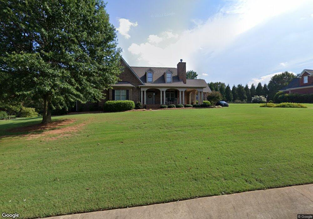
214 Dandelion Trail Anderson, SC 29621
Estimated Value: $618,031 - $876,000
3
Beds
4
Baths
3,400
Sq Ft
$206/Sq Ft
Est. Value
About This Home
This home is located at 214 Dandelion Trail, Anderson, SC 29621 and is currently estimated at $701,258, approximately $206 per square foot. 214 Dandelion Trail is a home located in Anderson County with nearby schools including North Pointe Elementary School, McCants Middle School, and T.L. Hanna High School.
Ownership History
Date
Name
Owned For
Owner Type
Purchase Details
Closed on
Jun 2, 2005
Sold by
Wilson Kenny Lane and Wilson Toni Lynn
Bought by
Gilreath Jeff D and Gilreath Cathy B
Current Estimated Value
Home Financials for this Owner
Home Financials are based on the most recent Mortgage that was taken out on this home.
Original Mortgage
$251,200
Outstanding Balance
$130,296
Interest Rate
5.66%
Mortgage Type
New Conventional
Estimated Equity
$570,962
Create a Home Valuation Report for This Property
The Home Valuation Report is an in-depth analysis detailing your home's value as well as a comparison with similar homes in the area
Home Values in the Area
Average Home Value in this Area
Purchase History
| Date | Buyer | Sale Price | Title Company |
|---|---|---|---|
| Gilreath Jeff D | $314,000 | -- |
Source: Public Records
Mortgage History
| Date | Status | Borrower | Loan Amount |
|---|---|---|---|
| Open | Gilreath Jeff D | $251,200 |
Source: Public Records
Tax History Compared to Growth
Tax History
| Year | Tax Paid | Tax Assessment Tax Assessment Total Assessment is a certain percentage of the fair market value that is determined by local assessors to be the total taxable value of land and additions on the property. | Land | Improvement |
|---|---|---|---|---|
| 2024 | $5,925 | $19,310 | $1,580 | $17,730 |
| 2023 | $5,925 | $19,310 | $1,580 | $17,730 |
| 2022 | $2,114 | $19,310 | $1,580 | $17,730 |
| 2021 | $1,882 | $15,910 | $1,400 | $14,510 |
| 2020 | $1,866 | $15,910 | $1,400 | $14,510 |
| 2019 | $1,866 | $15,910 | $1,400 | $14,510 |
| 2018 | $1,900 | $15,910 | $1,400 | $14,510 |
| 2017 | -- | $15,910 | $1,400 | $14,510 |
| 2016 | $1,753 | $15,300 | $1,320 | $13,980 |
| 2015 | $1,796 | $15,300 | $1,320 | $13,980 |
| 2014 | $1,791 | $15,300 | $1,320 | $13,980 |
Source: Public Records
Map
Nearby Homes
- 276 Silo Ridge Dr
- 286 Silo Ridge Dr
- 267 Silo Ridge Dr
- 231 Silo Ridge Dr
- 278 Silo Ridge Dr
- 284 Silo Ridge Dr
- 129 Silo Ridge Dr
- 288 Silo Ridge Dr
- 131 Silo Ridge Dr
- 274 Silo Ridge Dr
- 282 Silo Ridge Dr
- Lakehurst Plan at Silo Ridge
- Litchfield Plan at Silo Ridge
- Lochlan Plan at Silo Ridge
- 285 Silo Ridge Dr
- 216 Dandelion Trail
- 212 Dandelion Trail
- 98 C-6-86f
- 209 Dandelion Trail
- 211 Dandelion Trail
- 218 Dandelion Trail
- 210 Dandelion Trail
- 102 Wild Vine Path
- 102 C-6-86f
- 207 Dandelion Trail
- 213 Dandelion Trail
- 105 Grassy Knoll Way
- 220 Dandelion Trail
- 208 Dandelion Trail
- 103 Wild Vine Path
- 104 Wild Vine Path
- 00 Refuge Rd
- 14 and 15 Westminster Dr
- 000 E Side Hwy 76
- 000 Five Forks Rd