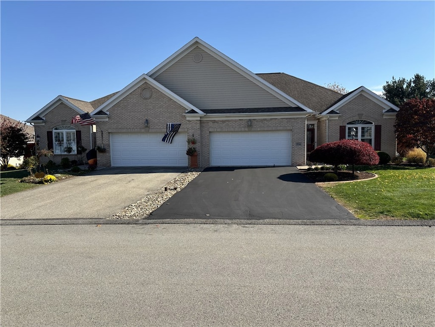
214 Denali Dr Unit 856B Latrobe, PA 15650
Estimated payment $2,533/month
Highlights
- Outdoor Pool
- Wood Flooring
- Double Pane Windows
- Greater Latrobe Junior High School Rated A-
- 2 Car Attached Garage
- Cooling Available
About This Home
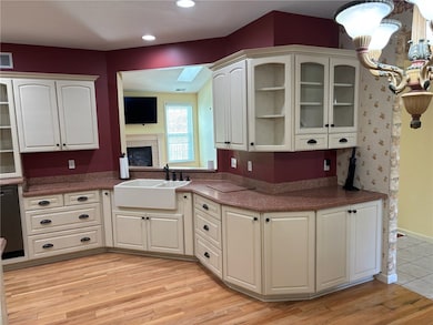
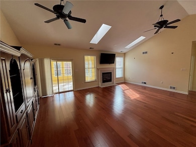
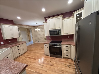
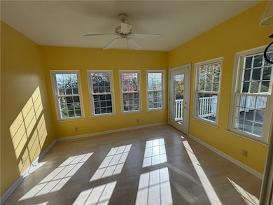
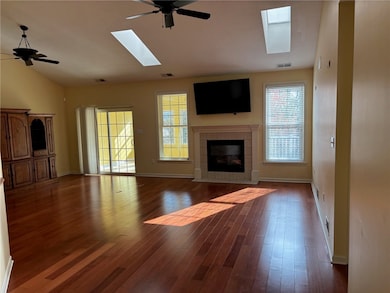
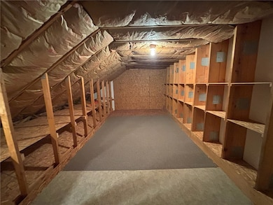
Beautifully updated patio home in Wimmerton with spacious & flexible floor plan, ideal for both comfortable everyday living or entertaining. The newly remodeled kitchen high end cabinetry, hardwood floors & chefs delight boasting newer stainless appliances & stylist farm sink. The open concept floor plan has a seamless flow between the kitchen, dining & living areas. The soaring vaulted ceiling in the great room has one of 5 fans throughout the house, 2 skylights, gas fireplace & open to a 13X11 sunroom filled with natural light. Off the sunroom is a large 24X12 maintenance free deck ideal for hosting large gatherings or just relaxing. The master suite offers two large closets, tray ceilings & remodeled bath. The large walk-up attic which is partially finished could be used as playroom, office or storage. Amenities include clubhouse, swimming pool & social activities & nestled in a private cul-de-sac.
Property Details
Home Type
- Condominium
Est. Annual Taxes
- $3,911
Year Built
- Built in 2005
HOA Fees
- $155 Monthly HOA Fees
Home Design
- Patio Home
- Brick Exterior Construction
Interior Spaces
- 1,871 Sq Ft Home
- Gas Fireplace
- Double Pane Windows
- Window Treatments
- Home Security System
Kitchen
- Stove
- Microwave
- Dishwasher
- Disposal
Flooring
- Wood
- Ceramic Tile
- Vinyl
Bedrooms and Bathrooms
- 3 Bedrooms
- 2 Full Bathrooms
Parking
- 2 Car Attached Garage
- Garage Door Opener
Pool
- Outdoor Pool
Utilities
- Cooling Available
- Forced Air Heating System
- Heating System Uses Gas
Community Details
Overview
- Wimmerton Place Subdivision
Amenities
- Public Transportation
Map
Home Values in the Area
Average Home Value in this Area
Tax History
| Year | Tax Paid | Tax Assessment Tax Assessment Total Assessment is a certain percentage of the fair market value that is determined by local assessors to be the total taxable value of land and additions on the property. | Land | Improvement |
|---|---|---|---|---|
| 2025 | $3,879 | $32,140 | $5,480 | $26,660 |
| 2024 | $3,879 | $32,140 | $5,480 | $26,660 |
| 2023 | $3,558 | $32,140 | $5,480 | $26,660 |
| 2022 | $3,558 | $32,140 | $5,480 | $26,660 |
| 2021 | $3,525 | $32,140 | $5,480 | $26,660 |
| 2020 | $3,469 | $32,140 | $5,480 | $26,660 |
| 2019 | $3,421 | $32,140 | $5,480 | $26,660 |
| 2018 | $3,405 | $32,140 | $5,480 | $26,660 |
| 2017 | $3,317 | $32,140 | $5,480 | $26,660 |
| 2016 | $777 | $32,140 | $5,480 | $26,660 |
| 2015 | $777 | $32,140 | $5,480 | $26,660 |
| 2014 | -- | $32,140 | $5,480 | $26,660 |
Property History
| Date | Event | Price | List to Sale | Price per Sq Ft |
|---|---|---|---|---|
| 11/04/2025 11/04/25 | For Sale | $390,000 | -- | $208 / Sq Ft |
Purchase History
| Date | Type | Sale Price | Title Company |
|---|---|---|---|
| Warranty Deed | $22,900 | None Available | |
| Deed | $205,700 | -- |
Mortgage History
| Date | Status | Loan Amount | Loan Type |
|---|---|---|---|
| Previous Owner | $150,000 | Unknown |
Source: West Penn Multi-List
MLS Number: 1729518
APN: 61-13-10-0-050
Disclaimer: Certain information contained herein is derived from information provided by parties other than Homes.com. All information provided is deemed reliable, but is not guaranteed to be accurate and should be independently verified.
![]() IDX information is provided exclusively for personal, non-commercial use, and may not be used for any purpose other than to identify prospective properties consumers may be interested in purchasing.
IDX information is provided exclusively for personal, non-commercial use, and may not be used for any purpose other than to identify prospective properties consumers may be interested in purchasing.
Information is deemed reliable but not guaranteed.
- 113 Mount Ranier Dr
- 402 S Shenandoah Dr Unit 805A
- 601 S Shenandoah Dr
- 1580 Lois Ln Unit Lot 11 C
- 1582 Lois Ln Unit Lot 11 B
- 359 Meadow Spring Rd
- 1113 B St
- 1108 B St
- 5634 State Route 981
- 710 Greyhound Ln
- 1187 Lakeview Dr
- 307 Persian Ln
- 632 Charles Houck Rd
- 227 Meadow Spring Rd
- 905 Terrace Dr
- 1213 Beech Dr
- 1213 W Fir Dr
- 400 Primrose Dr
- 139 Ice House Rd
- 5010 Linwood Ct
- 1007 Whitney Court Dr
- 112 W Monroe St Unit 112 and 114
- 203 Irving Ave
- 219 Thompson St Unit 1
- 2422 Ligonier St Unit 2B
- 412 Depot St
- 510 Main St Unit 510
- 114 Racquet Club Dr
- 4988 U S 30
- 221 Meadowview Dr
- 4907 Pennsylvania 982
- 714 Williamsburg Dr E
- 4974 Pa-982 Unit Everlasting
- 124 Toll House Rd
- 644 George St
- 535 New Alexandria Rd Unit 2
- 909 Highland Ave Unit B
- 618 Wirsing Ave Unit 614
- 103 E Pittsburgh St Unit 4E
- 103 E Pittsburgh St Unit 3W
