

214 Humboldt Ave Dorchester, MA 02121
Washington Park NeighborhoodEstimated payment $3,575/month
Highlights
- Property is near public transit
- Bonus Room
- Bathtub with Shower
- Wood Flooring
- Stainless Steel Appliances
- Patio
About This Home
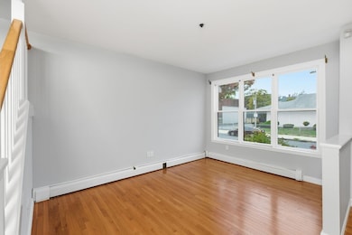
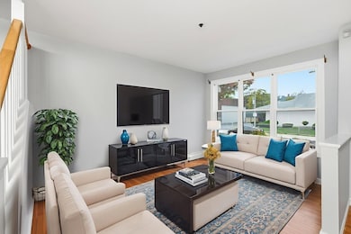
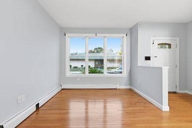
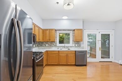
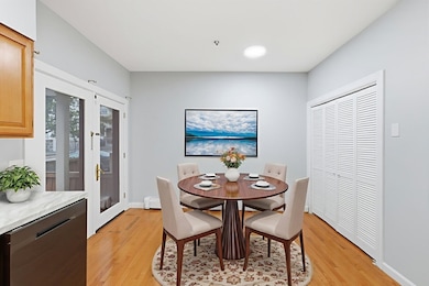
Nestled in one of Boston’s fastest-growing neighborhoods, this beautiful 3-level, 3-bedroom, 3-bath condo blends modern comfort and charm. Offering over 1,450 SF of flexible living space, it features hardwood floors throughout, abundant natural light, & an open layout. The eat-in kitchen features stainless steel appliances, a large pantry, and direct access to a private patio. The first level includes a spacious living room and a half bath. Upstairs, find two bedrooms, including the primary suite, a full bath, & laundry. The third level offers private living quarters with a 3⁄4 bath and a bonus room ideal for a home office or guest space. Assigned off-street parking space directly outside the unit. Close to Boston Latin Academy, Franklin Park, Longwood Medical, downtown, dining, shopping, and public transit. This turnkey condo delivers space, style, and unbeatable convenience. Recent updates include a freshly painted interior, updated lighting, and more. See it yourself today.
Townhouse Details
Home Type
- Townhome
Est. Annual Taxes
- $3,205
Year Built
- Built in 2004
Lot Details
- 1,472 Sq Ft Lot
- Two or More Common Walls
HOA Fees
- $417 Monthly HOA Fees
Home Design
- Entry on the 1st floor
- Shingle Roof
Interior Spaces
- 1,472 Sq Ft Home
- 3-Story Property
- Light Fixtures
- Bonus Room
Kitchen
- Range
- Microwave
- Dishwasher
- Stainless Steel Appliances
Flooring
- Wood
- Wall to Wall Carpet
- Laminate
- Ceramic Tile
Bedrooms and Bathrooms
- 3 Bedrooms
- Primary bedroom located on second floor
- Bathtub with Shower
- Separate Shower
Laundry
- Laundry on upper level
- Dryer
- Washer
Parking
- 1 Car Parking Space
- Paved Parking
- Open Parking
- Off-Street Parking
- Assigned Parking
Outdoor Features
- Patio
Location
- Property is near public transit
- Property is near schools
Utilities
- Window Unit Cooling System
- Baseboard Heating
- High Speed Internet
Listing and Financial Details
- Assessor Parcel Number W:12 P:02221 S:026,4470933
Community Details
Overview
- Association fees include water, sewer, ground maintenance, snow removal, trash
- 16 Units
Amenities
- Shops
Recreation
- Park
Pet Policy
- Pets Allowed
Map
Home Values in the Area
Average Home Value in this Area
Tax History
| Year | Tax Paid | Tax Assessment Tax Assessment Total Assessment is a certain percentage of the fair market value that is determined by local assessors to be the total taxable value of land and additions on the property. | Land | Improvement |
|---|---|---|---|---|
| 2025 | $3,205 | $276,800 | $0 | $276,800 |
| 2024 | $2,873 | $263,600 | $0 | $263,600 |
| 2023 | $2,696 | $251,000 | $0 | $251,000 |
| 2022 | $2,600 | $239,000 | $0 | $239,000 |
| 2021 | $2,428 | $227,600 | $0 | $227,600 |
| 2020 | $2,289 | $216,800 | $0 | $216,800 |
| 2019 | $2,177 | $206,500 | $0 | $206,500 |
| 2018 | $2,061 | $196,700 | $0 | $196,700 |
| 2017 | $1,984 | $187,300 | $0 | $187,300 |
| 2016 | $1,962 | $178,400 | $0 | $178,400 |
| 2015 | $2,057 | $169,900 | $0 | $169,900 |
| 2014 | $2,035 | $161,800 | $0 | $161,800 |
Property History
| Date | Event | Price | List to Sale | Price per Sq Ft |
|---|---|---|---|---|
| 10/29/2025 10/29/25 | For Sale | $549,000 | -- | $373 / Sq Ft |
Purchase History
| Date | Type | Sale Price | Title Company |
|---|---|---|---|
| Warranty Deed | $109,500 | -- |
Mortgage History
| Date | Status | Loan Amount | Loan Type |
|---|---|---|---|
| Open | $84,300 | Purchase Money Mortgage |
Source: MLS Property Information Network (MLS PIN)
MLS Number: 73449311
APN: ROXB-000000-000012-002221-000026
Disclaimer: Certain information contained herein is derived from information provided by parties other than Homes.com. All information provided is deemed reliable, but is not guaranteed to be accurate and should be independently verified.
![]() The property listing data and information, or the Images, set forth herein were provided to MLS Property Information Network, Inc. from third party sources, including sellers, lessors and public records, and were compiled by MLS Property Information Network, Inc. The property listing data and information, and the Images, are for the personal, non-commercial use of consumers having a good faith interest in purchasing or leasing listed properties of the type displayed to them and may not be used for any purpose other than to identify prospective properties which such consumers may have a good faith interest in purchasing or leasing. MLS Property Information Network, Inc. and its subscribers disclaim any and all representations and warranties as to the accuracy of the property listing data and information, or as to the accuracy of any of the Images, set forth herein.
The property listing data and information, or the Images, set forth herein were provided to MLS Property Information Network, Inc. from third party sources, including sellers, lessors and public records, and were compiled by MLS Property Information Network, Inc. The property listing data and information, and the Images, are for the personal, non-commercial use of consumers having a good faith interest in purchasing or leasing listed properties of the type displayed to them and may not be used for any purpose other than to identify prospective properties which such consumers may have a good faith interest in purchasing or leasing. MLS Property Information Network, Inc. and its subscribers disclaim any and all representations and warranties as to the accuracy of the property listing data and information, or as to the accuracy of any of the Images, set forth herein.
- 75 Ruthven St
- 136-138 Homestead St
- 78 Hutchings St Unit 1
- 164 Ruthven St Unit 1
- 25 Hutchings St
- 9 Abbotsford St Unit 1
- 4 Ruthven St
- 28 Wabon St
- 7 Waumbeck St Unit 3
- 4 Wyoming St Unit 2
- 99 Harrishof St
- 495 Warren St
- 151 Townsend St
- 32 Hartwell St
- 41 W Walnut Park
- 476 Warren St
- 27 Dixwell St Unit 11
- 27 Dixwell St Unit 12
- 27 Dixwell St Unit 4
- 1-3 Glines Ave
- 81 Ruthven St Unit 1
- 111 Hutchings St Unit 2
- 10 Ruthven Park Unit 2
- 74 Ruthven St Unit 1
- 176 Humboldt Ave Unit 2
- 146 Homestead St Unit 146
- 35 Abbotsford St Unit 3
- 35 Abbotsford St
- 17 Park View St
- 19 Park View St Unit 2
- 28 Brookledge St Unit 1
- 76 Seaver St Unit 2
- 100 Seaver St Unit 12B
- 100 Seaver St Unit 2
- 85 Abbotsford St Unit 1
- 96 Waumbeck St
- 9A Ruthven St Unit 2
- 96 Waumbeck St Unit 1
- 96 Waumbeck St
- 23 Wabeno St Unit 3rd Floor
