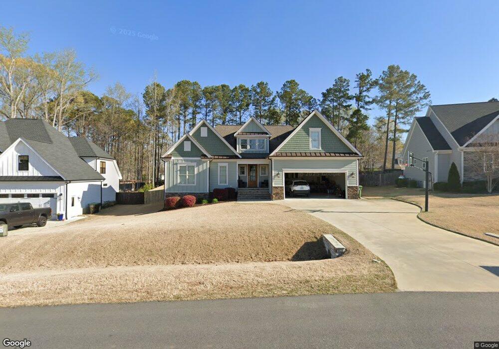
214 Reese Dr Unit Lot 15 Willow Spring(s), NC 27592
Pleasant Grove NeighborhoodEstimated Value: $578,000 - $641,000
3
Beds
4
Baths
2,810
Sq Ft
$217/Sq Ft
Est. Value
About This Home
This home is located at 214 Reese Dr Unit Lot 15, Willow Spring(s), NC 27592 and is currently estimated at $610,326, approximately $217 per square foot. 214 Reese Dr Unit Lot 15 is a home located in Johnston County with nearby schools including Dixon Road Elementary School, McGee's Crossroads Middle School, and West Johnston High School.
Ownership History
Date
Name
Owned For
Owner Type
Purchase Details
Closed on
Jul 15, 2020
Sold by
Too Construction Company Inc
Bought by
Surrett Carl Eugene and Surrett Jamie Galloway
Current Estimated Value
Home Financials for this Owner
Home Financials are based on the most recent Mortgage that was taken out on this home.
Original Mortgage
$427,764
Outstanding Balance
$379,313
Interest Rate
3.1%
Mortgage Type
VA
Estimated Equity
$231,013
Purchase Details
Closed on
Mar 26, 2019
Sold by
Reese Construction Llc
Bought by
Too Construction Company Inc
Home Financials for this Owner
Home Financials are based on the most recent Mortgage that was taken out on this home.
Original Mortgage
$239,000
Interest Rate
4.3%
Mortgage Type
New Conventional
Create a Home Valuation Report for This Property
The Home Valuation Report is an in-depth analysis detailing your home's value as well as a comparison with similar homes in the area
Home Values in the Area
Average Home Value in this Area
Purchase History
| Date | Buyer | Sale Price | Title Company |
|---|---|---|---|
| Surrett Carl Eugene | $413,000 | None Available | |
| Too Construction Company Inc | $120,000 | None Available |
Source: Public Records
Mortgage History
| Date | Status | Borrower | Loan Amount |
|---|---|---|---|
| Open | Surrett Carl Eugene | $427,764 | |
| Previous Owner | Too Construction Company Inc | $239,000 |
Source: Public Records
Tax History Compared to Growth
Tax History
| Year | Tax Paid | Tax Assessment Tax Assessment Total Assessment is a certain percentage of the fair market value that is determined by local assessors to be the total taxable value of land and additions on the property. | Land | Improvement |
|---|---|---|---|---|
| 2025 | $3,578 | $563,430 | $75,000 | $488,430 |
| 2024 | $3,500 | $432,080 | $60,000 | $372,080 |
| 2023 | $3,392 | $432,080 | $60,000 | $372,080 |
| 2022 | $3,318 | $409,600 | $60,000 | $349,600 |
| 2021 | $3,104 | $383,170 | $60,000 | $323,170 |
| 2020 | $504 | $60,000 | $60,000 | $0 |
Source: Public Records
Map
Nearby Homes
- 50 Linden Ct
- 169 Mount Pleasant Rd
- 18 Pawnee Place
- 96 Oak Fern Ln
- 109 Shallow Creek Crossing
- 386 Artic Cir
- 368 Artic Cir
- 291 Artic Cir
- 111 Artic Cir
- Roanoke Plan at Brant Station
- Fontana Plan at Brant Station
- Avenel II Plan at Brant Station
- 181 Fawn Hill Ct
- 75 Fawn Hill Ct
- 19 Marie Ct
- 48 Banbury Ct
- 834 November Ln
- 895 November Ln
- 595 Durwood Dr
- 618 Durwood Dr
- 215 Reese Dr Unit Lot 44
- 200 Reese Dr
- 200 Reese Dr Unit Lot 14
- 230 Reese Dr
- 230 Reese Dr Unit Lot 16
- 257 Reese Dr Unit Lot 43
- 175 Reese Dr
- 175 Reese Dr Unit Lot 45
- 188 Reese Dr Unit Lot 13
- 174 Reese Dr
- 244 Reese Dr Unit Lot 17
- 262 Reese Dr Unit Lot 18
- 213 Tamworth Dr
- 217 Tamworth Dr
- 158 Reese Dr Unit Lot 11
- 278 Reese Dr Unit Lot 19
- 287 Reese Dr Unit Lot 41
- 142 Reese Dr
- 142 Reese Dr Unit Lot 10
- 209 Tamworth Dr