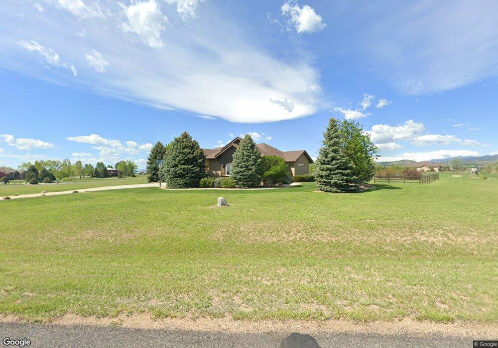
2141 Shoreside Dr Berthoud, CO 80513
Estimated Value: $1,474,000 - $2,351,000
4
Beds
5
Baths
4,700
Sq Ft
$401/Sq Ft
Est. Value
About This Home
This home is located at 2141 Shoreside Dr, Berthoud, CO 80513 and is currently estimated at $1,883,291, approximately $400 per square foot. 2141 Shoreside Dr is a home located in Larimer County with nearby schools including Berthoud Elementary School, Turner Middle School, and Berthoud High School.
Ownership History
Date
Name
Owned For
Owner Type
Purchase Details
Closed on
May 4, 2023
Sold by
Barr Diran
Bought by
Diran Barr Trust
Current Estimated Value
Purchase Details
Closed on
Dec 29, 2006
Sold by
Eckert Michael J and Eckert Marianne
Bought by
Barr Diran
Home Financials for this Owner
Home Financials are based on the most recent Mortgage that was taken out on this home.
Original Mortgage
$755,000
Interest Rate
6.2%
Mortgage Type
Purchase Money Mortgage
Purchase Details
Closed on
Jan 21, 2005
Sold by
Bondurant Kenneth F
Bought by
Eckert Michael J and Eckert Marianne
Home Financials for this Owner
Home Financials are based on the most recent Mortgage that was taken out on this home.
Original Mortgage
$926,000
Interest Rate
5.71%
Mortgage Type
Construction
Purchase Details
Closed on
Jun 13, 2001
Sold by
Paradise Valley Llc
Bought by
Bondurant Kenneth F
Create a Home Valuation Report for This Property
The Home Valuation Report is an in-depth analysis detailing your home's value as well as a comparison with similar homes in the area
Home Values in the Area
Average Home Value in this Area
Purchase History
| Date | Buyer | Sale Price | Title Company |
|---|---|---|---|
| Diran Barr Trust | -- | None Listed On Document | |
| Barr Diran | $996,000 | Stewart Title | |
| Eckert Michael J | $210,000 | -- | |
| Bondurant Kenneth F | $181,400 | -- |
Source: Public Records
Mortgage History
| Date | Status | Borrower | Loan Amount |
|---|---|---|---|
| Previous Owner | Barr Diran | $755,000 | |
| Previous Owner | Eckert Michael J | $926,000 |
Source: Public Records
Tax History Compared to Growth
Tax History
| Year | Tax Paid | Tax Assessment Tax Assessment Total Assessment is a certain percentage of the fair market value that is determined by local assessors to be the total taxable value of land and additions on the property. | Land | Improvement |
|---|---|---|---|---|
| 2025 | $8,991 | $114,302 | $26,465 | $87,837 |
| 2024 | $9,256 | $114,302 | $26,465 | $87,837 |
| 2022 | $6,943 | $80,495 | $15,012 | $65,483 |
| 2021 | $7,136 | $82,811 | $15,444 | $67,367 |
| 2020 | $6,187 | $71,779 | $12,870 | $58,909 |
| 2019 | $6,098 | $71,779 | $12,870 | $58,909 |
| 2018 | $5,533 | $62,215 | $12,960 | $49,255 |
| 2017 | $4,823 | $62,215 | $12,960 | $49,255 |
| 2016 | $5,038 | $63,011 | $13,134 | $49,877 |
| 2015 | $5,004 | $63,010 | $13,130 | $49,880 |
| 2014 | -- | $62,640 | $13,130 | $49,510 |
Source: Public Records
Map
Nearby Homes
- 2102 Shoreside Dr
- 2366 Shoreside Dr
- 1822 Quarter Ln
- 1932 N County Road 23
- 4707 Lonetree Dr
- 2517 Southwind Rd
- 4616 Lonetree Dr
- 2672 Bluewater Rd
- 2598 Bluewater Rd
- 2552 Bluewater Rd
- 2622 Bluewater Rd
- 2654 Big Creek Ct
- 2668 Big Creek Ct
- 2622 Big Creek Ct
- 2696 Bluewater Rd
- 2732 Bluewater Rd
- 2554 Southwind Rd
- 2568 Southwind Rd
- 2669 Southwind Rd
- 2682 Southwind Rd
- 2235 Shoreside Dr
- 2140 Shoreside Dr
- 2090 Luvesta Ct
- 2103 Shoreside Dr
- 2057 Doyle Dr
- 2106 Luvesta Ct
- 2128 Shoreside Dr
- 2248 Shoreside Dr
- 2261 Shoreside Dr
- 2063 Doyle Dr
- 2091 Luvesta Ct
- 2114 Shoreside Dr
- 2262 Shoreside Dr
- 2069 Doyle Dr
- 2110 Doyle Dr
- 2224 Doyle Dr
- 2075 Doyle Dr
- 2353 Shoreside Dr
- 2079 Doyle Dr
- 2083 Doyle Dr