Estimated Value: $206,165 - $244,000
3
Beds
1
Bath
1,373
Sq Ft
$164/Sq Ft
Est. Value
About This Home
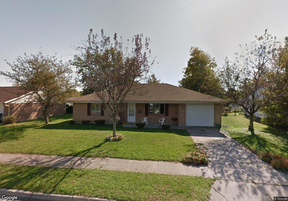
This home is located at 2145 Dundee Dr, Xenia, OH 45385 and is currently estimated at $225,291, approximately $164 per square foot. 2145 Dundee Dr is a home located in Greene County with nearby schools including Xenia High School, Summit Academy Community School for Alternative Learners - Xenia, and Legacy Christian Academy.
Ownership History
Date
Name
Owned For
Owner Type
Purchase Details
Closed on
Jan 13, 2006
Sold by
Greene Metropolitan Housing Authority
Bought by
Mckee Sharon S
Current Estimated Value
Home Financials for this Owner
Home Financials are based on the most recent Mortgage that was taken out on this home.
Original Mortgage
$25,850
Outstanding Balance
$14,658
Interest Rate
6.42%
Mortgage Type
Unknown
Estimated Equity
$210,633
Create a Home Valuation Report for This Property
The Home Valuation Report is an in-depth analysis detailing your home's value as well as a comparison with similar homes in the area
Home Values in the Area
Average Home Value in this Area
Purchase History
| Date | Buyer | Sale Price | Title Company |
|---|---|---|---|
| Mckee Sharon S | $27,200 | None Available |
Source: Public Records
Mortgage History
| Date | Status | Borrower | Loan Amount |
|---|---|---|---|
| Open | Mckee Sharon S | $25,850 |
Source: Public Records
Tax History Compared to Growth
Tax History
| Year | Tax Paid | Tax Assessment Tax Assessment Total Assessment is a certain percentage of the fair market value that is determined by local assessors to be the total taxable value of land and additions on the property. | Land | Improvement |
|---|---|---|---|---|
| 2024 | $2,259 | $54,190 | $12,610 | $41,580 |
| 2023 | $2,259 | $54,190 | $12,610 | $41,580 |
| 2022 | $1,880 | $38,450 | $7,420 | $31,030 |
| 2021 | $1,906 | $38,450 | $7,420 | $31,030 |
| 2020 | $1,824 | $38,450 | $7,420 | $31,030 |
| 2019 | $1,941 | $38,510 | $7,250 | $31,260 |
| 2018 | $1,948 | $38,510 | $7,250 | $31,260 |
| 2017 | $1,791 | $38,510 | $7,250 | $31,260 |
| 2016 | $1,792 | $34,770 | $7,250 | $27,520 |
| 2015 | $1,797 | $34,770 | $7,250 | $27,520 |
| 2014 | $1,719 | $34,770 | $7,250 | $27,520 |
Source: Public Records
Map
Nearby Homes
- 2499 Jenny Marie Dr
- 2540 Jenny Marie Dr
- 2421 Louisiana Dr
- 2540 Cornwall Dr
- 1107 Arkansas Dr
- 1255 Colorado Dr
- 0 Berkshire Dr Unit 942854
- 2345 Tennessee Dr
- 1908 Whitt St
- 1866 Roxbury Dr
- 1829 Gayhart Dr
- 2784 Greystoke Dr
- 2257 Maryland Dr
- 1769 Gayhart Dr
- 1403 Texas Dr
- 2692 Kingman Dr
- 2705 Tennessee Dr
- 2144 Tandem Dr
- 2821 Raxit Ct
- 1318 Prem Place
- 2159 Dundee Dr
- 2129 Dundee Dr
- 2173 Dundee Dr
- 2320 Commonwealth Dr
- 2405 Pembury Dr
- 2290 Commonwealth Dr
- 2304 Commonwealth Dr
- 2160 Dundee Dr
- 2371 Cornwall Dr
- 2174 Dundee Dr
- 2385 Cornwall Dr
- 2268 Commonwealth Dr
- 2399 Cornwall Dr
- 2385 Pembury Dr
- 2364 Pembury Dr
- 2252 Commonwealth Dr
- 2188 Dundee Dr
- 2333 Commonwealth Dr
- 2325 Commonwealth Dr
- 2317 Commonwealth Dr