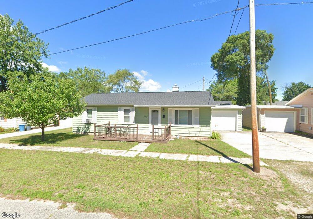
215 E Bank Ave Oscoda, MI 48750
Estimated Value: $110,471 - $125,000
2
Beds
1
Bath
1,008
Sq Ft
$117/Sq Ft
Est. Value
About This Home
This home is located at 215 E Bank Ave, Oscoda, MI 48750 and is currently estimated at $118,368, approximately $117 per square foot. 215 E Bank Ave is a home located in Iosco County with nearby schools including Richardson Elementary School and Oscoda Area High School.
Ownership History
Date
Name
Owned For
Owner Type
Purchase Details
Closed on
Oct 3, 2022
Sold by
Hugh James Vantol And Barbara Vantol Tru
Bought by
Loveland Kimberly A
Current Estimated Value
Home Financials for this Owner
Home Financials are based on the most recent Mortgage that was taken out on this home.
Original Mortgage
$63,200
Outstanding Balance
$60,603
Interest Rate
5.55%
Mortgage Type
New Conventional
Estimated Equity
$57,765
Purchase Details
Closed on
Apr 26, 2018
Sold by
Vantol Hugh J and Vantol Barbara A
Bought by
Hugh Hugh J and Hugh Barbara A
Create a Home Valuation Report for This Property
The Home Valuation Report is an in-depth analysis detailing your home's value as well as a comparison with similar homes in the area
Home Values in the Area
Average Home Value in this Area
Purchase History
| Date | Buyer | Sale Price | Title Company |
|---|---|---|---|
| Loveland Kimberly A | $79,000 | Landmark Title | |
| Hugh Hugh J | -- | -- |
Source: Public Records
Mortgage History
| Date | Status | Borrower | Loan Amount |
|---|---|---|---|
| Open | Loveland Kimberly A | $63,200 |
Source: Public Records
Tax History Compared to Growth
Tax History
| Year | Tax Paid | Tax Assessment Tax Assessment Total Assessment is a certain percentage of the fair market value that is determined by local assessors to be the total taxable value of land and additions on the property. | Land | Improvement |
|---|---|---|---|---|
| 2025 | $1,643 | $47,400 | $47,400 | $0 |
| 2024 | $1,505 | $42,500 | $0 | $0 |
| 2023 | $1,052 | $34,100 | $34,100 | $0 |
| 2022 | $1,064 | $26,100 | $26,100 | $0 |
| 2021 | $1,029 | $25,000 | $25,000 | $0 |
| 2020 | $1,002 | $24,200 | $24,200 | $0 |
| 2019 | $989 | $23,700 | $23,700 | $0 |
| 2018 | $968 | $26,200 | $26,200 | $0 |
| 2017 | $894 | $28,100 | $28,100 | $0 |
| 2016 | $871 | $28,100 | $0 | $0 |
| 2015 | -- | $26,300 | $0 | $0 |
| 2014 | -- | $21,400 | $0 | $0 |
| 2013 | -- | $22,700 | $0 | $0 |
Source: Public Records
Map
Nearby Homes
- 205 E Water Ave Unit 16
- 200 Pack St
- 205 Pack St
- 203 Pack St
- 119 W Dwight Ave
- 4664 Lindholm Rd
- 209 E Mill St
- 112 1st St N
- 430 S State St
- 281 Chrysler Rd Unit 14
- 200 Harbor St
- 0000 Chester Rd
- 879 S State St
- 5320 Pine St
- 891 S State St
- 313 Forest St
- VL Vaughan Trail
- 0 Vl Vaughn Trail
- 324 Old Us 23
- 5484 Cedar Lake Rd