Estimated payment $1,888/month
Highlights
- Horses Allowed On Property
- Farm
- Granite Countertops
- Bernita Hughes Elementary School Rated A
- High Ceiling
- No HOA
About This Home
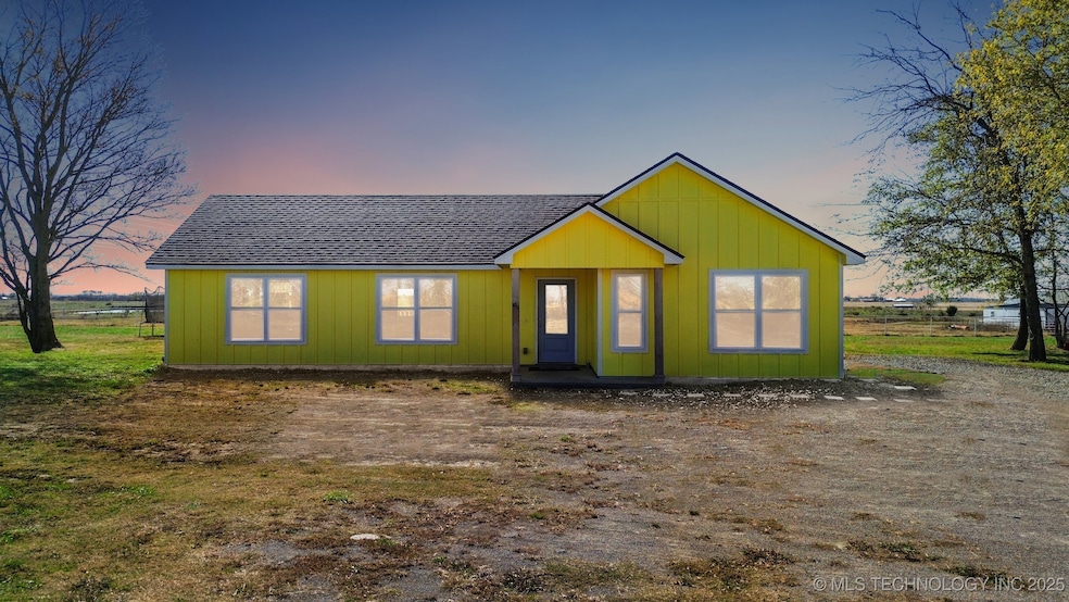
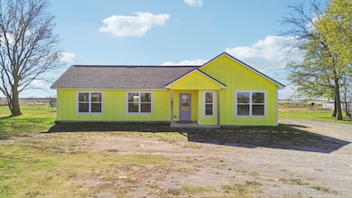
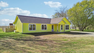
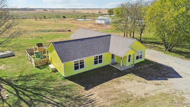
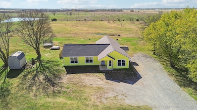
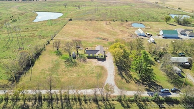
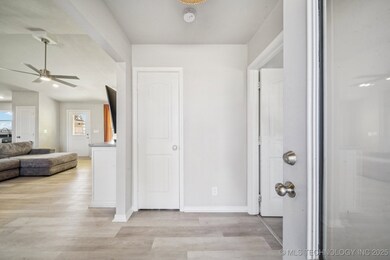
This beautiful, nearly new home offers the perfect blend of country living and modern comfort. Built just two years ago, this spacious 4 bedroom, 2.5 bath home provides plenty of room for family, guests, or a home office setup. Nestled on two peaceful acres at the end of a quiet dead-end road, the setting provides privacy and serenity while still being ideally located between Pryor/Adair and scenic Lake Hudson. Enjoy the best of both worlds with easy access to town amenities, lake recreation and wide-open countryside views. Inside, the home boasts a welcoming open layout, well-appointed kitchen/dining, and comfortable spaces perfect for everyday living and entertainment. Located in one of the area's most desirable school districts of Adair, this property is a wonderful fit for families and anyone looking for room to relax and breathe. Additional features include a storm cellar and storage building. A rare opportunity to enjoy quiet country living with convenience close by, schedule your showing today.
Home Details
Home Type
- Single Family
Year Built
- Built in 2023
Lot Details
- 1.97 Acre Lot
- North Facing Home
- Partially Fenced Property
Home Design
- Slab Foundation
- Wood Frame Construction
- Fiberglass Roof
- HardiePlank Type
- Asphalt
Interior Spaces
- 1,844 Sq Ft Home
- 1-Story Property
- High Ceiling
- Ceiling Fan
- Vinyl Clad Windows
- Insulated Windows
- Insulated Doors
- Vinyl Flooring
- Fire and Smoke Detector
- Washer and Electric Dryer Hookup
Kitchen
- Oven
- Stove
- Range
- Dishwasher
- Granite Countertops
- Disposal
Bedrooms and Bathrooms
- 4 Bedrooms
Eco-Friendly Details
- Energy-Efficient Windows
- Energy-Efficient Doors
Outdoor Features
- Covered Patio or Porch
- Outdoor Storage
- Storm Cellar or Shelter
Schools
- Adair Elementary School
- Adair High School
Utilities
- Zoned Heating and Cooling
- Electric Water Heater
- Septic Tank
- Satellite Dish
Additional Features
- Farm
- Horses Allowed On Property
Community Details
- No Home Owners Association
- Mayes Co Unplatted Subdivision
Listing and Financial Details
- Exclusions: Sellers retain the water softening system in home
Map
Tax History
| Year | Tax Paid | Tax Assessment Tax Assessment Total Assessment is a certain percentage of the fair market value that is determined by local assessors to be the total taxable value of land and additions on the property. | Land | Improvement |
|---|---|---|---|---|
| 2025 | $3,575 | $36,825 | $5,295 | $31,530 |
| 2023 | $3,528 | $5,449 | $5,295 | $154 |
| 2022 | $719 | $8,183 | $3,530 | $4,653 |
| 2021 | $454 | $6,128 | $1,503 | $4,625 |
| 2020 | $643 | $8,170 | $2,908 | $5,262 |
| 2019 | $628 | $7,932 | $2,688 | $5,244 |
| 2018 | $606 | $7,718 | $2,688 | $5,030 |
| 2017 | $677 | $8,762 | $3,518 | $5,244 |
| 2016 | $657 | $8,507 | $2,347 | $6,160 |
| 2015 | $662 | $8,507 | $2,347 | $6,160 |
| 2014 | -- | $2,250 | $2,250 | $0 |
Property History
| Date | Event | Price | List to Sale | Price per Sq Ft |
|---|---|---|---|---|
| 02/06/2026 02/06/26 | Price Changed | $309,000 | -5.9% | $168 / Sq Ft |
| 11/07/2025 11/07/25 | For Sale | $328,500 | -- | $178 / Sq Ft |
Purchase History
| Date | Type | Sale Price | Title Company |
|---|---|---|---|
| Warranty Deed | -- | -- | |
| Warranty Deed | -- | Fidelity National Ttl Ins Co | |
| Warranty Deed | $10,000 | Fidelity National Ttl Ins Co | |
| Warranty Deed | $302,000 | Mayes County Abstract Co | |
| Warranty Deed | $21,000 | None Available | |
| Warranty Deed | $10,000 | None Available | |
| Warranty Deed | $27,000 | -- |
Source: MLS Technology
MLS Number: 2546382
APN: 0000-18-22N-20E-2-003-00
Disclaimer: Certain information contained herein is derived from information provided by parties other than Homes.com. All information provided is deemed reliable, but is not guaranteed to be accurate and should be independently verified.
![]() IDX information is provided exclusively for personal, non-commercial use, and may not be used for any purpose other than to identify prospective properties consumers may be interested in purchasing.
IDX information is provided exclusively for personal, non-commercial use, and may not be used for any purpose other than to identify prospective properties consumers may be interested in purchasing.
Information is deemed reliable but not guaranteed.
- 3901 E 440 Rd
- 5401 N 435 Rd
- 0 N 4390 Rd Unit 2550978
- 0 N 440 Rd Unit 2605157
- 0 N 440 Rd Unit 26-312
- 5931 N 440 Rd
- 1206 Lakeside Dr N
- 5055 E 425 Rd
- 5038 E 422 Rd
- 10 N 434 Rd
- 46 Bluff Rd
- 33 Haleys Dr
- 38 Robin Rd
- 69 Lakeshore Dr
- 768 E Main St
- 4130 N 434
- 0 E 450 Rd Unit 2545216
- 4500 Oklahoma 28
- 581 SE Adair Estates Cir
- 598 SE Adair Estates Cir
- 211 N Grace St
- 209 W Frontier St
- 320 SE 6th St
- 1707 S Elliott St
- 490 S Oak St
- 101 Partridge Dr
- 3660 W 530 Rd
- 907 N Osage Ave
- 224 Silverleaf Ln
- 1400 W Blue Starr Dr
- 1105 W Lawton Rd
- 2001 Fall Ct Unit A
- 2008-2010 Fall Ct Unit 2010
- 773 Hilltop Dr
- 2500 Frederick Rd
- 10134 E King Place
- 24322 S Beulah Cove
- 241 Anchor Rd
- 29180 E 79th St S

Ask me questions while you tour the home.