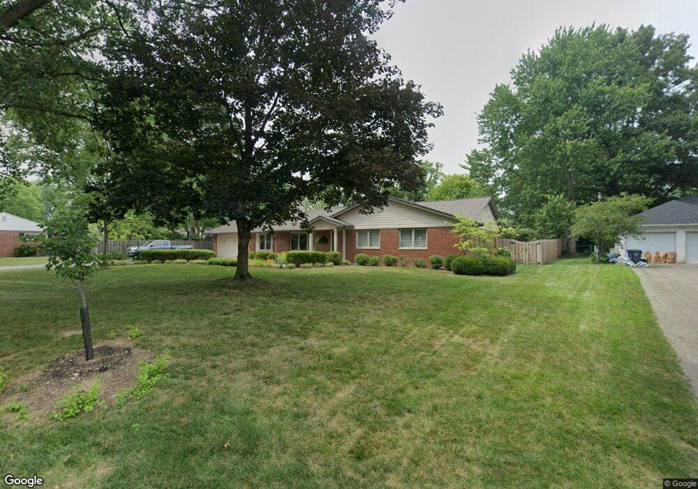
2154 Lytham Rd Columbus, OH 43220
Estimated Value: $579,000 - $822,000
3
Beds
2
Baths
1,922
Sq Ft
$369/Sq Ft
Est. Value
About This Home
This home is located at 2154 Lytham Rd, Columbus, OH 43220 and is currently estimated at $709,216, approximately $368 per square foot. 2154 Lytham Rd is a home located in Franklin County with nearby schools including Windermere Elementary School, Hastings Middle School, and Upper Arlington High School.
Ownership History
Date
Name
Owned For
Owner Type
Purchase Details
Closed on
May 7, 2007
Sold by
Koch Kenneth L and Koch Dorthe E
Bought by
Stratton Leland E and Stratton Adele M
Current Estimated Value
Purchase Details
Closed on
Nov 30, 1999
Sold by
Koch Kenneth L and Koch Dorothe E
Bought by
Koch Kenneth L and Koch Dorthe E
Purchase Details
Closed on
Dec 23, 1985
Bought by
Koch Kenneth L
Create a Home Valuation Report for This Property
The Home Valuation Report is an in-depth analysis detailing your home's value as well as a comparison with similar homes in the area
Home Values in the Area
Average Home Value in this Area
Purchase History
| Date | Buyer | Sale Price | Title Company |
|---|---|---|---|
| Stratton Leland E | $303,000 | Talon Group | |
| Koch Kenneth L | -- | -- | |
| Koch Kenneth L | $117,000 | -- |
Source: Public Records
Tax History
| Year | Tax Paid | Tax Assessment Tax Assessment Total Assessment is a certain percentage of the fair market value that is determined by local assessors to be the total taxable value of land and additions on the property. | Land | Improvement |
|---|---|---|---|---|
| 2025 | $12,249 | $221,380 | $88,940 | $132,440 |
| 2024 | $12,249 | $221,380 | $88,940 | $132,440 |
| 2023 | $12,133 | $221,375 | $88,935 | $132,440 |
| 2022 | $12,023 | $180,810 | $68,600 | $112,210 |
| 2021 | $10,643 | $180,810 | $68,600 | $112,210 |
| 2020 | $10,549 | $180,810 | $68,600 | $112,210 |
| 2019 | $9,861 | $150,960 | $68,600 | $82,360 |
| 2018 | $8,995 | $150,960 | $68,600 | $82,360 |
| 2017 | $9,786 | $150,960 | $68,600 | $82,360 |
| 2016 | $8,192 | $132,650 | $44,380 | $88,270 |
| 2015 | $8,185 | $132,650 | $44,380 | $88,270 |
| 2014 | $8,194 | $132,650 | $44,380 | $88,270 |
| 2013 | $3,886 | $120,610 | $40,355 | $80,255 |
Source: Public Records
Map
Nearby Homes
- 4115 Woodbridge Rd
- 2255 Haviland Rd
- 2411 Lytham Rd
- 3701 Reed Rd
- 2413 Edgevale Rd
- 2458 Edgevale Rd
- 2480 Shrewsbury Rd
- 4545 Benderton Ct
- 1811 Hove Rd
- 2674 Woodstock Rd
- 1594 Lafayette Dr Unit 1594
- 1512 Lafayette Dr Unit B
- 1842 Ridgecliff Rd
- 3161 Avalon Rd
- 2837 Helston Rd
- 2227 Zollinger Rd
- 1744 Ridgecliff Rd Unit 12
- 3830 Riverview Dr
- 3175 Tremont Rd Unit 504
- 3175 Tremont Rd Unit 313
- 2136 Lytham Rd
- 3968 Woodbridge Rd
- 3950 Woodbridge Rd
- 3950 Lytham Ct
- 3950 Lytham Ct
- 3984 Woodbridge Rd
- 2147 Middlesex Rd
- 2151 Lytham Rd
- 2124 Lytham Rd
- 2133 Middlesex Rd
- 2169 Lytham Rd
- 4000 Woodbridge Rd
- 2121 Lytham Rd
- 3921 Bramford Rd
- 3930 Woodbridge Rd
- 2119 Middlesex Rd
- 2110 Lytham Rd
- 3930 Bramford Rd
- 3971 Woodbridge Rd
- 3985 Woodbridge Rd
Your Personal Tour Guide
Ask me questions while you tour the home.