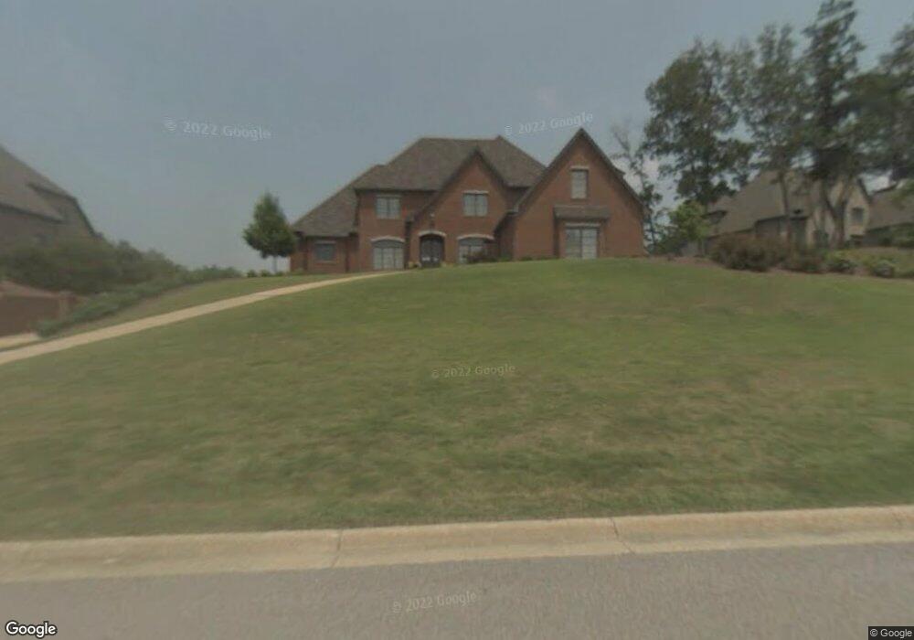
2155 Brook Highland Ridge Birmingham, AL 35242
Estimated Value: $955,417 - $1,149,000
--
Bed
1
Bath
4,744
Sq Ft
$219/Sq Ft
Est. Value
About This Home
This home is located at 2155 Brook Highland Ridge, Birmingham, AL 35242 and is currently estimated at $1,038,604, approximately $218 per square foot. 2155 Brook Highland Ridge is a home located in Shelby County with nearby schools including Inverness Elementary School, Oak Mountain Intermediate School, and Oak Mt. Middle School.
Ownership History
Date
Name
Owned For
Owner Type
Purchase Details
Closed on
Jun 29, 2004
Sold by
Robert S Grant Const Inc
Bought by
Damico Frank and Damico Dee Ann
Current Estimated Value
Purchase Details
Closed on
Mar 7, 2003
Sold by
Eddleman Properties Inc
Bought by
Robert S Grant Const Inc
Home Financials for this Owner
Home Financials are based on the most recent Mortgage that was taken out on this home.
Original Mortgage
$95,000
Outstanding Balance
$40,840
Interest Rate
5.88%
Estimated Equity
$997,764
Create a Home Valuation Report for This Property
The Home Valuation Report is an in-depth analysis detailing your home's value as well as a comparison with similar homes in the area
Home Values in the Area
Average Home Value in this Area
Purchase History
| Date | Buyer | Sale Price | Title Company |
|---|---|---|---|
| Damico Frank | $627,740 | -- | |
| Robert S Grant Const Inc | $95,000 | -- |
Source: Public Records
Mortgage History
| Date | Status | Borrower | Loan Amount |
|---|---|---|---|
| Open | Robert S Grant Const Inc | $95,000 |
Source: Public Records
Tax History Compared to Growth
Tax History
| Year | Tax Paid | Tax Assessment Tax Assessment Total Assessment is a certain percentage of the fair market value that is determined by local assessors to be the total taxable value of land and additions on the property. | Land | Improvement |
|---|---|---|---|---|
| 2024 | $4,100 | $93,180 | $0 | $0 |
| 2023 | $3,978 | $91,340 | $0 | $0 |
| 2022 | $3,773 | $86,680 | $0 | $0 |
| 2021 | $3,441 | $79,140 | $0 | $0 |
| 2020 | $3,213 | $73,960 | $0 | $0 |
| 2019 | $3,038 | $69,980 | $0 | $0 |
| 2017 | $2,865 | $66,040 | $0 | $0 |
| 2015 | $2,730 | $62,980 | $0 | $0 |
| 2014 | $2,685 | $61,960 | $0 | $0 |
Source: Public Records
Map
Nearby Homes
- 2096 Brook Highland Ridge
- 1010 Warrington Cir
- 2080 Brook Highland Ridge
- 2076 Brook Highland Ridge
- 4227 Ashington Dr
- 1645 Wingfield Dr
- 1616 Wingfield Trace
- 4401 Sicard Hollow Rd
- 3100 Somerset Trace
- 3071 Somerset Trace
- 225 Courtside Dr
- 3212 Brook Highland Trace
- 3213 Brook Highland Trace
- 243 Courtside Dr Unit 45
- 4520 Amberley Dr
- 121 Palmer Cove
- 2552 Magnolia Place
- 4601 Amberley Dr
- 4610 Cotswold Ln
- 4632 Cotswold Ln
- 2151 Brook Highland Ridge
- 2159 Brook Highland Ridge
- 2154 Brook Highland Ridge
- 2158 Brook Highland Ridge
- 2163 Brook Highland Ridge
- 2147 Brook Highland Ridge
- 2162 Brook Highland Ridge
- 2144 Brook Highland Ridge
- 2141 Brook Highland Ridge
- 2167 Brook Highland Ridge
- 1067 Williams Trace Unit Lot - 2512
- 2137 Brook Highland Ridge
- 2136 Brook Highland Ridge
- 1070 Williams Trace
- 1059 Williams Trace
- 1047 Williams Trace
- 2133 Brook Highland Ridge
- 2134 Brook Highland Ridge
- 1053 Williams Trace
- 1045 Williams Trace