
Estimated payment $6,609/month
Total Views
1,373
6
Beds
5
Baths
4,230
Sq Ft
$273
Price per Sq Ft
Highlights
- Second Kitchen
- RV or Boat Parking
- 0.51 Acre Lot
- Dry Creek Elementary School Rated A-
- Waterfall on Lot
- Vaulted Ceiling
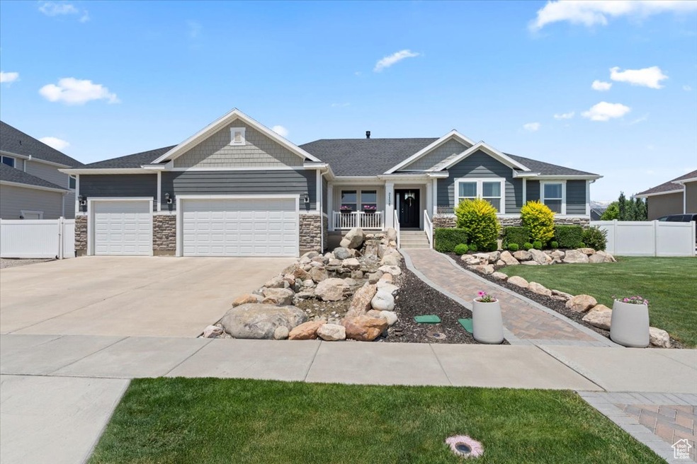
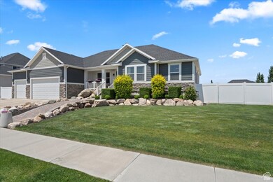
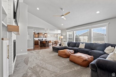
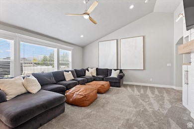
About This Home
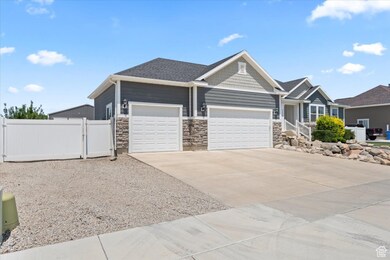
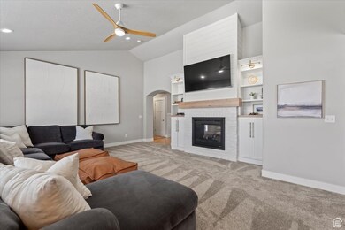
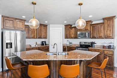
HUGE 40' x 60' BONUS SHOP WITH 2 OFFICES CAN FIT 4 CARS! Get the most bang for your buck with this house! You're instantly greeted by the tranquil sound of the waterfall that is automatically filled and can be turned on and off by a switch inside. Upstairs, you'll find three generous bedrooms, two and a half bathrooms, a laundry room, and an office. Downstairs, the fully finished basement offers a complete apartment with three bedrooms, two bathrooms, a modern kitchen, its own laundry space, and a private entrance! Perfect for guests, rental income, or multigenerational living. Things that set this home apart from the rest - 2 water heaters that deliver instantaneous hot water, new roof, new carpet throughout, a water filtration and UV light system. The dreamy backyard has a sidewalk that runs along the perimeter of the yard, the gas line run for the built in fire pit and pizza oven area, foundations for a future deck and we can't miss the huge 40' x 60', 2400 sq ft shop! The shop has an office on the main and a 600 sq ft shop upstairs. It also has 2 bathrooms, heating and air, footings for a car lift, dust collection piping in the floor, outlets in the floor and 200 amp electricity. This home provides convenient RV storage behind the fence on a cement pad with an RV clean out installed. Listing agent related to seller.
Listing Agent
Christee Nabor
Equity Real Estate (Buckley) License #7625480 Listed on: 06/05/2025
Home Details
Home Type
- Single Family
Est. Annual Taxes
- $3,130
Year Built
- Built in 2013
Lot Details
- 0.51 Acre Lot
- Property is Fully Fenced
- Landscaped
- Property is zoned Single-Family
Parking
- 7 Car Attached Garage
- RV or Boat Parking
Home Design
- Rambler Architecture
- Stone Siding
- Stucco
Interior Spaces
- 4,230 Sq Ft Home
- 2-Story Property
- Vaulted Ceiling
- Ceiling Fan
- 2 Fireplaces
- Self Contained Fireplace Unit Or Insert
- Double Pane Windows
- Blinds
- Sliding Doors
- Smart Doorbell
- Great Room
- Den
- Smart Thermostat
- Electric Dryer Hookup
Kitchen
- Second Kitchen
- Free-Standing Range
- Microwave
- Granite Countertops
- Disposal
- Instant Hot Water
Flooring
- Carpet
- Laminate
- Tile
Bedrooms and Bathrooms
- 6 Bedrooms | 3 Main Level Bedrooms
- Primary Bedroom on Main
- Walk-In Closet
- In-Law or Guest Suite
Basement
- Walk-Out Basement
- Basement Fills Entire Space Under The House
- Exterior Basement Entry
- Apartment Living Space in Basement
Eco-Friendly Details
- Reclaimed Water Irrigation System
Outdoor Features
- Waterfall on Lot
- Separate Outdoor Workshop
- Outbuilding
- Play Equipment
Schools
- Dry Creek Elementary School
- Willowcreek Middle School
- Lehi High School
Utilities
- Central Heating and Cooling System
- Natural Gas Connected
Community Details
- No Home Owners Association
- Snow's Springs Subdivision
Listing and Financial Details
- Exclusions: Dryer, Freezer, Gas Grill/BBQ, Washer
- Assessor Parcel Number 66-371-0013
Map
Create a Home Valuation Report for This Property
The Home Valuation Report is an in-depth analysis detailing your home's value as well as a comparison with similar homes in the area
Home Values in the Area
Average Home Value in this Area
Tax History
| Year | Tax Paid | Tax Assessment Tax Assessment Total Assessment is a certain percentage of the fair market value that is determined by local assessors to be the total taxable value of land and additions on the property. | Land | Improvement |
|---|---|---|---|---|
| 2024 | $3,131 | $366,410 | $0 | $0 |
| 2023 | $2,915 | $370,425 | $0 | $0 |
| 2022 | $3,126 | $385,110 | $0 | $0 |
| 2021 | $2,790 | $519,500 | $168,400 | $351,100 |
| 2020 | $2,629 | $484,000 | $155,900 | $328,100 |
| 2019 | $2,311 | $442,300 | $155,900 | $286,400 |
| 2018 | $2,300 | $416,100 | $143,300 | $272,800 |
| 2017 | $2,335 | $224,565 | $0 | $0 |
| 2016 | $2,365 | $211,090 | $0 | $0 |
| 2015 | $2,289 | $193,875 | $0 | $0 |
| 2014 | $2,187 | $184,195 | $0 | $0 |
Source: Public Records
Property History
| Date | Event | Price | Change | Sq Ft Price |
|---|---|---|---|---|
| 06/19/2025 06/19/25 | Pending | -- | -- | -- |
| 06/05/2025 06/05/25 | For Sale | $1,155,000 | -- | $273 / Sq Ft |
Source: UtahRealEstate.com
Purchase History
| Date | Type | Sale Price | Title Company |
|---|---|---|---|
| Warranty Deed | -- | Affiliated First Title Co |
Source: Public Records
Mortgage History
| Date | Status | Loan Amount | Loan Type |
|---|---|---|---|
| Open | $450,000 | Credit Line Revolving | |
| Closed | $150,000 | Credit Line Revolving | |
| Closed | $318,000 | New Conventional | |
| Closed | $346,737 | New Conventional | |
| Closed | $341,905 | New Conventional |
Source: Public Records
Similar Homes in Lehi, UT
Source: UtahRealEstate.com
MLS Number: 2089934
APN: 66-371-0013
Disclaimer: Certain information contained herein is derived from information provided by parties other than Homes.com. All information provided is deemed reliable, but is not guaranteed to be accurate and should be independently verified.
![]() IDX information is provided exclusively for consumers’ personal, non-commercial use, that it may not be used for any purpose other than to identify prospective properties consumers may be interested in purchasing, and that the data is deemed reliable but is not guaranteed accurate by the MLS. Licensor is only providing the MLS Content and not other sources of data provided in the Product.
IDX information is provided exclusively for consumers’ personal, non-commercial use, that it may not be used for any purpose other than to identify prospective properties consumers may be interested in purchasing, and that the data is deemed reliable but is not guaranteed accurate by the MLS. Licensor is only providing the MLS Content and not other sources of data provided in the Product.
Based on information from the Wasatch Front Regional Multiple Listing Service, Inc.. All data, including all measurements and calculations of area, is obtained from various sources and has not been, and will not be, verified by broker or the MLS. All information should be independently reviewed and verified for accuracy. Properties may or may not be listed by the office/agent presenting the information.
Nearby Homes
- 2156 W Thomas St Unit 13
- 2201 W 1300 S
- 1362 1960 W Unit 3
- 1154 E Fathom Ln Unit 87
- 1147 E Fathom Ln
- 1852 W 1650 S
- 473 N Northshore Dr
- 1873 W 1650 S
- 458 N Trident Dr
- 1158 E Bearing Dr
- 388 N Regatta Ln
- 1111 E Waterway Ln
- 1128 E Bearing Dr
- 1073 E Dory Boat Rd
- 1027 Reef Dr
- 1967 E 145 N
- 278 N Portside Ln
- 278 Portside Ln
- 1099 Quarter Deck Way
- 944 Jack Dr