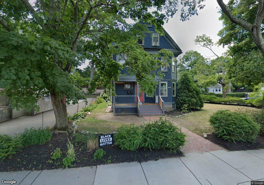
216 Cabot St Newtonville, MA 02460
Newtonville NeighborhoodEstimated Value: $621,113 - $830,000
2
Beds
2
Baths
1,057
Sq Ft
$710/Sq Ft
Est. Value
About This Home
This home is located at 216 Cabot St, Newtonville, MA 02460 and is currently estimated at $750,028, approximately $709 per square foot. 216 Cabot St is a home located in Middlesex County with nearby schools including Cabot Elementary School, F.A. Day Middle School, and Newton North High School.
Ownership History
Date
Name
Owned For
Owner Type
Purchase Details
Closed on
Sep 17, 2025
Sold by
Meese Lauren
Bought by
Lauren A Meese Lt and Meese
Current Estimated Value
Purchase Details
Closed on
Jan 31, 2004
Sold by
Srb Assoc Llc
Bought by
Marino Regina M
Purchase Details
Closed on
Jul 1, 2003
Sold by
Srb Assoc Llc
Bought by
Weinstein Linda C and Weinstein Linda
Home Financials for this Owner
Home Financials are based on the most recent Mortgage that was taken out on this home.
Original Mortgage
$322,700
Interest Rate
5.53%
Mortgage Type
Purchase Money Mortgage
Purchase Details
Closed on
Mar 29, 2002
Sold by
Fecteau Ralph D Est and Mcavoy
Bought by
Srb Assocs
Home Financials for this Owner
Home Financials are based on the most recent Mortgage that was taken out on this home.
Original Mortgage
$280,000
Interest Rate
6.88%
Mortgage Type
Purchase Money Mortgage
Create a Home Valuation Report for This Property
The Home Valuation Report is an in-depth analysis detailing your home's value as well as a comparison with similar homes in the area
Home Values in the Area
Average Home Value in this Area
Purchase History
| Date | Buyer | Sale Price | Title Company |
|---|---|---|---|
| Lauren A Meese Lt | -- | -- | |
| Marino Regina M | $342,500 | -- | |
| Marino Regina M | $342,500 | -- | |
| Weinstein Linda C | $450,000 | -- | |
| Weinstein Linda C | $450,000 | -- | |
| Srb Assocs | $400,000 | -- | |
| Srb Assocs | $400,000 | -- |
Source: Public Records
Mortgage History
| Date | Status | Borrower | Loan Amount |
|---|---|---|---|
| Previous Owner | Weinstein Linda C | $322,700 | |
| Previous Owner | Srb Assocs | $280,000 |
Source: Public Records
Tax History Compared to Growth
Tax History
| Year | Tax Paid | Tax Assessment Tax Assessment Total Assessment is a certain percentage of the fair market value that is determined by local assessors to be the total taxable value of land and additions on the property. | Land | Improvement |
|---|---|---|---|---|
| 2025 | $5,144 | $524,900 | $0 | $524,900 |
| 2024 | $4,974 | $509,600 | $0 | $509,600 |
| 2023 | $4,861 | $477,500 | $0 | $477,500 |
| 2022 | $4,784 | $454,800 | $0 | $454,800 |
| 2021 | $4,617 | $429,100 | $0 | $429,100 |
| 2020 | $4,480 | $429,100 | $0 | $429,100 |
| 2019 | $5,277 | $416,600 | $0 | $416,600 |
| 2018 | $4,366 | $403,500 | $0 | $403,500 |
| 2017 | $4,486 | $380,700 | $0 | $380,700 |
| 2016 | $4,049 | $355,800 | $0 | $355,800 |
| 2015 | $3,935 | $338,900 | $0 | $338,900 |
Source: Public Records
Map
Nearby Homes
- 44 Blake St Unit 2
- 127-129 Withington Rd Unit 1
- 110 Harvard St Unit A
- 10 Washington Park
- 10 Washington Park Unit 2
- 10 Washington Park Unit 1
- 300 Cabot St
- 48 Harvard St Unit 1
- 230 Bellevue St Unit 1
- 22 Walnut Place Unit 1
- 3 Cedar St
- 77 Court St Unit 205
- 686 Centre St
- 324 Adams St Unit 2
- 14 Summit St
- 35 George St Unit 35
- 37 George St Unit 37
- 642 Centre St
- 22-24 Emerald St
- 73 Elmore St
- 218 Cabot St
- 216 Cabot St Unit 1
- 214 Cabot St
- 212 Cabot St
- 14-16 Blake St Unit first floor
- 14 Blake St Unit 16
- 206-208 Cabot St
- 206 Cabot St Unit 2
- 206 Cabot St Unit 208
- 226 Cabot St Unit 228
- 9 Blake St Unit 11
- 22 Blake St
- 20 Blake St
- 15 Blake St
- 5 Westchester Rd Unit 5
- 57 Westchester Rd
- 5 Westchester Rd Unit 1
- 5 Westcester Unit 2
- 19 Blake St
- 230 Cabot St Unit 1