
Seller's Agent in 2025
Ryan Ford
Triangle Real Estate Journal
(919) 724-7010
1 in this area
61 Total Sales

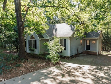
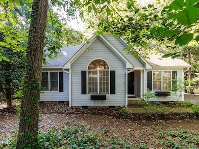
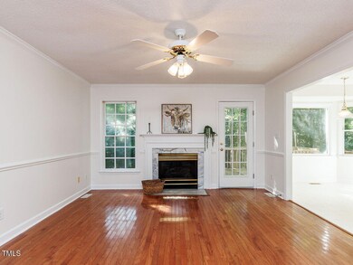
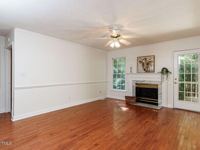
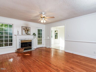
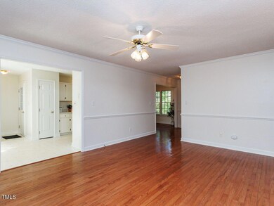
Located in Creekstone, this 3-bedroom, 2-bath home offers comfortable one-level living on a private 0.75-acre cul-de-sac lot. Fresh paint, new carpet, and hardwood floors create a move-in ready feel, while a gas fireplace, separate dining room, and bay-window breakfast nook add charm. The kitchen, with window views and included refrigerator, offers ample storage and potential for your personal touch. A vaulted ceiling enhances the front bedroom, while the primary suite overlooks the backyard with mature trees, garden space, and two fig trees. A rear deck and detached shed/workshop extend the living outdoors. With no city taxes, no HOA, & a great price, this home delivers both value & flexibility—plus walkable streets & an easy 30-minute drive to downtown Raleigh.
Last Agent to Sell the Property
Triangle Real Estate Journal License #250895 Listed on: 09/12/2025
| Date | Type | Sale Price | Title Company |
|---|---|---|---|
| Warranty Deed | $285,000 | None Listed On Document | |
| Warranty Deed | $175,000 | None Available | |
| Deed | -- | -- |
| Date | Status | Loan Amount | Loan Type |
|---|---|---|---|
| Open | $15,000 | No Value Available | |
| Open | $278,438 | FHA | |
| Previous Owner | $171,830 | FHA |
| Date | Event | Price | List to Sale | Price per Sq Ft |
|---|---|---|---|---|
| 11/24/2025 11/24/25 | Sold | $285,000 | 0.0% | $216 / Sq Ft |
| 10/18/2025 10/18/25 | Pending | -- | -- | -- |
| 10/09/2025 10/09/25 | Price Changed | $285,000 | -0.7% | $216 / Sq Ft |
| 09/12/2025 09/12/25 | For Sale | $287,000 | -- | $217 / Sq Ft |
| Year | Tax Paid | Tax Assessment Tax Assessment Total Assessment is a certain percentage of the fair market value that is determined by local assessors to be the total taxable value of land and additions on the property. | Land | Improvement |
|---|---|---|---|---|
| 2025 | $1,875 | $295,280 | $85,000 | $210,280 |
| 2024 | $1,313 | $162,150 | $44,000 | $118,150 |
| 2023 | $1,273 | $162,150 | $44,000 | $118,150 |
| 2022 | $1,313 | $162,150 | $44,000 | $118,150 |
| 2021 | $1,313 | $162,150 | $44,000 | $118,150 |
| 2020 | $1,340 | $159,570 | $44,000 | $115,570 |
| 2019 | $1,308 | $159,570 | $44,000 | $115,570 |
| 2018 | $0 | $109,160 | $27,500 | $81,660 |
| 2017 | $917 | $109,160 | $27,500 | $81,660 |
| 2016 | $917 | $109,160 | $27,500 | $81,660 |
| 2014 | -- | $109,160 | $27,500 | $81,660 |
Seller's Agent in 2025
Ryan Ford
Triangle Real Estate Journal
(919) 724-7010
1 in this area
61 Total Sales
I
Buyer's Agent in 2025
Ian Hutchison
Costello Real Estate & Investm
(919) 527-5002
1 in this area
6 Total Sales
Source: Doorify MLS
MLS Number: 10121417
APN: 13E04024R
Disclaimer: Certain information contained herein is derived from information provided by parties other than Homes.com. All information provided is deemed reliable, but is not guaranteed to be accurate and should be independently verified.
![]() Some IDX listings have been excluded from this IDX display. Brokers make an effort to deliver accurate information, but buyers should independently verify any information on which they will rely in a transaction. The listing broker shall not be responsible for any typographical errors, misinformation, or misprints, and they shall be held totally harmless from any damages arising from reliance upon this data. This data is provided exclusively for consumers’ personal, non-commercial use. Listings marked with an icon are provided courtesy of the Doorify MLS, Inc. of North Carolina, Internet Data Exchange Database. Closed (sold) listings may have been listed and/or sold by a real estate firm other than the firm(s) featured on this website. Closed data is not available until the sale of the property is recorded in the MLS. Home sale data is not an appraisal, CMA, competitive or comparative market analysis, or home valuation of any property. Copyright 2026 Doorify MLS, Inc. of North Carolina. All rights reserved.
Some IDX listings have been excluded from this IDX display. Brokers make an effort to deliver accurate information, but buyers should independently verify any information on which they will rely in a transaction. The listing broker shall not be responsible for any typographical errors, misinformation, or misprints, and they shall be held totally harmless from any damages arising from reliance upon this data. This data is provided exclusively for consumers’ personal, non-commercial use. Listings marked with an icon are provided courtesy of the Doorify MLS, Inc. of North Carolina, Internet Data Exchange Database. Closed (sold) listings may have been listed and/or sold by a real estate firm other than the firm(s) featured on this website. Closed data is not available until the sale of the property is recorded in the MLS. Home sale data is not an appraisal, CMA, competitive or comparative market analysis, or home valuation of any property. Copyright 2026 Doorify MLS, Inc. of North Carolina. All rights reserved.
Ask me questions while you tour the home.