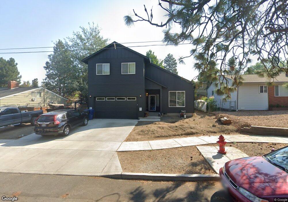
216 NE 5th St Bend, OR 97701
Larkspur NeighborhoodEstimated Value: $680,000 - $788,000
2
Beds
1
Bath
912
Sq Ft
$822/Sq Ft
Est. Value
About This Home
This home is located at 216 NE 5th St, Bend, OR 97701 and is currently estimated at $749,302, approximately $821 per square foot. 216 NE 5th St is a home located in Deschutes County with nearby schools including Juniper Elementary School, Pilot Butte Middle School, and Bend Senior High School.
Ownership History
Date
Name
Owned For
Owner Type
Purchase Details
Closed on
Jan 4, 2024
Sold by
Sieverson Penny Jo
Bought by
Will Cory V
Current Estimated Value
Home Financials for this Owner
Home Financials are based on the most recent Mortgage that was taken out on this home.
Original Mortgage
$560,000
Outstanding Balance
$549,832
Interest Rate
7.29%
Mortgage Type
New Conventional
Estimated Equity
$199,470
Purchase Details
Closed on
Jul 15, 2020
Sold by
Nelson Deborah Diane
Bought by
Will Cory Vernon
Home Financials for this Owner
Home Financials are based on the most recent Mortgage that was taken out on this home.
Original Mortgage
$125,000
Interest Rate
3.1%
Mortgage Type
New Conventional
Purchase Details
Closed on
May 29, 2009
Sold by
Will Vern
Bought by
Will Vernon and Nelson Deborah Diane
Create a Home Valuation Report for This Property
The Home Valuation Report is an in-depth analysis detailing your home's value as well as a comparison with similar homes in the area
Home Values in the Area
Average Home Value in this Area
Purchase History
| Date | Buyer | Sale Price | Title Company |
|---|---|---|---|
| Will Cory V | -- | Deschutes Title | |
| Will Cory Vernon | $125,000 | None Available | |
| Will Vernon | $42,000 | None Available |
Source: Public Records
Mortgage History
| Date | Status | Borrower | Loan Amount |
|---|---|---|---|
| Open | Will Cory V | $560,000 | |
| Previous Owner | Will Cory Vernon | $125,000 |
Source: Public Records
Tax History
| Year | Tax Paid | Tax Assessment Tax Assessment Total Assessment is a certain percentage of the fair market value that is determined by local assessors to be the total taxable value of land and additions on the property. | Land | Improvement |
|---|---|---|---|---|
| 2025 | $4,729 | $279,870 | -- | -- |
| 2024 | $4,550 | $271,720 | -- | -- |
| 2023 | $4,217 | $263,810 | $0 | $0 |
| 2022 | $965 | $60,980 | $0 | $0 |
| 2021 | $966 | $59,210 | $0 | $0 |
| 2020 | $917 | $59,210 | $0 | $0 |
| 2019 | $1,786 | $115,200 | $0 | $0 |
| 2018 | $1,736 | $111,850 | $0 | $0 |
| 2017 | $1,685 | $108,600 | $0 | $0 |
| 2016 | $1,607 | $105,440 | $0 | $0 |
| 2015 | $1,562 | $102,370 | $0 | $0 |
| 2014 | $1,517 | $99,390 | $0 | $0 |
Source: Public Records
Map
Nearby Homes
- 775 NE Franklin Ave
- 438 NE 9th St
- 530 SE Centennial St Unit 524,526,528,530
- 513 NE Irving Ave
- 429 NE Irving Ave
- 15 NW Franklin Ave
- 114 NW Delaware Ave
- 508 SE 4th St
- 924 NE 9th St
- 649 NE Kearney Ave
- 530 SE 3rd St
- 1363 NE Bear Creek Rd
- 111 NW Hawthorne Ave Unit 1
- 120 NW Sisemore St
- 566 NE Lafayette Ave Unit 1
- 1119 NE 9th St
- 558 NE Lafayette Ave
- 314 NW Georgia Ave
- 1154 NE 9th St
- 623 SE Roosevelt Ave
- 230 NE 5th St
- 204 NE 5th St Unit ID1247402P
- 204 NE 5th St
- 526 NE Burnside Ave
- 532 NE Burnside Ave
- 242 NE 5th St
- 478 NE Burnside Ave
- 529 NE Clay Ave
- 505 NE Burnside Ave
- 471 NE Clay Ave
- 521 NE Burnside Ave Unit 1
- 521 NE Burnside Ave
- 534 NE Burnside Ave
- 537 NE Burnside Ave
- 549 NE Clay Ave
- 455 NE Clay Ave
- 454 NE Burnside Ave
- 150 NE 5th St
- 450 NE Burnside Ave
- 312 NE 5th St
Your Personal Tour Guide
Ask me questions while you tour the home.