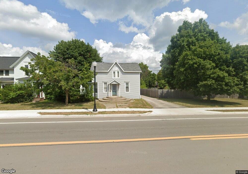
217 E Houghton Ave West Branch, MI 48661
Estimated Value: $155,000 - $229,000
4
Beds
2
Baths
2,000
Sq Ft
$94/Sq Ft
Est. Value
About This Home
This home is located at 217 E Houghton Ave, West Branch, MI 48661 and is currently estimated at $188,907, approximately $94 per square foot. 217 E Houghton Ave is a home located in Ogemaw County with nearby schools including Surline Elementary School, Surline Middle School, and Ogemaw Heights High School.
Ownership History
Date
Name
Owned For
Owner Type
Purchase Details
Closed on
Jan 24, 2012
Sold by
Dematio Mark and Dematio Rosemary
Bought by
Dematio Michael
Current Estimated Value
Purchase Details
Closed on
Oct 11, 2011
Sold by
Lps Asset Management Solutions
Bought by
Dematio Mark and Dematio Rosemary
Purchase Details
Closed on
Jan 25, 2005
Sold by
Bray-Collins Jan Elizabeth and Collins Jay Daniel
Bought by
Cross Larry Dean
Purchase Details
Closed on
Apr 1, 2002
Bought by
Cross Ii Larry Dean
Create a Home Valuation Report for This Property
The Home Valuation Report is an in-depth analysis detailing your home's value as well as a comparison with similar homes in the area
Home Values in the Area
Average Home Value in this Area
Purchase History
| Date | Buyer | Sale Price | Title Company |
|---|---|---|---|
| Dematio Michael | $45,000 | -- | |
| Dematio Mark | $43,000 | -- | |
| Cross Larry Dean | $116,000 | -- | |
| Cross Ii Larry Dean | $116,000 | -- |
Source: Public Records
Tax History Compared to Growth
Tax History
| Year | Tax Paid | Tax Assessment Tax Assessment Total Assessment is a certain percentage of the fair market value that is determined by local assessors to be the total taxable value of land and additions on the property. | Land | Improvement |
|---|---|---|---|---|
| 2025 | $2,450 | $59,700 | $0 | $0 |
| 2024 | $17 | $57,800 | $0 | $0 |
| 2023 | $1,550 | $50,700 | $0 | $0 |
| 2022 | $2,164 | $41,400 | $0 | $0 |
| 2021 | $2,055 | $38,800 | $0 | $0 |
| 2020 | $2,066 | $36,300 | $0 | $0 |
| 2019 | $2,074 | $34,800 | $0 | $0 |
| 2018 | $1,931 | $33,700 | $0 | $0 |
| 2017 | $1,851 | $35,100 | $0 | $0 |
| 2016 | $1,792 | $34,900 | $0 | $0 |
| 2015 | $1,719 | $32,750 | $0 | $0 |
| 2014 | $340 | $34,000 | $0 | $0 |
Source: Public Records
Map
Nearby Homes
- 227 N 1st St
- 240 N Burgess St
- 0 S First St Unit 1932836
- 315 S 4th St
- 195 Fremont St
- 361 Irons Park Dr
- 324 N 4th St
- 272 Windemere Place Unit 14A
- 268 Windemere Place Unit 14B
- 0 Fairview Rd Unit 1939430
- Parcel 1 M-76
- Parcel 2 M-76
- 206 Highland St
- 2301 Birchcrest Dr
- 2190 Fox Run
- 2249 Fox Run
- 2249 W State Rd
- 2371 Pilatus Ct
- 0 W M-76 Unit 1925090
- 0 W M-76 Unit 1905107
- 203 E Houghton Ave
- 227 E Houghton Ave
- 211 E Houghton Ave
- 203 E Houghton Ave
- 222 E Houghton Ave
- 212 E Houghton Ave
- 208 E Houghton Ave
- 202 E Houghton Ave
- 124 E Houghton Ave
- 102 E Houghton Ave Unit . A
- 102 E Houghton Ave Unit B
- 146 S Livingston St
- 136 S Livingston St
- 122 S Livingston St
- 118 S Livingston St
- 112 S Livingston St
- 131 S Livingston St
- 127 S Livingston St
- 123 S Livingston St
- 119 S Livingston St