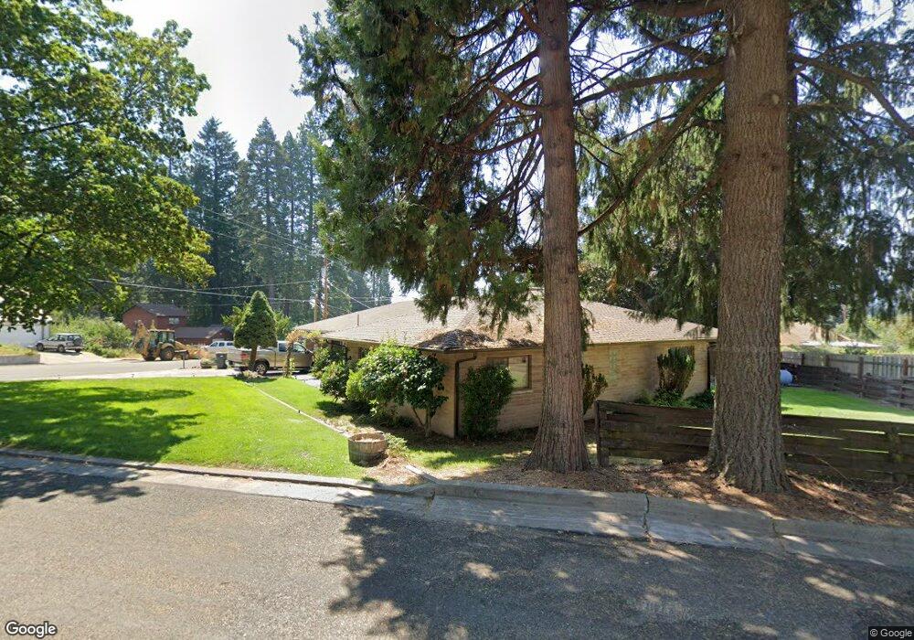
217 Eugene Ave Mount Shasta, CA 96067
Estimated Value: $416,000 - $480,000
3
Beds
2
Baths
1,681
Sq Ft
$260/Sq Ft
Est. Value
About This Home
This home is located at 217 Eugene Ave, Mount Shasta, CA 96067 and is currently estimated at $437,457, approximately $260 per square foot. 217 Eugene Ave is a home located in Siskiyou County with nearby schools including Mt. Shasta Elementary School, Mt. Shasta High School, and Golden Eagle Charter School.
Ownership History
Date
Name
Owned For
Owner Type
Purchase Details
Closed on
Jun 28, 2006
Sold by
Rodriguez Michael G and Rodriguez Barbara K
Bought by
Rodriguez Michael G and Rodriguez Barbara K
Current Estimated Value
Home Financials for this Owner
Home Financials are based on the most recent Mortgage that was taken out on this home.
Original Mortgage
$307,200
Outstanding Balance
$191,947
Interest Rate
7.62%
Mortgage Type
New Conventional
Estimated Equity
$245,510
Purchase Details
Closed on
Dec 15, 2004
Sold by
Rodriguez Michael G and Rodriguez Barbara K
Bought by
Rodriguez Michael G and Rodriguez Barbara K
Purchase Details
Closed on
Jul 20, 2001
Sold by
Pelletier Jeanette
Bought by
Rodriguez Michael G and Rodriguez Barbara K
Home Financials for this Owner
Home Financials are based on the most recent Mortgage that was taken out on this home.
Original Mortgage
$146,500
Interest Rate
7.15%
Create a Home Valuation Report for This Property
The Home Valuation Report is an in-depth analysis detailing your home's value as well as a comparison with similar homes in the area
Home Values in the Area
Average Home Value in this Area
Purchase History
| Date | Buyer | Sale Price | Title Company |
|---|---|---|---|
| Rodriguez Michael G | -- | Mt Shasta Title & Escrow Co | |
| Rodriguez Michael G | -- | Mt Shasta Title & Escrow Co | |
| Rodriguez Michael G | -- | -- | |
| Rodriguez Michael G | $201,500 | -- |
Source: Public Records
Mortgage History
| Date | Status | Borrower | Loan Amount |
|---|---|---|---|
| Open | Rodriguez Michael G | $307,200 | |
| Closed | Rodriguez Michael G | $146,500 |
Source: Public Records
Tax History
| Year | Tax Paid | Tax Assessment Tax Assessment Total Assessment is a certain percentage of the fair market value that is determined by local assessors to be the total taxable value of land and additions on the property. | Land | Improvement |
|---|---|---|---|---|
| 2025 | $3,100 | $297,652 | $105,614 | $192,038 |
| 2023 | $3,100 | $286,096 | $101,514 | $184,582 |
| 2022 | $2,981 | $280,487 | $99,524 | $180,963 |
| 2021 | $2,930 | $274,988 | $97,573 | $177,415 |
| 2020 | $2,929 | $272,169 | $96,573 | $175,596 |
| 2019 | $2,874 | $266,833 | $94,680 | $172,153 |
| 2018 | $2,818 | $261,602 | $92,824 | $168,778 |
| 2017 | $2,790 | $256,473 | $91,004 | $165,469 |
| 2016 | $2,735 | $251,445 | $89,220 | $162,225 |
| 2015 | $2,496 | $229,000 | $66,000 | $163,000 |
| 2014 | $2,270 | $208,000 | $60,000 | $148,000 |
Source: Public Records
Map
Nearby Homes
- 102 S A St
- 0 Berry St
- 415 Old McCloud Rd
- 509 Mccloud Ave
- 00 S Mount Shasta Blvd
- Lot 16 Quail Hill Dr
- 706 Glen Mar Dr
- 0 Lot 8 Gateway Park
- 0 Alma St Apn #057-203-040
- 307 N Adams Dr
- 0 S Mount Shasta Blvd
- lot 7 Ream Ave
- 1007 Mccloud Ave
- 1227 Eddy Dr
- 1517 Eddy Dr
- 300 E Jessie St
- 322 E Jessie St
- Lot 1 S Old Stage Rd
- 1539 Eddy Dr
- 709 Cedar St
Your Personal Tour Guide
Ask me questions while you tour the home.