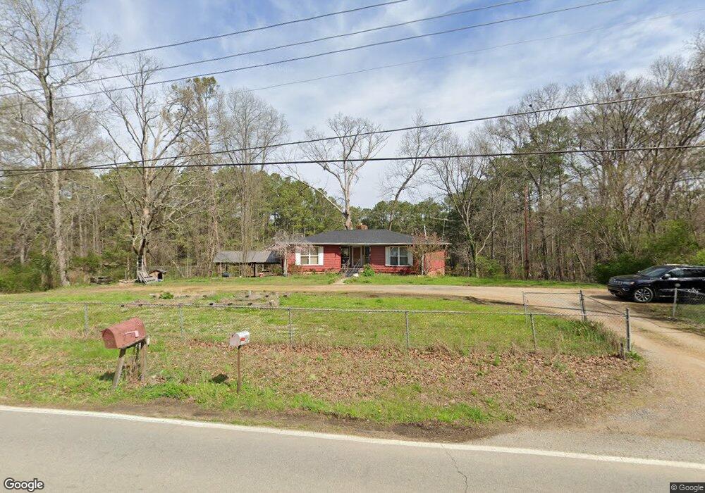
217 Lake Howard Rd La Fayette, GA 30728
Estimated Value: $259,778 - $357,000
--
Bed
2
Baths
1,582
Sq Ft
$196/Sq Ft
Est. Value
About This Home
This home is located at 217 Lake Howard Rd, La Fayette, GA 30728 and is currently estimated at $309,445, approximately $195 per square foot. 217 Lake Howard Rd is a home located in Walker County with nearby schools including Rock Spring Elementary School, Lafayette High School, and Lafayette Christian Academy.
Ownership History
Date
Name
Owned For
Owner Type
Purchase Details
Closed on
May 10, 2024
Sold by
Ferris Brandy Laura
Bought by
Shelton Phillip Wayne and Shelton Mary Jane Strickland Trust
Current Estimated Value
Purchase Details
Closed on
Sep 25, 2015
Sold by
Shelton Phillip W
Bought by
Shelton Phillip Wayne and Strickland Mary Jane
Purchase Details
Closed on
Jun 21, 1974
Bought by
Shelton Phillip W and Shelton Jane
Create a Home Valuation Report for This Property
The Home Valuation Report is an in-depth analysis detailing your home's value as well as a comparison with similar homes in the area
Home Values in the Area
Average Home Value in this Area
Purchase History
| Date | Buyer | Sale Price | Title Company |
|---|---|---|---|
| Shelton Phillip Wayne | -- | -- | |
| Shelton Phillip Wayne | $153,087 | -- | |
| Shelton Phillip W | -- | -- |
Source: Public Records
Tax History Compared to Growth
Tax History
| Year | Tax Paid | Tax Assessment Tax Assessment Total Assessment is a certain percentage of the fair market value that is determined by local assessors to be the total taxable value of land and additions on the property. | Land | Improvement |
|---|---|---|---|---|
| 2024 | $1,399 | $96,870 | $12,210 | $84,660 |
| 2023 | $1,345 | $92,412 | $12,210 | $80,202 |
| 2022 | $1,198 | $82,074 | $12,210 | $69,864 |
| 2021 | $1,054 | $70,686 | $12,210 | $58,476 |
| 2020 | $919 | $63,097 | $12,210 | $50,887 |
| 2019 | $951 | $63,097 | $12,210 | $50,887 |
| 2018 | $1,670 | $63,097 | $12,210 | $50,887 |
| 2017 | $788 | $62,857 | $11,970 | $50,887 |
| 2016 | $788 | $62,857 | $11,970 | $50,887 |
| 2015 | $1,673 | $61,235 | $9,592 | $51,643 |
| 2014 | $1,559 | $61,235 | $9,592 | $51,643 |
| 2013 | $1,663 | $61,234 | $9,592 | $51,642 |
Source: Public Records
Map
Nearby Homes
- 3032 Lake Howard Rd
- 197 Old Warren School Rd
- 217 Old Warren School Rd
- 0 N Highway 27 Unit RTC2680391
- 0 N Highway 27 Unit 1395752
- 164 Old Warren School Rd
- 154 Old Warren School Rd
- 144 Old Warren School Rd
- 0 E Warren Rd Unit RTC2681365
- 0 E Warren Rd Unit 1395828
- Hanover Plan at Price's Crossing
- Cali Plan at Price's Crossing
- Belhaven Plan at Price's Crossing
- Aria Plan at Price's Crossing
- Penwell Plan at Price's Crossing
- Salem Plan at Price's Crossing
- 71 McCarter Rd
- 521 Wheeler Rd
- 1520 N Main St
- 105 Stanfield Rd
- 224 Lake Howard Rd
- 268 Lake Howard Rd
- 154 Lake Howard Rd
- 78 Lake Howard Ct
- 83 Lake Howard Ct
- 109 Lake Howard Rd
- 121 Lake Howard Rd
- 309 Lake Howard Rd
- 112 Lake Howard Ct
- 83 Lake Howard Rd
- 99 Lake Howard Ct
- 388 Lake Howard Rd
- 2616 N Highway 27
- 411 Lake Howard Rd
- 2 Lake Howard Rd
- 0 State Route 136 Unit 9721 8289905
- 0 State Route 136 Unit 9721 8075940
- 10 Acres S Maddox Gap Rd
- 2559 N Main St
- 3 W Highway 136