Estimated Value: $205,000 - $232,000
2
Beds
3
Baths
1,248
Sq Ft
$175/Sq Ft
Est. Value
About This Home
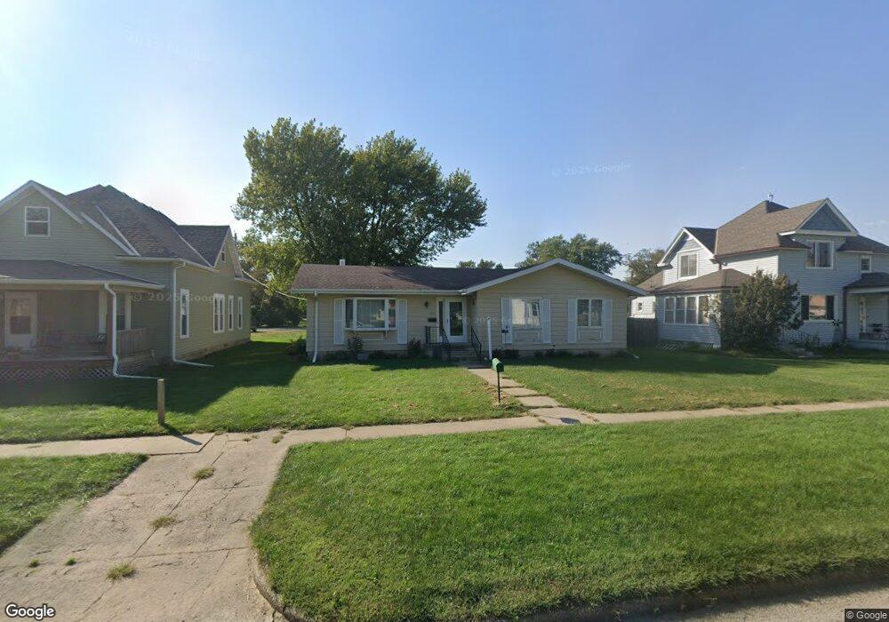
This home is located at 217 N 3rd Ave, Logan, IA 51546 and is currently estimated at $218,768, approximately $175 per square foot. 217 N 3rd Ave is a home located in Harrison County with nearby schools including Logan-Magnolia Elementary School and Logan-Magnolia Junior/Senior High School.
Ownership History
Date
Name
Owned For
Owner Type
Purchase Details
Closed on
Oct 24, 2014
Sold by
Carlson Corlis L and Kersten Sandra L
Bought by
Carlson Colis L
Current Estimated Value
Home Financials for this Owner
Home Financials are based on the most recent Mortgage that was taken out on this home.
Original Mortgage
$50,000
Interest Rate
4.21%
Mortgage Type
Unknown
Create a Home Valuation Report for This Property
The Home Valuation Report is an in-depth analysis detailing your home's value as well as a comparison with similar homes in the area
Purchase History
| Date | Buyer | Sale Price | Title Company |
|---|---|---|---|
| Carlson Colis L | -- | None Available |
Source: Public Records
Mortgage History
| Date | Status | Borrower | Loan Amount |
|---|---|---|---|
| Closed | Carlson Colis L | $50,000 |
Source: Public Records
Tax History
| Year | Tax Paid | Tax Assessment Tax Assessment Total Assessment is a certain percentage of the fair market value that is determined by local assessors to be the total taxable value of land and additions on the property. | Land | Improvement |
|---|---|---|---|---|
| 2025 | $3,238 | $202,180 | $13,500 | $188,680 |
| 2024 | $3,238 | $184,220 | $13,500 | $170,720 |
| 2023 | $3,124 | $184,220 | $13,500 | $170,720 |
| 2022 | $2,644 | $135,630 | $13,500 | $122,130 |
| 2021 | $2,644 | $135,630 | $13,500 | $122,130 |
| 2020 | $2,408 | $127,078 | $13,500 | $113,578 |
| 2019 | $2,512 | $127,078 | $13,500 | $113,578 |
| 2018 | $2,460 | $125,371 | $0 | $0 |
| 2017 | $2,460 | $125,371 | $0 | $0 |
| 2016 | $2,578 | $125,371 | $0 | $0 |
| 2015 | $2,578 | $112,947 | $0 | $0 |
| 2014 | $2,072 | $112,947 | $0 | $0 |
Source: Public Records
Map
Nearby Homes
- 217 N 2nd Ave
- 114 E 10th St
- 1010 Skyline Dr
- Lot 18 Mulligan Trail
- 2144 Norton Ave
- LOT 27 Mulligan Trail
- LOT 26 Lmvcc Estates
- 2464 Mulligan Trail
- LOT 20 Lmvcc Estates
- LOT 17 Lmvcc Estates
- LOT 15 Mulligan Trail
- 2853 Preston Place
- 0 Preston Place
- 0 Preston Place 2 Parcels
- LOTS 5 & 6 Fieldcrest Dr
- LOT D Fieldcrest Dr
- LOT 9 & 10 Fieldcrest Dr
- LOT E & K Fieldcrest Dr
- LOT C Fieldcrest Dr
- LOTS 7 & 8 Fieldcrest Dr
Your Personal Tour Guide
Ask me questions while you tour the home.