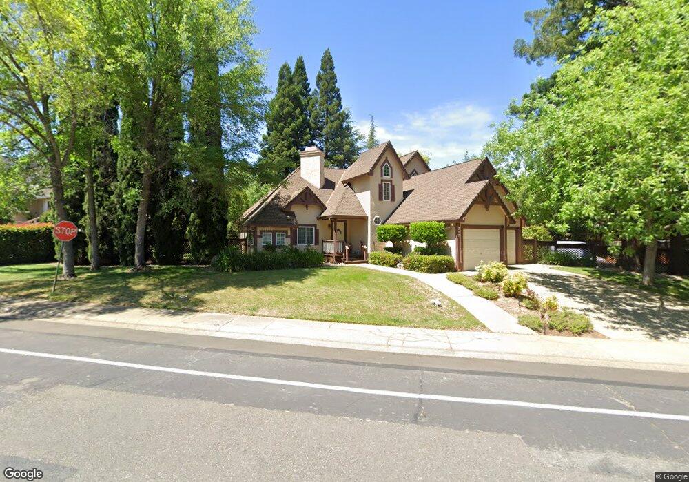
217 Randall Dr Folsom, CA 95630
Briggs Ranch NeighborhoodEstimated Value: $504,000 - $786,000
3
Beds
2
Baths
1,870
Sq Ft
$369/Sq Ft
Est. Value
About This Home
This home is located at 217 Randall Dr, Folsom, CA 95630 and is currently estimated at $689,391, approximately $368 per square foot. 217 Randall Dr is a home located in Sacramento County with nearby schools including Blanche Sprentz Elementary School, Sutter Middle School, and St. John Notre Dame School.
Ownership History
Date
Name
Owned For
Owner Type
Purchase Details
Closed on
Oct 24, 2012
Sold by
Claussen Lanette M
Bought by
Claussen Lanette M and The Claussen Family Revocable
Current Estimated Value
Home Financials for this Owner
Home Financials are based on the most recent Mortgage that was taken out on this home.
Original Mortgage
$165,800
Interest Rate
3.5%
Mortgage Type
New Conventional
Purchase Details
Closed on
Jun 6, 2011
Sold by
Claussen Arthur D and Claussen Lanette M
Bought by
Claussen Arthur D and Claussen Lanette M
Create a Home Valuation Report for This Property
The Home Valuation Report is an in-depth analysis detailing your home's value as well as a comparison with similar homes in the area
Home Values in the Area
Average Home Value in this Area
Purchase History
| Date | Buyer | Sale Price | Title Company |
|---|---|---|---|
| Claussen Lanette M | -- | Stewart Title Of Sacramento | |
| Claussen Lanette M | -- | Stewart Title Of Sacramento | |
| Claussen Arthur D | -- | None Available | |
| Claussen Arthur D | -- | None Available |
Source: Public Records
Mortgage History
| Date | Status | Borrower | Loan Amount |
|---|---|---|---|
| Closed | Claussen Lanette M | $165,800 |
Source: Public Records
Tax History Compared to Growth
Tax History
| Year | Tax Paid | Tax Assessment Tax Assessment Total Assessment is a certain percentage of the fair market value that is determined by local assessors to be the total taxable value of land and additions on the property. | Land | Improvement |
|---|---|---|---|---|
| 2025 | $1,310 | $295,750 | $78,072 | $217,678 |
| 2024 | $1,310 | $289,952 | $76,542 | $213,410 |
| 2023 | $1,345 | $284,268 | $75,042 | $209,226 |
| 2022 | $1,412 | $278,695 | $73,571 | $205,124 |
| 2021 | $1,388 | $273,231 | $72,129 | $201,102 |
| 2020 | $1,401 | $270,430 | $71,390 | $199,040 |
| 2019 | $1,389 | $265,129 | $69,991 | $195,138 |
| 2018 | $1,377 | $259,931 | $68,619 | $191,312 |
| 2017 | $1,297 | $254,835 | $67,274 | $187,561 |
| 2016 | $1,364 | $249,839 | $65,955 | $183,884 |
| 2015 | $1,309 | $246,087 | $64,965 | $181,122 |
| 2014 | $1,232 | $241,268 | $63,693 | $177,575 |
Source: Public Records
Map
Nearby Homes
- 124 Windstar Cir
- 164 Rebecca Way
- 237 Evelyn Way
- 109 Johnston Ct
- 801 Cristina Ct
- 260 Flower Dr
- 214 Rugosa Dr
- 128 Mesquite Ct
- 106 Rhoades Way
- 124 Fargo Way
- 103 Grenoble Way
- 102 Grenoble Way
- 1118 Buckbrush Dr
- 151 Glenn Dr
- 98-98 1/2 Dean Way
- 166 Market St
- 167 Price Way
- 182 Price Way
- 831 School St
- 1437 Cummings Way
- 213 Randall Dr
- 221 Randall Dr
- 112 Viento Ct
- 116 Viento Ct
- 216 Randall Dr
- 220 Randall Dr
- 225 Randall Dr
- 212 Randall Dr
- 103 Willow Creek Dr
- 108 Viento Ct
- 208 Randall Dr
- 229 Randall Dr
- 141 Cerrito Dr
- 113 Pradera Ct
- 100 Viento Ct
- 117 Pradera Ct
- 632 Cordillera Ct
- 104 Viento Ct
- 145 Cerrito Dr
- 116 Tiempo Ct