Estimated Value: $136,000 - $160,551
2
Beds
1
Bath
984
Sq Ft
$148/Sq Ft
Est. Value
About This Home
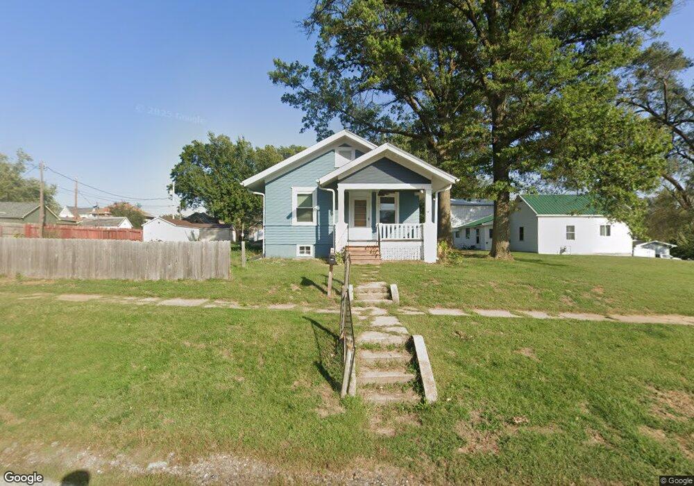
This home is located at 217 S 1st Ave, Logan, IA 51546 and is currently estimated at $145,388, approximately $147 per square foot. 217 S 1st Ave is a home located in Harrison County with nearby schools including Logan-Magnolia Elementary School and Logan-Magnolia Junior/Senior High School.
Ownership History
Date
Name
Owned For
Owner Type
Purchase Details
Closed on
Mar 27, 2024
Sold by
Mchugh Becky and Tupper Becky J
Bought by
Johnsen Douglas
Current Estimated Value
Home Financials for this Owner
Home Financials are based on the most recent Mortgage that was taken out on this home.
Original Mortgage
$104,000
Outstanding Balance
$101,680
Interest Rate
6.77%
Mortgage Type
Credit Line Revolving
Estimated Equity
$43,708
Create a Home Valuation Report for This Property
The Home Valuation Report is an in-depth analysis detailing your home's value as well as a comparison with similar homes in the area
Purchase History
| Date | Buyer | Sale Price | Title Company |
|---|---|---|---|
| Johnsen Douglas | $160,000 | None Listed On Document | |
| Johnsen Douglas | $160,000 | None Listed On Document |
Source: Public Records
Mortgage History
| Date | Status | Borrower | Loan Amount |
|---|---|---|---|
| Open | Johnsen Douglas | $104,000 | |
| Closed | Johnsen Douglas | $104,000 |
Source: Public Records
Tax History
| Year | Tax Paid | Tax Assessment Tax Assessment Total Assessment is a certain percentage of the fair market value that is determined by local assessors to be the total taxable value of land and additions on the property. | Land | Improvement |
|---|---|---|---|---|
| 2025 | $1,862 | $118,070 | $9,000 | $109,070 |
| 2024 | $1,862 | $105,950 | $9,000 | $96,950 |
| 2023 | $1,620 | $105,950 | $9,000 | $96,950 |
| 2022 | $1,336 | $77,435 | $9,000 | $68,435 |
| 2021 | $1,336 | $77,435 | $9,000 | $68,435 |
| 2020 | $1,198 | $72,032 | $9,000 | $63,032 |
| 2019 | $1,538 | $72,032 | $9,000 | $63,032 |
| 2018 | $1,508 | $76,816 | $0 | $0 |
| 2017 | $1,508 | $76,816 | $0 | $0 |
| 2016 | $1,400 | $76,816 | $0 | $0 |
| 2015 | $1,400 | $69,203 | $0 | $0 |
| 2014 | $1,214 | $69,203 | $0 | $0 |
Source: Public Records
Map
Nearby Homes
- 114 E 10th St
- 120 W 6th St
- 217 N 2nd Ave
- 1010 Skyline Dr
- Lot 18 Mulligan Trail
- LOT 27 Mulligan Trail
- LOT 26 Lmvcc Estates
- 2464 Mulligan Trail
- LOT 20 Lmvcc Estates
- LOT 17 Lmvcc Estates
- LOT 15 Mulligan Trail
- 2144 Norton Ave
- 2853 Preston Place
- TBD Preston Place 3 Parcels
- TBD Preston Place 2 Parcels
- LOT D Fieldcrest Dr
- LOT 9 & 10 Fieldcrest Dr
- LOT E & K Fieldcrest Dr
- LOT C Fieldcrest Dr
- LOTS 3 & 4 Fieldcrest Dr
Your Personal Tour Guide
Ask me questions while you tour the home.