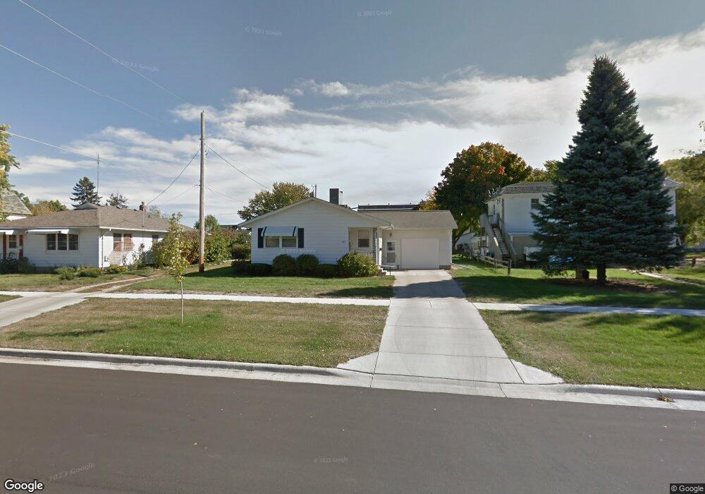
217 S Gorman St Blue Earth, MN 56013
Estimated Value: $145,000 - $176,000
2
Beds
1
Bath
1,172
Sq Ft
$135/Sq Ft
Est. Value
About This Home
This home is located at 217 S Gorman St, Blue Earth, MN 56013 and is currently estimated at $157,955, approximately $134 per square foot. 217 S Gorman St is a home located in Faribault County with nearby schools including Blue Earth Area High School.
Ownership History
Date
Name
Owned For
Owner Type
Purchase Details
Closed on
Feb 9, 2024
Sold by
Trytten Betty
Bought by
Grunklee Katelynn
Current Estimated Value
Home Financials for this Owner
Home Financials are based on the most recent Mortgage that was taken out on this home.
Original Mortgage
$110,731
Outstanding Balance
$108,778
Interest Rate
6.62%
Mortgage Type
New Conventional
Estimated Equity
$49,177
Purchase Details
Closed on
Feb 9, 2023
Sold by
Trytten Betty
Bought by
Grunklee Katelynn
Home Financials for this Owner
Home Financials are based on the most recent Mortgage that was taken out on this home.
Original Mortgage
$110,731
Interest Rate
6.12%
Mortgage Type
New Conventional
Purchase Details
Closed on
Jun 7, 2018
Sold by
Stevermen Thomas C
Bought by
Trytten Betty
Purchase Details
Closed on
Jun 29, 2007
Sold by
Community Bank Vernon Center
Bought by
Ozuna Erael and Ozuna Maria Del R
Create a Home Valuation Report for This Property
The Home Valuation Report is an in-depth analysis detailing your home's value as well as a comparison with similar homes in the area
Home Values in the Area
Average Home Value in this Area
Purchase History
| Date | Buyer | Sale Price | Title Company |
|---|---|---|---|
| Grunklee Katelynn | $135,000 | Minnesota River Valley Title | |
| Grunklee Katelynn | $135,000 | -- | |
| Trytten Betty | $65,000 | None Available | |
| Ozuna Erael | $32,500 | None Available |
Source: Public Records
Mortgage History
| Date | Status | Borrower | Loan Amount |
|---|---|---|---|
| Open | Grunklee Katelynn | $110,731 | |
| Previous Owner | Grunklee Katelynn | $110,731 |
Source: Public Records
Tax History Compared to Growth
Tax History
| Year | Tax Paid | Tax Assessment Tax Assessment Total Assessment is a certain percentage of the fair market value that is determined by local assessors to be the total taxable value of land and additions on the property. | Land | Improvement |
|---|---|---|---|---|
| 2025 | $1,380 | $151,600 | $19,500 | $132,100 |
| 2024 | $1,446 | $123,600 | $10,300 | $113,300 |
| 2023 | $1,122 | $120,700 | $9,800 | $110,900 |
| 2022 | $926 | $92,600 | $9,800 | $82,800 |
| 2021 | $890 | $76,700 | $4,500 | $72,200 |
| 2020 | $768 | $76,700 | $4,500 | $72,200 |
| 2019 | $776 | $74,300 | $3,800 | $70,500 |
| 2018 | $826 | $75,900 | $5,400 | $70,500 |
| 2017 | $798 | $79,400 | $5,400 | $74,000 |
| 2015 | $726 | $79,400 | $5,400 | $74,000 |
| 2013 | -- | $79,400 | $5,400 | $74,000 |
Source: Public Records
Map
Nearby Homes
- 208 S Ramsey St
- 527 E 6th St
- 323 S Galbraith St
- 215 N Galbraith St
- 421 S Moore St
- 512 E 11th St
- 306 E 3rd St
- 920 E 6th St
- 613 S Galbraith St
- 227 E 2nd St
- 630 E 13th St
- 427 N Sailor St
- 215 E 1st St
- 415 W 4th St
- 223 W 1st St
- 223 Oak Knoll Ct
- 1201 Buccaneer Dr
- 106 Prairie Rose Dr
- 102 Prairie Rose Dr
- 105 Bluestem Dr